TopoQuest Logo
Do you find TopoQuest useful?
Help keep TopoQuest running and adding new maps/features by donating!
Bitcoin:  19c7KJd3qBynnjoSw5npx9KScwjBe4ifkT
Litecoin:  LXs6TkuXGGXo1vDsWCkWVdjQX94eUKd6ui
Home View Maps Find Maps Find Places Resources & Links


White City, Alabama Topographic Map

USGS Map Title: White City, AL
USGS Map MRC: 32086F5
DRG (GeoTIFF) Download: o32086f5.tif


Neighboring USGS Topographic Map Quads:


  Clanton West, AL  
32086G6
 

  Clanton East, AL  
32086G5
 

  Mitchell Dam, AL  
32086G4
 

  Billingsley, AL  
32086F6
 

  White City, AL  
32086F5
 

  Marbury, AL  
32086F4
 

  Vida, AL  
32086E6
 

  Old Kingston, AL  
32086E5
 

  Deatsville, AL  
32086E4


Map MRC Location:

N33°
W87°
N33°
W86°
H8 H7 H6 H5 H4 H3 H2 H1
G8 G7 G6 G5 G4 G3 G2 G1
F8 F7 F6 F5 F4 F3 F2 F1
E8 E7 E6 E5 E4 E3 E2 E1
D8 D7 D6 D5 D4 D3 D2 D1
C8 C7 C6 C5 C4 C3 C2 C1
B8 B7 B6 B5 B4 B3 B2 B1
A8 A7 A6 A5 A4 A3 A2 A1
N32°
W87°
N32°
W86°

White City, AL USGS 1:24K Topographic Map Preview:
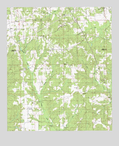
White City, AL USGS Topographic Map
Click on map above to begin viewing in our Map Viewer.

This topographic map contains these locations and features:
Feature Name Type Latitude Longitude GNIS ID View Map
Bear BranchStreamN32.7432°W86.5714°113634View Map
Bethany CemeteryCemeteryN32.7285°W86.6214°151278View Map
Bethany ChurchChurchN32.7282°W86.6205°113993View Map
Bildee CemeteryCemeteryN32.7493°W86.5319°147531View Map
Caney BranchStreamN32.7379°W86.5805°115564View Map
Cooper CemeteryCemeteryN32.7065°W86.5739°116574View Map
Cooper CemeteryCemeteryN32.7312°W86.5591°116575View Map
Crossroad CemeteryCemeteryN32.7421°W86.5550°151281View Map
Crossroad ChurchChurchN32.7421°W86.5547°116898View Map
EnterprisePopulated PlaceN32.7349°W86.6180°118006View Map
Enterprise Junior High School (historical)SchoolN32.7349°W86.6172°149287View Map
Enterprise Volunteer Fire and Rescue Station 1BuildingN32.7350°W86.6172°2691190View Map
Evergreen CemeteryCemeteryN32.7312°W86.5575°118081View Map
First Born ChurchChurchN32.7076°W86.5589°149488View Map
Floyd Baptist ChurchChurchN32.7210°W86.5819°151774View Map
Floyd CemeteryCemeteryN32.7204°W86.5819°151279View Map
Gladden School (historical)SchoolN32.6335°W86.5886°147567View Map
Interchange 200CrossingN32.7368°W86.5430°155589View Map
Little CreekStreamN32.6832°W86.5947°121753View Map
Manning CemeteryCemeteryN32.6332°W86.5222°122255View Map
Marbury DivisionCivilN32.6430°W86.5238°165648View Map
McKensey CreekStreamN32.6604°W86.5861°152281View Map
New Lily Hill CemeteryCemeteryN32.7071°W86.5700°151280View Map
New Lily Hill ChurchChurchN32.7076°W86.5703°123863View Map
New ProspectPopulated PlaceN32.6651°W86.5386°147596View Map
New Prospect CemeteryCemeteryN32.6682°W86.5397°123878View Map
New Prospect ChurchChurchN32.6632°W86.5339°123885View Map
Pentacost Volunteer Fire DepartmentBuildingN32.6920°W86.5529°2691157View Map
Pentecost ChurchChurchN32.6924°W86.5558°147611View Map
Pentecost SchoolSchoolN32.6924°W86.5530°124597View Map
Pleasant Valley Baptist ChurchChurchN32.7357°W86.6122°151277View Map
Pleasant Valley CemeteryCemeteryN32.7357°W86.6125°151276View Map
Sunny Hill CemeteryCemeteryN32.6607°W86.5028°149286View Map
Sunny Hill ChurchChurchN32.6579°W86.5028°127558View Map
VerbenaPopulated PlaceN32.7499°W86.5114°153838View Map
Verbena ChurchChurchN32.7496°W86.5125°149504View Map
Verbena High SchoolSchoolN32.7490°W86.5089°149285View Map
White CityPopulated PlaceN32.6485°W86.5994°128868View Map
White City Volunteer Fire DepartmentBuildingN32.6476°W86.5995°2691550View Map
White Pond Baptist ChurchChurchN32.6468°W86.6019°154285View Map
White SpringSpringN32.6571°W86.6050°147666View Map
Zions Rest ChurchChurchN32.6876°W86.6044°129363View Map

Note: Coordinates in the location and feature list above are referenced to NAD83 datum.


Copyright (C) 2008-2025 Ryan Niemi / Sunset Dynamics ... All Rights Reserved