TopoQuest Logo
Do you find TopoQuest useful?
Help keep TopoQuest running and adding new maps/features by donating!
Bitcoin:  19c7KJd3qBynnjoSw5npx9KScwjBe4ifkT
Litecoin:  LXs6TkuXGGXo1vDsWCkWVdjQX94eUKd6ui
Home View Maps Find Maps Find Places Resources & Links


Cleghorn, Wisconsin Topographic Map

USGS Map Title: Cleghorn, WI
USGS Map MRC: 44091F4
DRG (GeoTIFF) Download: o44091f4.tif


Neighboring USGS Topographic Map Quads:


  Eau Claire West, WI  
44091G5
 

  Eau Claire East, WI  
44091G4
 

  Fall Creek, WI  
44091G3
 

  Mondovi NE, WI  
44091F5
 

  Cleghorn, WI  
44091F4
 

  Brackett, WI  
44091F3
 

  Rossman Creek, WI  
44091E5
 

  Strum, WI  
44091E4
 

  Strum SE, WI  
44091E3


Map MRC Location:

N45°
W92°
N45°
W91°
H8 H7 H6 H5 H4 H3 H2 H1
G8 G7 G6 G5 G4 G3 G2 G1
F8 F7 F6 F5 F4 F3 F2 F1
E8 E7 E6 E5 E4 E3 E2 E1
D8 D7 D6 D5 D4 D3 D2 D1
C8 C7 C6 C5 C4 C3 C2 C1
B8 B7 B6 B5 B4 B3 B2 B1
A8 A7 A6 A5 A4 A3 A2 A1
N44°
W92°
N44°
W91°

Cleghorn, WI USGS 1:24K Topographic Map Preview:
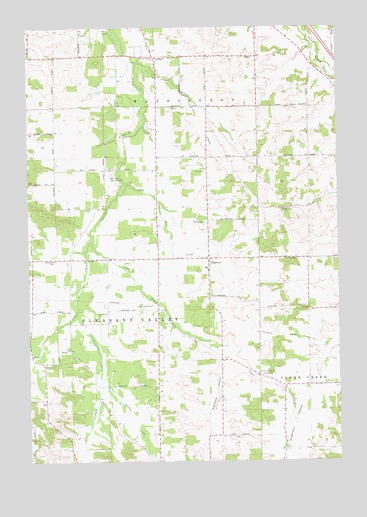
Cleghorn, WI USGS Topographic Map
Click on map above to begin viewing in our Map Viewer.

This topographic map contains these locations and features:
Feature Name Type Latitude Longitude GNIS ID View Map
Anderson ValleyValleyN44.6454°W91.3917°1560863View Map
Blue Collar FarmsLocaleN44.7106°W91.3789°2727285View Map
Carlson AirportAirportN44.7228°W91.4594°1581959View Map
Christenson FarmsLocaleN44.7356°W91.4294°2727287View Map
Clear CreekStreamN44.6883°W91.4746°1563143View Map
CleghornPopulated PlaceN44.6836°W91.4268°1563173View Map
Conley School (historical)SchoolN44.6752°W91.4985°1846648View Map
Eau Claire OrchardLocaleN44.7381°W91.4933°2611790View Map
Graham CreekStreamN44.6675°W91.4807°1565706View Map
Hadleyville CemeteryCemeteryN44.6830°W91.4890°1565959View Map
Hillside School (historical)SchoolN44.7127°W91.4068°1846686View Map
Hillview FarmLocaleN44.7103°W91.4117°2611791View Map
Keiser School (historical)SchoolN44.7091°W91.4838°1846697View Map
Kelley CreekStreamN44.6477°W91.4704°1567380View Map
Kelley School (historical)SchoolN44.6577°W91.4488°1846698View Map
Kneeland School (historical)SchoolN44.6397°W91.3974°1846701View Map
Mertinkes AirportAirportN44.7037°W91.4673°1581958View Map
Otter Creek Valley FarmLocaleN44.7292°W91.3772°2727333View Map
Pine CreekStreamN44.7052°W91.4607°1571429View Map
Pleasant Valley ChurchChurchN44.6502°W91.4074°1571652View Map
Porter School (historical)SchoolN44.7411°W91.4485°1846738View Map
Saint Paul CemeteryCemeteryN44.6833°W91.3910°1573435View Map
Saint Paul Church (historical)ChurchN44.6830°W91.3918°1846759View Map
Schoolhouse CreekStreamN44.6547°W91.4202°1846764View Map
Shaw School (historical)SchoolN44.6466°W91.4221°1846769View Map
Sigmund ValleyValleyN44.6536°W91.4202°1574092View Map
Stewart FarmLocaleN44.7472°W91.4822°2727332View Map
Town of Pleasant ValleyCivilN44.6616°W91.4681°1583938View Map
Town of WashingtonCivilN44.7498°W91.4019°1584353View Map
Township Fire Department Station 4 Pleasant ValleyBuildingN44.6813°W91.4278°2698106View Map
Union CemeteryCemeteryN44.6500°W91.4068°1575891View Map
Willow CreekStreamN44.7400°W91.4577°1576781View Map
Willow Creek FarmLocaleN44.7278°W91.4256°2727326View Map
Zion CemeteryCemeteryN44.7086°W91.4274°1577146View Map
Zion Church (historical)ChurchN44.7080°W91.4282°1846791View Map

Note: Coordinates in the location and feature list above are referenced to NAD83 datum.


Copyright (C) 2008-2025 Ryan Niemi / Sunset Dynamics ... All Rights Reserved