TopoQuest Logo
Do you find TopoQuest useful?
Help keep TopoQuest running and adding new maps/features by donating!
Bitcoin:  19c7KJd3qBynnjoSw5npx9KScwjBe4ifkT
Litecoin:  LXs6TkuXGGXo1vDsWCkWVdjQX94eUKd6ui
Home View Maps Find Maps Find Places Resources & Links


Clifton, Illinois Topographic Map

USGS Map Title: Clifton, IL
USGS Map MRC: 40087H8
DRG (GeoTIFF) Download: o40087h8.tif


Neighboring USGS Topographic Map Quads:


  Herscher, IL  
41088A1
 

  West Kankakee, IL  
41087A8
 

  Kankakee, IL  
41087A7
 

  Piper City NE, IL  
40088H1
 

  Clifton, IL  
40087H8
 

  L'Erable, IL  
40087H7
 

  La Hogue, IL  
40088G1
 

  Gilman, IL  
40087G8
 

  Crescent City, IL  
40087G7


Map MRC Location:

N41°
W88°
N41°
W87°
H8 H7 H6 H5 H4 H3 H2 H1
G8 G7 G6 G5 G4 G3 G2 G1
F8 F7 F6 F5 F4 F3 F2 F1
E8 E7 E6 E5 E4 E3 E2 E1
D8 D7 D6 D5 D4 D3 D2 D1
C8 C7 C6 C5 C4 C3 C2 C1
B8 B7 B6 B5 B4 B3 B2 B1
A8 A7 A6 A5 A4 A3 A2 A1
N40°
W88°
N40°
W87°

Clifton, IL USGS 1:24K Topographic Map Preview:
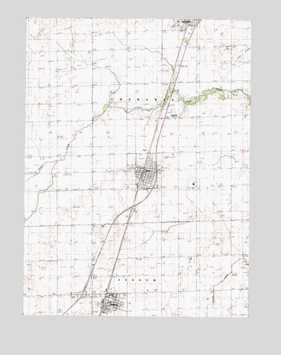
Clifton, IL USGS Topographic Map
Click on map above to begin viewing in our Map Viewer.

This topographic map contains these locations and features:
Feature Name Type Latitude Longitude GNIS ID View Map
AshkumPopulated PlaceN40.8803°W87.9550°403669View Map
Ashkum Elementary SchoolSchoolN40.8811°W87.9517°1815544View Map
Ashkum Post OfficePost OfficeN40.8801°W87.9549°1815545View Map
Ashkum Township Fire Protection DistrictBuildingN40.8790°W87.9548°2681735View Map
Ashkum United Methodist ChurchChurchN40.8811°W87.9509°1986110View Map
Brown School (historical)SchoolN40.9136°W87.9820°404959View Map
Central High SchoolSchoolN40.9595°W87.9178°1815546View Map
Chebanse Elementary SchoolSchoolN40.9992°W87.9159°1815547View Map
Chebanse Township Rural Fire Protection DistrictBuildingN40.9362°W87.9383°2682565View Map
CliftonPopulated PlaceN40.9353°W87.9345°406252View Map
Clifton Baptist ChurchChurchN40.9353°W87.9387°1986113View Map
Clifton Elementary SchoolSchoolN40.9336°W87.9309°1815550View Map
Clifton Post OfficePost OfficeN40.9319°W87.9341°1815551View Map
Clifton Wesleyan ChurchChurchN40.9356°W87.9359°1986114View Map
Heller School (historical)SchoolN40.9586°W87.9059°410038View Map
Illinois State Police Department District 21BuildingN40.8843°W87.9521°2757180View Map
Interchange 293CrossingN40.8842°W87.9673°1815563View Map
Interchange 297CrossingN40.9289°W87.9292°1815564View Map
Interchange 302CrossingN40.9998°W87.9056°1815565View Map
John L Nash Middle SchoolSchoolN40.9598°W87.9164°1815573View Map
Leggottville School (historical)SchoolN40.9706°W87.9809°411924View Map
Saint Mary & Joseph CemeteryCemeteryN40.9970°W87.9184°1951737View Map
Saint Mary and Josephs ChurchChurchN40.9981°W87.9117°1986112View Map
Swival School (historical)SchoolN40.9342°W87.9920°419495View Map
Tatro School (historical)SchoolN40.9017°W87.9048°419551View Map
Township of AshkumCivilN40.8846°W87.9811°428607View Map
Township of ChebanseCivilN40.9586°W87.9153°428794View Map
Village of AshkumCivilN40.8782°W87.9531°2397995View Map
Village of CliftonCivilN40.9345°W87.9340°2397649View Map
Zion Lutheran ChurchChurchN40.8800°W87.9520°1986111View Map
Zion Lutheran Church of CliftonChurchN40.9378°W87.9378°1986115View Map

Note: Coordinates in the location and feature list above are referenced to NAD83 datum.


Copyright (C) 2008-2025 Ryan Niemi / Sunset Dynamics ... All Rights Reserved