TopoQuest Logo
Do you find TopoQuest useful?
Help keep TopoQuest running and adding new maps/features by donating!
Bitcoin:  19c7KJd3qBynnjoSw5npx9KScwjBe4ifkT
Litecoin:  LXs6TkuXGGXo1vDsWCkWVdjQX94eUKd6ui
Home View Maps Find Maps Find Places Resources & Links


Clines Island, Missouri Topographic Map

USGS Map Title: Clines Island, MO
USGS Map MRC: 36089H7
DRG (GeoTIFF) Download: o36089h7.tif


Neighboring USGS Topographic Map Quads:


  Advance, MO  
37089A8
 

  Bell City, MO  
37089A7
 

  Oran, MO  
37089A6
 

  Bloomfield, MO  
36089H8
 

  Clines Island, MO  
36089H7
 

  Vanduser, MO  
36089H6
 

  Dexter, MO  
36089G8
 

  Essex, MO  
36089G7
 

  Morehouse, MO  
36089G6


Map MRC Location:

N37°
W90°
N37°
W89°
H8 H7 H6 H5 H4 H3 H2 H1
G8 G7 G6 G5 G4 G3 G2 G1
F8 F7 F6 F5 F4 F3 F2 F1
E8 E7 E6 E5 E4 E3 E2 E1
D8 D7 D6 D5 D4 D3 D2 D1
C8 C7 C6 C5 C4 C3 C2 C1
B8 B7 B6 B5 B4 B3 B2 B1
A8 A7 A6 A5 A4 A3 A2 A1
N36°
W90°
N36°
W89°

Clines Island, MO USGS 1:24K Topographic Map Preview:
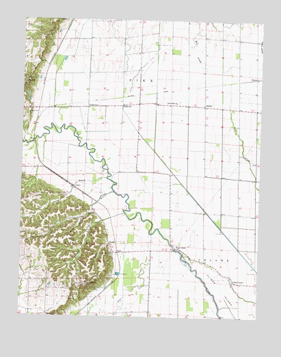
Clines Island, MO USGS Topographic Map
Click on map above to begin viewing in our Map Viewer.

This topographic map contains these locations and features:
Feature Name Type Latitude Longitude GNIS ID View Map
Artesian Well (historical)WellN36.9614°W89.7712°747682View Map
AvertPopulated PlaceN36.9295°W89.8479°713502View Map
Beech Grove BranchStreamN36.9273°W89.8262°713875View Map
Beech Grove ChurchChurchN36.9181°W89.8398°713876View Map
Beech Grove SchoolSchoolN36.9187°W89.8401°747678View Map
Birds CornerPopulated PlaceN36.8898°W89.7637°714264View Map
Bluff Hill CemeteryCemeteryN36.8753°W89.8606°714443View Map
Bridges Post OfficePost OfficeN36.9556°W89.8681°740337View Map
Clines IslandIslandN36.8809°W89.7626°715993View Map
Clines IslandPopulated PlaceN36.9039°W89.7937°715994View Map
Clines Island School (historical)SchoolN36.9009°W89.7859°730428View Map
Ditch Number 24CanalN36.8956°W89.7509°737839View Map
Ditch Number 30CanalN36.9814°W89.8229°737836View Map
Ditch Number 33CanalN36.9787°W89.7887°737837View Map
Ditch Number 34CanalN36.9534°W89.7704°737838View Map
DurnellPopulated PlaceN36.9687°W89.8143°740125View Map
Ellis CemeteryCemeteryN36.8820°W89.8490°717493View Map
Garden Ridge ChurchChurchN36.9653°W89.7943°718336View Map
Garden Ridge SchoolSchoolN36.9648°W89.7954°747679View Map
GuamPopulated PlaceN36.9020°W89.8237°740891View Map
HimmelPopulated PlaceN36.9762°W89.7529°740930View Map
Hopkins CemeteryCemeteryN36.9748°W89.8729°719819View Map
Indiana Spur (historical)LocaleN36.9734°W89.7715°747680View Map
Lewis Lake DamDamN36.9151°W89.8434°765557View Map
Mill SloughStreamN36.9737°W89.7759°722358View Map
Montgomery Lake Lower DamDamN36.9667°W89.8734°765556View Map
Montgomery Lake Upper DamDamN36.9684°W89.8718°765560View Map
Moore CemeteryCemeteryN36.9931°W89.8651°722577View Map
Oak CemeteryCemeteryN36.9820°W89.8665°723553View Map
Palmer CemeteryCemeteryN36.9606°W89.8715°723975View Map
Poplar BranchStreamN36.9334°W89.8304°724750View Map
Rice LakeReservoirN36.9951°W89.8701°765562View Map
Rice Lake Dam EastDamN36.9951°W89.8701°765561View Map
Rice Lake West DamDamN36.9951°W89.8718°765558View Map
Shady DellPopulated PlaceN36.9639°W89.8226°741260View Map
ShawanPopulated PlaceN36.9639°W89.7798°729813View Map
Shawnan School (historical)LocaleN36.9642°W89.7790°759466View Map
South Master School (historical)SchoolN36.9620°W89.7512°747681View Map
ToppertownPopulated PlaceN36.9631°W89.8412°727714View Map
Williams (historical)LocaleN36.9209°W89.8312°740338View Map
Williams CreekStreamN36.9181°W89.8201°735918View Map
Wilson CreekStreamN36.8862°W89.8201°728969View Map
Zeta (historical)Populated PlaceN36.9556°W89.8681°739875View Map

Note: Coordinates in the location and feature list above are referenced to NAD83 datum.


Copyright (C) 2008-2025 Ryan Niemi / Sunset Dynamics ... All Rights Reserved