TopoQuest Logo
Do you find TopoQuest useful?
Help keep TopoQuest running and adding new maps/features by donating!
Bitcoin:  19c7KJd3qBynnjoSw5npx9KScwjBe4ifkT
Litecoin:  LXs6TkuXGGXo1vDsWCkWVdjQX94eUKd6ui
Home View Maps Find Maps Find Places Resources & Links


Dexter, Missouri Topographic Map

USGS Map Title: Dexter, MO
USGS Map MRC: 36089G8
DRG (GeoTIFF) Download: o36089g8.tif


Neighboring USGS Topographic Map Quads:


  Acorn Ridge, MO  
36090H1
 

  Bloomfield, MO  
36089H8
 

  Clines Island, MO  
36089H7
 

  Dudley, MO  
36090G1
 

  Dexter, MO  
36089G8
 

  Essex, MO  
36089G7
 

  Powe, MO  
36090F1
 

  Bernie, MO  
36089F8
 

  Hills Store, MO  
36089F7


Map MRC Location:

N37°
W90°
N37°
W89°
H8 H7 H6 H5 H4 H3 H2 H1
G8 G7 G6 G5 G4 G3 G2 G1
F8 F7 F6 F5 F4 F3 F2 F1
E8 E7 E6 E5 E4 E3 E2 E1
D8 D7 D6 D5 D4 D3 D2 D1
C8 C7 C6 C5 C4 C3 C2 C1
B8 B7 B6 B5 B4 B3 B2 B1
A8 A7 A6 A5 A4 A3 A2 A1
N36°
W90°
N36°
W89°

Dexter, MO USGS 1:24K Topographic Map Preview:
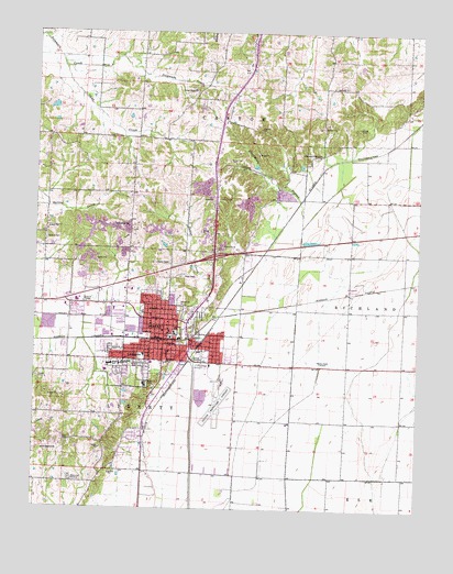
Dexter, MO USGS Topographic Map
Click on map above to begin viewing in our Map Viewer.

This topographic map contains these locations and features:
Feature Name Type Latitude Longitude GNIS ID View Map
Bartletts Fishing Lake DamDamN36.8067°W89.9851°765551View Map
Blackshire BranchStreamN36.8239°W89.9131°714333View Map
Cane CreekStreamN36.8659°W89.9917°715339View Map
Central SchoolSchoolN36.7962°W89.9543°715682View Map
City of DexterCivilN36.7931°W89.9632°2394530View Map
DexterPopulated PlaceN36.7959°W89.9579°716871View Map
Dexter CemeteryCemeteryN36.8006°W89.9454°716872View Map
Dexter CreekStreamN36.7884°W89.9476°716873View Map
Dexter Fire Department Station 2BuildingN36.7962°W89.9662°2621038View Map
Dexter Fire Department Station 3BuildingN36.7927°W89.9533°2621536View Map
Dexter JunctionLocaleN36.8003°W89.9406°740348View Map
Dexter Memorial Hospital HeliportAirportN36.8073°W89.9681°758656View Map
Dexter Municipal AirportAirportN36.7824°W89.9390°758655View Map
Dexter Police DepartmentBuildingN36.7967°W89.9662°2752100View Map
Dexter Post OfficePost OfficeN36.7929°W89.9547°2782961View Map
Dowdy CemeteryCemeteryN36.7842°W89.9990°717026View Map
East ParkParkN36.7878°W89.9454°717330View Map
Edwards School (historical)SchoolN36.8473°W89.9954°747683View Map
Ezell CemeteryCemeteryN36.7684°W89.9879°717715View Map
Ezell School (historical)SchoolN36.7653°W89.9979°747685View Map
Gilead Hills ChurchChurchN36.8601°W89.9484°718440View Map
Hagy CemeteryCemeteryN36.8112°W89.9523°718974View Map
Hill SchoolSchoolN36.8573°W89.9434°747687View Map
Jerusalem ChurchChurchN36.8239°W89.9698°720309View Map
KDEX-AM (Dexter)TowerN36.7884°W89.9062°759283View Map
KDEX-FM (Dexter)TowerN36.7884°W89.9062°754247View Map
Kinder CemeteryCemeteryN36.8503°W89.8956°720595View Map
Lambert SchoolSchoolN36.7542°W89.9995°747686View Map
Lost School (historical)SchoolN36.8148°W89.9870°730429View Map
Memorial GardensCemeteryN36.7578°W89.9876°722216View Map
Miller CemeteryCemeteryN36.7873°W89.9659°722372View Map
Missouri State Veterans Cemetery - BloomfieldCemeteryN36.8640°W89.9332°2776793View Map
New Bethel ChurchChurchN36.7653°W89.9970°723180View Map
Ott SchoolSchoolN36.8273°W89.8993°747688View Map
Panther Swamp (historical)SwampN36.8270°W89.9031°739876View Map
Pleasant Valley ChurchChurchN36.8428°W89.9079°724617View Map
Renner School (historical)SchoolN36.8267°W89.9406°747684View Map
Sadler Chapel CemeteryCemeteryN36.8206°W89.9970°725710View Map
Southeast Health Medical Center Stoddard CountyHospitalN36.8071°W89.9686°2655049View Map
Southwest SchoolSchoolN36.7878°W89.9723°726818View Map
Stoddard CountyCivilN36.8556°W89.9443°758556View Map
Tatum School (historical)SchoolN36.7587°W89.9348°747690View Map
Walnut Ridge School (historical)SchoolN36.7873°W89.8976°747689View Map

Note: Coordinates in the location and feature list above are referenced to NAD83 datum.


Copyright (C) 2008-2024 Ryan Niemi / Sunset Dynamics ... All Rights Reserved