TopoQuest Logo
Do you find TopoQuest useful?
Help keep TopoQuest running and adding new maps/features by donating!
Bitcoin:  19c7KJd3qBynnjoSw5npx9KScwjBe4ifkT
Litecoin:  LXs6TkuXGGXo1vDsWCkWVdjQX94eUKd6ui
Home View Maps Find Maps Find Places Resources & Links


Clio, West Virginia Topographic Map

USGS Map Title: Clio, WV
USGS Map MRC: 38081E3
DRG (GeoTIFF) Download: o38081e3.tif


Neighboring USGS Topographic Map Quads:


  Walton, WV  
38081F4
 

  Looneyville, WV  
38081F3
 

  Tariff, WV  
38081F2
 

  Kettle, WV  
38081E4
 

  Clio, WV  
38081E3
 

  Newton, WV  
38081E2
 

  Blue Creek, WV  
38081D4
 

  Clendenin, WV  
38081D3
 

  Elkhurst, WV  
38081D2


Map MRC Location:

N39°
W82°
N39°
W81°
H8 H7 H6 H5 H4 H3 H2 H1
G8 G7 G6 G5 G4 G3 G2 G1
F8 F7 F6 F5 F4 F3 F2 F1
E8 E7 E6 E5 E4 E3 E2 E1
D8 D7 D6 D5 D4 D3 D2 D1
C8 C7 C6 C5 C4 C3 C2 C1
B8 B7 B6 B5 B4 B3 B2 B1
A8 A7 A6 A5 A4 A3 A2 A1
N38°
W82°
N38°
W81°

Clio, WV USGS 1:24K Topographic Map Preview:
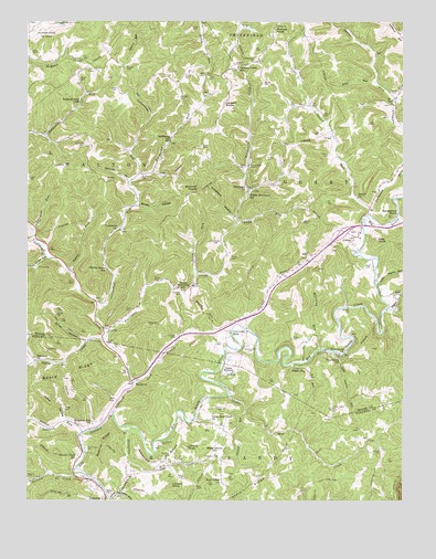
Clio, WV USGS Topographic Map
Click on map above to begin viewing in our Map Viewer.

This topographic map contains these locations and features:
Feature Name Type Latitude Longitude GNIS ID View Map
AmmaPopulated PlaceN38.5687°W81.2657°1534922View Map
Amma CemeteryCemeteryN38.5666°W81.2685°2586130View Map
Amma Methodist ChurchChurchN38.5662°W81.2685°1740846View Map
Amma Post OfficePost OfficeN38.5748°W81.2610°1740847View Map
Andy RunStreamN38.5723°W81.3054°1534953View Map
Armstead CemeteryCemeteryN38.5673°W81.3112°1535010View Map
Armstead HollowValleyN38.5740°W81.3062°1535011View Map
Ashley CemeteryCemeteryN38.5729°W81.2834°1535061View Map
Ashwood BranchStreamN38.5829°W81.3415°1535064View Map
Barnhouse CemeteryCemeteryN38.5843°W81.3373°1535273View Map
Bethel Baptist ChurchChurchN38.5790°W81.2654°1535700View Map
Bird CemeteryCemeteryN38.5870°W81.3643°1536036View Map
Board RidgeRidgeN38.5326°W81.3604°1536163View Map
Brown HollowValleyN38.5773°W81.3379°1536411View Map
Bufflick RunStreamN38.5176°W81.3562°1536669View Map
Camp WhitneyLocaleN38.5323°W81.3104°1536968View Map
Canterbury CemeteryCemeteryN38.5393°W81.3687°1537017View Map
Carper CemeteryCemeteryN38.5904°W81.2748°1537059View Map
Carper CemeteryCemeteryN38.6065°W81.2543°1537060View Map
Casey CemeteryCemeteryN38.5415°W81.3484°1537083View Map
ClioPopulated PlaceN38.5812°W81.3012°1537421View Map
Clio Post OfficePost OfficeN38.5807°W81.3012°1740870View Map
Cobb HollowValleyN38.5857°W81.3329°1537483View Map
Coleman RunStreamN38.5709°W81.3732°1537517View Map
CottonPopulated PlaceN38.5448°W81.3498°1537698View Map
Cottontree ChurchChurchN38.5707°W81.3443°1537700View Map
Cottontree RunStreamN38.5507°W81.3504°1537701View Map
Cummings CemeteryCemeteryN38.5137°W81.3548°1537907View Map
Curtis CemeteryCemeteryN38.6106°W81.3232°1537938View Map
Davis RunStreamN38.5590°W81.3182°1538049View Map
Deverick CemeteryCemeteryN38.5120°W81.3271°1538149View Map
Deverick RidgeRidgeN38.5107°W81.3304°1538151View Map
District IIICivilN38.6159°W81.2929°1953487View Map
Doctors CreekStreamN38.5070°W81.3587°1538226View Map
Doctors Creek School (historical)SchoolN38.5109°W81.3585°1538227View Map
Doelick RidgeRidgeN38.5148°W81.3490°1538232View Map
Doelick RunStreamN38.5229°W81.3026°1538233View Map
Fairview ChurchChurchN38.5365°W81.3721°1538807View Map
Gabes CreekStreamN38.5423°W81.3493°1539307View Map
Gandee CemeteryCemeteryN38.5429°W81.3254°1539317View Map
Gandee CemeteryCemeteryN38.6051°W81.3248°1539318View Map
Garner BranchStreamN38.5451°W81.3032°1539338View Map
Green CemeteryCemeteryN38.5840°W81.3746°1539668View Map
Groves CemeteryCemeteryN38.6081°W81.2962°1539771View Map
Hardcamp RunStreamN38.5851°W81.3379°1539936View Map
Hardcamp School (historical)SchoolN38.5937°W81.3279°1539937View Map
Harper CemeteryCemeteryN38.5126°W81.2573°1539990View Map
Hershberger CemeteryCemeteryN38.6151°W81.2996°1540179View Map
Hindsman CemeteryCemeteryN38.5148°W81.3301°1540310View Map
Hively CemeteryCemeteryN38.6162°W81.3726°1540324View Map
Holbert CemeteryCemeteryN38.5837°W81.3490°1540374View Map
Horseshoe BendBendN38.5754°W81.2515°1540508View Map
Hurricane ChurchChurchN38.5812°W81.3018°1540623View Map
Hurricane CreekStreamN38.5437°W81.3485°1540625View Map
Interchange 19CrossingN38.5309°W81.3407°1741915View Map
Interchange 25CrossingN38.5701°W81.2696°1740910View Map
J Herbert Smith CemeteryCemeteryN38.6211°W81.2906°2586161View Map
Jackson CemeteryCemeteryN38.5543°W81.3240°1540776View Map
Jackson CemeteryCemeteryN38.6140°W81.3065°1540777View Map
Jackson RocksSummitN38.6034°W81.3096°1554791View Map
Jackson Union School (historical)SchoolN38.6123°W81.3060°1540789View Map
Jakes RunStreamN38.6098°W81.2590°1540802View Map
Johnny KnobSummitN38.5140°W81.3218°1540952View Map
Jones CemeteryCemeteryN38.6076°W81.3454°1541009View Map
Kate KnobSummitN38.5679°W81.2587°1554846View Map
Keffer CemeteryCemeteryN38.5240°W81.3626°1541109View Map
Keffer HollowValleyN38.5218°W81.3621°1541112View Map
Kester (historical)Populated PlaceN38.6162°W81.2979°1740921View Map
Kingdom Hall ChurchChurchN38.5201°W81.3532°1541217View Map
Left Hand CreekStreamN38.5232°W81.3468°1541752View Map
Left Hand RunStreamN38.5743°W81.2618°1541756View Map
Lick BranchStreamN38.5301°W81.3393°1541867View Map
Little Blue CreekStreamN38.5276°W81.3085°1542033View Map
Little Blue Creek ChurchChurchN38.5212°W81.3140°1542034View Map
Little Laurel RunStreamN38.5390°W81.2743°1542151View Map
Little Left Hand RunStreamN38.5759°W81.2615°1542164View Map
Little Pigeon RunStreamN38.5559°W81.2587°1542187View Map
Little Thorofare RunStreamN38.5004°W81.3482°1542239View Map
Lizann KnobSummitN38.5043°W81.3265°1554978View Map
Looney ForkStreamN38.6204°W81.2507°1542449View Map
Lower Hurricane School (historical)SchoolN38.5548°W81.3226°1542546View Map
Maysel Drennen SpringSpringN38.5679°W81.2860°1678154View Map
McCroskey CemeteryCemeteryN38.5606°W81.3715°1542974View Map
McQuain Brothers BridgeBridgeN38.5311°W81.3399°2647289View Map
Middle Hurricane School (historical)SchoolN38.5795°W81.3018°1543201View Map
Morgan CemeteryCemeteryN38.6129°W81.3426°1543533View Map
Myers CemeteryCemeteryN38.5423°W81.2871°1544027View Map
Myers CemeteryCemeteryN38.5923°W81.3173°1544028View Map
Naylor CemeteryCemeteryN38.5240°W81.2718°1544061View Map
Nichols KnobSummitN38.6231°W81.2929°1555221View Map
Nida CemeteryCemeteryN38.6234°W81.3204°1544170View Map
Noel CemeteryCemeteryN38.6106°W81.3151°1544187View Map
Osbornes MillsPopulated PlaceN38.5443°W81.3079°1555279View Map
Parker CemeteryCemeteryN38.5570°W81.3307°1544580View Map
Patton CemeteryCemeteryN38.5631°W81.3076°1544631View Map
Payne CemeteryCemeteryN38.5893°W81.2957°1544656View Map
Pigeon RunStreamN38.5501°W81.2557°1544818View Map
Pine Grove ChurchChurchN38.5384°W81.2693°1544880View Map
Pine Grove School (historical)SchoolN38.5365°W81.2707°1544890View Map
Potato RunStreamN38.5598°W81.3612°1545186View Map
Reed CemeteryCemeteryN38.5615°W81.2607°1545479View Map
Reynolds CemeteryCemeteryN38.5462°W81.3348°1545519View Map
Robinson Run School (historical)SchoolN38.6037°W81.3579°1545879View Map
Rolling Hill CemeteryCemeteryN38.5384°W81.3012°1546050View Map
Rolling Hill Union Church (historical)ChurchN38.5387°W81.3021°1740986View Map
Sandy Brae Golf CourseLocaleN38.5429°W81.3041°2634170View Map
Seabolt CemeteryCemeteryN38.5059°W81.3740°1546533View Map
Shamlin CemeteryCemeteryN38.5240°W81.3096°1546612View Map
Shaver CemeteryCemeteryN38.6098°W81.3582°1546629View Map
Shaver ForkStreamN38.6051°W81.2529°1546631View Map
Smith CemeteryCemeteryN38.5484°W81.3651°1546972View Map
Smith HollowValleyN38.5418°W81.3557°1546993View Map
Starcher RocksSummitN38.5809°W81.3182°1555704View Map
Stark RidgeRidgeN38.5023°W81.3057°1547344View Map
Sugar Tree RunStreamN38.5354°W81.2879°1547659View Map
Summers CemeteryCemeteryN38.5929°W81.3562°1547731View Map
Sweet Grape RunStreamN38.5632°W81.3682°1547798View Map
Taylor CemeteryCemeteryN38.5062°W81.3246°1547924View Map
Taylor CemeteryCemeteryN38.5495°W81.3401°1547925View Map
Taylor CemeteryCemeteryN38.5640°W81.3687°1547926View Map
Taylor Public Hunting AreaParkN38.5543°W81.3068°1741022View Map
Thompson CemeteryCemeteryN38.5112°W81.3129°1548044View Map
Thorofare RunStreamN38.5190°W81.3421°1548057View Map
Virgil (historical)Populated PlaceN38.6140°W81.3407°1741031View Map
WellfordPopulated PlaceN38.5307°W81.3398°1549982View Map
West Union ChurchChurchN38.5045°W81.3101°1548945View Map
West Union HillSummitN38.5140°W81.3123°1555955View Map
White CemeteryCemeteryN38.5023°W81.3465°1549020View Map
White HillSummitN38.5493°W81.3168°1555968View Map
Wierlong RunStreamN38.5395°W81.2779°1549122View Map
Willow Grove School (historical)SchoolN38.5604°W81.3485°1549198View Map

Note: Coordinates in the location and feature list above are referenced to NAD83 datum.


Copyright (C) 2008-2025 Ryan Niemi / Sunset Dynamics ... All Rights Reserved