TopoQuest Logo
Do you find TopoQuest useful?
Help keep TopoQuest running and adding new maps/features by donating!
Bitcoin:  19c7KJd3qBynnjoSw5npx9KScwjBe4ifkT
Litecoin:  LXs6TkuXGGXo1vDsWCkWVdjQX94eUKd6ui
Home View Maps Find Maps Find Places Resources & Links


Clymer, Pennsylvania Topographic Map

USGS Map Title: Clymer, PA
USGS Map MRC: 40079F1
DRG (GeoTIFF) Download: o40079f1.tif


Neighboring USGS Topographic Map Quads:


  Plumville, PA  
40079G2
 

  Marion Center, PA  
40079G1
 

  Rochester Mills, PA  
40078G8
 

  Ernest, PA  
40079F2
 

  Clymer, PA  
40079F1
 

  Commodore, PA  
40078F8
 

  Indiana, PA  
40079E2
 

  Brush Valley, PA  
40079E1
 

  Strongstown, PA  
40078E8


Map MRC Location:

N41°
W80°
N41°
W79°
H8 H7 H6 H5 H4 H3 H2 H1
G8 G7 G6 G5 G4 G3 G2 G1
F8 F7 F6 F5 F4 F3 F2 F1
E8 E7 E6 E5 E4 E3 E2 E1
D8 D7 D6 D5 D4 D3 D2 D1
C8 C7 C6 C5 C4 C3 C2 C1
B8 B7 B6 B5 B4 B3 B2 B1
A8 A7 A6 A5 A4 A3 A2 A1
N40°
W80°
N40°
W79°

Clymer, PA USGS 1:24K Topographic Map Preview:
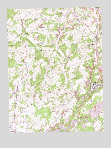
Clymer, PA USGS Topographic Map
Click on map above to begin viewing in our Map Viewer.

This topographic map contains these locations and features:
Feature Name Type Latitude Longitude GNIS ID View Map
Allen BridgeBridgeN40.6284°W79.0592°1168180View Map
Allen RunStreamN40.6270°W79.0578°1168186View Map
Barr SlopePopulated PlaceN40.7131°W79.0159°1168753View Map
Bethel ChurchChurchN40.7265°W79.0220°1169394View Map
Borough of ClymerCivilN40.6686°W79.0133°1215285View Map
Brush RunStreamN40.7223°W79.0970°1170453View Map
Buck RunStreamN40.6726°W79.0031°1170550View Map
Cherry Hill Progressive Brethren CemeteryCemeteryN40.6397°W79.0646°1171687View Map
ClymerPopulated PlaceN40.6681°W79.0117°1172042View Map
Clymer Borough Police DepartmentBuildingN40.6689°W79.0125°2781059View Map
Clymer Post OfficePost OfficeN40.6665°W79.0131°2772638View Map
Clymer Volunteer Fire Department Station 150BuildingN40.6697°W79.0122°2645594View Map
Columbia CemeteryCemeteryN40.6985°W79.0458°1172243View Map
DicksonvillePopulated PlaceN40.7162°W79.0073°1852857View Map
Dicksonville Census Designated PlaceCensusN40.7153°W79.0105°2389407View Map
Dixon RunStreamN40.6678°W79.0150°1173319View Map
DixonvillePopulated PlaceN40.7165°W79.0070°1173320View Map
Dixonville Post OfficePost OfficeN40.7177°W79.0067°2773119View Map
GaibltonPopulated PlaceN40.7248°W79.1014°1175378View Map
GilpinPopulated PlaceN40.7084°W79.1000°1175626View Map
Grove ChapelChurchN40.6967°W79.1034°1176271View Map
HomePopulated PlaceN40.7395°W79.1053°1177315View Map
Home Post OfficePost OfficeN40.7396°W79.1061°2779820View Map
IdamarPopulated PlaceN40.7290°W79.0028°1177682View Map
IdealPopulated PlaceN40.6331°W79.0681°1203868View Map
Indiana CountyCivilN40.6520°W79.0875°1213673View Map
Indiana County Airport/Jimmy Stewart FieldAirportN40.6319°W79.1000°1194053View Map
Indiana Wesleyan SchoolSchoolN40.7198°W79.0070°1177798View Map
KellysburgLocaleN40.7353°W79.1053°1201002View Map
KintersburgPopulated PlaceN40.7153°W79.0789°1178528View Map
Kintersburg Covered BridgeBridgeN40.7137°W79.0806°1178529View Map
Musser Forests DamDamN40.6917°W79.0981°1194988View Map
Musser Forests LakeReservoirN40.6936°W79.0984°1194989View Map
OnbergPopulated PlaceN40.6670°W79.0550°1204331View Map
Penn RunStreamN40.6384°W79.0378°1183486View Map
Pine RunStreamN40.7223°W79.1020°1183892View Map
RaynePopulated PlaceN40.7381°W79.0300°1204466View Map
Rayne AirportAirportN40.7327°W79.0662°1194084View Map
Rayne ChurchChurchN40.6912°W79.0698°1199359View Map
Rayne RunStreamN40.7131°W79.0600°1184727View Map
RembrantPopulated PlaceN40.6953°W79.0089°1184891View Map
Rich Hill CemeteryCemeteryN40.6497°W79.0077°1184996View Map
Ruffner ChurchChurchN40.6784°W79.0464°1185604View Map
Sample RunPopulated PlaceN40.6606°W79.0231°1186893View Map
Sample Run CemeteryCemeteryN40.6667°W79.0306°1186894View Map
State Correctional Institution Pine GroveBuildingN40.6477°W79.1015°2757221View Map
TanomaPopulated PlaceN40.7003°W79.0456°1189268View Map
Township of CherryhillCivilN40.6331°W79.0075°1216539View Map
Township of RayneCivilN40.7105°W79.0882°1216548View Map
WeimerPopulated PlaceN40.6901°W79.0184°1199757View Map

Note: Coordinates in the location and feature list above are referenced to NAD83 datum.


Copyright (C) 2008-2024 Ryan Niemi / Sunset Dynamics ... All Rights Reserved