TopoQuest Logo
Do you find TopoQuest useful?
Help keep TopoQuest running and adding new maps/features by donating!
Bitcoin:  19c7KJd3qBynnjoSw5npx9KScwjBe4ifkT
Litecoin:  LXs6TkuXGGXo1vDsWCkWVdjQX94eUKd6ui
Home View Maps Find Maps Find Places Resources & Links


Clymer, New York Topographic Map

USGS Map Title: Clymer, NY
USGS Map MRC: 42079A6
DRG (GeoTIFF) Download: o42079a6.tif


Neighboring USGS Topographic Map Quads:


  North East, PA  
42079B7
 

  South Ripley, NY  
42079B6
 

  Sherman, NY  
42079B5
 

  Wattsburg, PA  
42079A7
 

  Clymer, NY  
42079A6
 

  North Clymer, NY  
42079A5
 

  Union City, PA  
41079H7
 

  Corry, PA  
41079H6
 

  Columbus, PA  
41079H5


Map MRC Location:

N43°
W80°
N43°
W79°
H8 H7 H6 H5 H4 H3 H2 H1
G8 G7 G6 G5 G4 G3 G2 G1
F8 F7 F6 F5 F4 F3 F2 F1
E8 E7 E6 E5 E4 E3 E2 E1
D8 D7 D6 D5 D4 D3 D2 D1
C8 C7 C6 C5 C4 C3 C2 C1
B8 B7 B6 B5 B4 B3 B2 B1
A8 A7 A6 A5 A4 A3 A2 A1
N42°
W80°
N42°
W79°

Clymer, NY USGS 1:24K Topographic Map Preview:
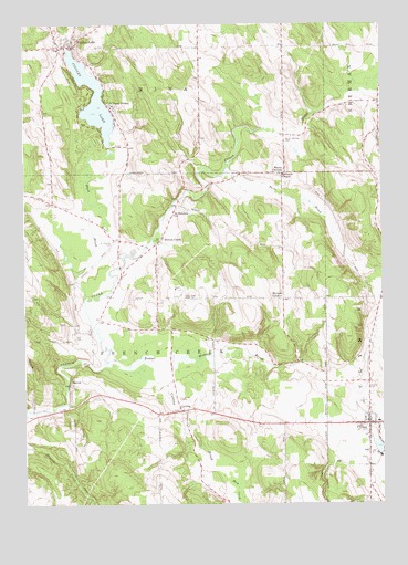
Clymer, NY USGS Topographic Map
Click on map above to begin viewing in our Map Viewer.

This topographic map contains these locations and features:
Feature Name Type Latitude Longitude GNIS ID View Map
Abbe Reformed ChurchChurchN42.0228°W79.6303°2615488View Map
Alder Bottom CreekStreamN42.1073°W79.6259°942264View Map
Alexander Findley Community LibraryBuildingN42.1238°W79.7318°2617205View Map
Beaver Meadow BrookStreamN42.0359°W79.7212°943401View Map
Black BrookStreamN42.0542°W79.7281°944079View Map
Boozel FarmsLocaleN42.0847°W79.7442°2704013View Map
Cabhi FarmLocaleN42.0217°W79.6650°2704010View Map
Camp FindleyLocaleN42.1051°W79.7187°945582View Map
ClymerPopulated PlaceN42.0209°W79.6301°946943View Map
Clymer - French Creek Free LibraryBuildingN42.0215°W79.6297°2617250View Map
Clymer Central SchoolSchoolN42.0214°W79.6266°2669002View Map
Clymer Fire DepartmentBuildingN42.0210°W79.6310°2734683View Map
Clymer Post OfficePost OfficeN42.0207°W79.6293°2617870View Map
CuttingPopulated PlaceN42.0242°W79.6959°947971View Map
Cutting BrookStreamN42.0356°W79.7137°947972View Map
Cutting CemeteryCemeteryN42.0241°W79.6942°2554272View Map
Cutting Community ChurchChurchN42.0241°W79.6948°2615834View Map
Dunnewold FarmsLocaleN42.0253°W79.6853°2704007View Map
Edwards ChapelChurchN42.0859°W79.6595°949407View Map
Findlay Lake Volunteer Fire DepartmentBuildingN42.1194°W79.7332°2700977View Map
Findley LakeLakeN42.1060°W79.7257°950063View Map
Findley LakePopulated PlaceN42.1192°W79.7325°950064View Map
Findley Lake CemeteryCemeteryN42.1192°W79.7380°2554271View Map
Findley Lake Post OfficePost OfficeN42.1198°W79.7348°2617917View Map
Findley Lake United Methodist ChurchChurchN42.1230°W79.7310°2615940View Map
French CreekPopulated PlaceN42.0678°W79.7037°950688View Map
French Creek BridgeBridgeN42.0620°W79.7165°2614908View Map
Herrick CreekStreamN42.0001°W79.7276°1192605View Map
Holland CemeteryCemeteryN42.0295°W79.6292°952988View Map
Lathrup GulfValleyN42.0117°W79.6362°955072View Map
Marks CornersLocaleN42.0862°W79.6598°956540View Map
Marks Corners CemeteryCemeteryN42.0947°W79.6584°956541View Map
MarvinPopulated PlaceN42.0314°W79.7345°956607View Map
Morgan CornersPopulated PlaceN42.0537°W79.6595°957659View Map
North Clymer United Methodist ChurchChurchN42.0215°W79.6303°2616148View Map
Paradise Bay ParkLocaleN42.0999°W79.7289°2615227View Map
Parks BrookStreamN42.0867°W79.6798°959916View Map
Pineview SchoolSchoolN42.0546°W79.6294°2669080View Map
Saint Matthias CemeteryCemeteryN42.0683°W79.7183°964001View Map
Saint Matthias ChurchChurchN42.0756°W79.6975°964002View Map
Taft CemeteryCemeteryN42.0437°W79.7323°966990View Map
Town of French CreekCivilN42.0427°W79.7033°978977View Map
Willink FarmsLocaleN42.0519°W79.7075°2704003View Map

Note: Coordinates in the location and feature list above are referenced to NAD83 datum.


Copyright (C) 2008-2024 Ryan Niemi / Sunset Dynamics ... All Rights Reserved