TopoQuest Logo
Do you find TopoQuest useful?
Help keep TopoQuest running and adding new maps/features by donating!
Bitcoin:  19c7KJd3qBynnjoSw5npx9KScwjBe4ifkT
Litecoin:  LXs6TkuXGGXo1vDsWCkWVdjQX94eUKd6ui
Home View Maps Find Maps Find Places Resources & Links


Colchester, Connecticut Topographic Map

USGS Map Title: Colchester, CT
USGS Map MRC: 41072E3
DRG (GeoTIFF) Download: o41072e3.tif


Neighboring USGS Topographic Map Quads:


  Marlborough, CT  
41072F4
 

  Columbia, CT  
41072F3
 

  Willimantic, CT  
41072F2
 

  Moodus, CT  
41072E4
 

  Colchester, CT  
41072E3
 

  Fitchville, CT  
41072E2
 

  Deep River, CT  
41072D4
 

  Hamburg, CT  
41072D3
 

  Palmertown, CT  
41072D2


Map MRC Location:

N42°
W73°
N42°
W72°
H8 H7 H6 H5 H4 H3 H2 H1
G8 G7 G6 G5 G4 G3 G2 G1
F8 F7 F6 F5 F4 F3 F2 F1
E8 E7 E6 E5 E4 E3 E2 E1
D8 D7 D6 D5 D4 D3 D2 D1
C8 C7 C6 C5 C4 C3 C2 C1
B8 B7 B6 B5 B4 B3 B2 B1
A8 A7 A6 A5 A4 A3 A2 A1
N41°
W73°
N41°
W72°

Colchester, CT USGS 1:24K Topographic Map Preview:
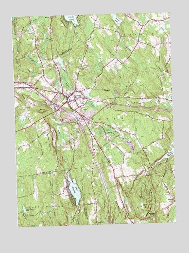
Colchester, CT USGS Topographic Map
Click on map above to begin viewing in our Map Viewer.

This topographic map contains these locations and features:
Feature Name Type Latitude Longitude GNIS ID View Map
Avery CornerPopulated PlaceN41.5176°W72.2542°212411View Map
Bacon AcademySchoolN41.5745°W72.3023°1930596View Map
Bartlett BrookStreamN41.5809°W72.2501°205286View Map
Big BrookStreamN41.5023°W72.2876°205488View Map
Brainard BrookStreamN41.5387°W72.2542°205680View Map
Brewster PondLakeN41.6219°W72.2923°205712View Map
Brewster Pond DamDamN41.6226°W72.2926°1771262View Map
Buckley HillSummitN41.5501°W72.3498°205799View Map
Cabin BrookStreamN41.5601°W72.3409°205908View Map
Chanticlair Golf CourseLocaleN41.5876°W72.3456°1930710View Map
Cherry CornersLocaleN41.5440°W72.2742°206217View Map
Cockle HillSummitN41.5107°W72.2765°206350View Map
Cockle Hill CemeteryCemeteryN41.5145°W72.2745°1930743View Map
ColchesterPopulated PlaceN41.5757°W72.3320°206361View Map
Colchester Assembly of God ChurchChurchN41.5790°W72.3404°1930748View Map
Colchester Bible Baptist ChurchChurchN41.5734°W72.3048°1930749View Map
Colchester Burying Ground CemeteryCemeteryN41.5731°W72.3329°1931334View Map
Colchester Census Designated PlaceCensusN41.5778°W72.3329°2378348View Map
Colchester Federated ChurchChurchN41.5734°W72.3326°1930750View Map
Colchester Fire Marshal's OfficeBuildingN41.5760°W72.3286°2419981View Map
Colchester Hayward Volunteer Fire Company Station 1 HeadquartersBuildingN41.5797°W72.3401°2419965View Map
Colchester Intermediate SchoolSchoolN41.5751°W72.3195°1930751View Map
Colchester Police DepartmentBuildingN41.5760°W72.3287°2754673View Map
Colchester Post OfficePost OfficeN41.5732°W72.3316°1930752View Map
Colchester Town HallBuildingN41.5751°W72.3267°1930753View Map
Connecticut State Patrol Department Troop KBuildingN41.5789°W72.3390°2754667View Map
Cragin Memorial LibraryBuildingN41.5757°W72.3337°1930782View Map
Deep River ReservoirReservoirN41.5445°W72.2508°206652View Map
Dutton SwampSwampN41.5554°W72.3028°206768View Map
East Haddam Fire Company 3 HaywardvilleBuildingN41.5087°W72.3271°2656261View Map
Elisha BrookLakeN41.5936°W72.3170°206924View Map
ExeterPopulated PlaceN41.6198°W72.2642°212456View Map
Exeter BrookStreamN41.5918°W72.2606°206986View Map
Exeter CemeteryCemeteryN41.5671°W72.2674°1931042View Map
Gilletts BrookStreamN41.5820°W72.3684°207309View Map
Golden Hill Paugussett ReservationCivilN41.5522°W72.2680°1930930View Map
Hall BrookStreamN41.5748°W72.2842°207605View Map
Halls HillSummitN41.5687°W72.3204°207624View Map
Harvey PondLakeN41.5284°W72.2726°207704View Map
HaywardvillePopulated PlaceN41.5112°W72.3254°1924197View Map
Heilwield CornerPopulated PlaceN41.5129°W72.2506°212477View Map
Interchange 17CrossingN41.5818°W72.3587°1931024View Map
Interchange 18CrossingN41.5701°W72.3384°1931025View Map
Interchange 19CrossingN41.5590°W72.3245°1931026View Map
Interchange 20CrossingN41.5626°W72.3167°1931027View Map
Interchange 21CrossingN41.5718°W72.2981°1931028View Map
Interchange 5CrossingN41.5015°W72.3023°1931021View Map
Interchange 6CrossingN41.5248°W72.3217°1931022View Map
Jack Jackter Elementary SchoolSchoolN41.5723°W72.3209°1931059View Map
Judd BrookStreamN41.6009°W72.3740°208209View Map
Lake HaywardReservoirN41.5206°W72.3292°207749View Map
Linwood CemeteryCemeteryN41.5700°W72.3408°208491View Map
Long HillSummitN41.5132°W72.3354°208557View Map
Long Pond CemeteryCemeteryN41.5187°W72.3456°208577View Map
McDonald PondReservoirN41.5465°W72.2836°1931182View Map
McDonald SwampSwampN41.5509°W72.2879°208792View Map
Milestone CornerPopulated PlaceN41.5151°W72.2748°212504View Map
Mill HillSummitN41.5690°W72.3542°208903View Map
Nelkin BrookStreamN41.5601°W72.3409°209207View Map
Pecks MeadowSwampN41.5123°W72.3723°1924035View Map
Pecks Meadow PondLakeN41.5103°W72.3694°209686View Map
Pecks Meadow Pond DamDamN41.5098°W72.3687°1770883View Map
Plants PondReservoirN41.5103°W72.2635°1770504View Map
Rattlesnake LedgesBenchN41.5070°W72.2704°210113View Map
Raymond BrookStreamN41.6126°W72.3718°210122View Map
Saint Andrews ChurchChurchN41.5743°W72.3273°1931472View Map
Saint Johns CemeteryCemeteryN41.5951°W72.3404°210452View Map
Saint Marys Ukranian ChurchChurchN41.5715°W72.3370°1931491View Map
Salem Volunteer Fire CompanyBuildingN41.5017°W72.2841°2419975View Map
Skis Landing AreaAirportN41.5731°W72.3017°213023View Map
Strongs PondReservoirN41.5703°W72.3450°1931586View Map
The WalesLocaleN41.5187°W72.2690°211437View Map
Town of ColchesterCivilN41.5621°W72.3475°213409View Map
Upper Millpond DamDamN41.5098°W72.3092°1770997View Map
Whittlesey SwampSwampN41.5095°W72.2674°212107View Map
William J Johnston SchoolSchoolN41.5743°W72.3226°1931719View Map
Witch Meadow BrookStreamN41.5018°W72.2881°212210View Map
Witch Meadow Pond DamDamN41.5001°W72.2962°1771453View Map

Note: Coordinates in the location and feature list above are referenced to NAD83 datum.


Copyright (C) 2008-2024 Ryan Niemi / Sunset Dynamics ... All Rights Reserved