TopoQuest Logo
Do you find TopoQuest useful?
Help keep TopoQuest running and adding new maps/features by donating!
Bitcoin:  19c7KJd3qBynnjoSw5npx9KScwjBe4ifkT
Litecoin:  LXs6TkuXGGXo1vDsWCkWVdjQX94eUKd6ui
Home View Maps Find Maps Find Places Resources & Links


Columbia, Connecticut Topographic Map

USGS Map Title: Columbia, CT
USGS Map MRC: 41072F3
DRG (GeoTIFF) Download: o41072f3.tif


Neighboring USGS Topographic Map Quads:


  Rockville, CT  
41072G4
 

  Coventry, CT  
41072G3
 

  Spring Hill, CT  
41072G2
 

  Marlborough, CT  
41072F4
 

  Columbia, CT  
41072F3
 

  Willimantic, CT  
41072F2
 

  Moodus, CT  
41072E4
 

  Colchester, CT  
41072E3
 

  Fitchville, CT  
41072E2


Map MRC Location:

N42°
W73°
N42°
W72°
H8 H7 H6 H5 H4 H3 H2 H1
G8 G7 G6 G5 G4 G3 G2 G1
F8 F7 F6 F5 F4 F3 F2 F1
E8 E7 E6 E5 E4 E3 E2 E1
D8 D7 D6 D5 D4 D3 D2 D1
C8 C7 C6 C5 C4 C3 C2 C1
B8 B7 B6 B5 B4 B3 B2 B1
A8 A7 A6 A5 A4 A3 A2 A1
N41°
W73°
N41°
W72°

Columbia, CT USGS 1:24K Topographic Map Preview:
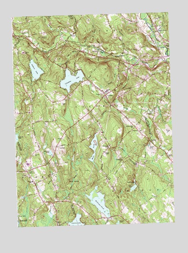
Columbia, CT USGS Topographic Map
Click on map above to begin viewing in our Map Viewer.

This topographic map contains these locations and features:
Feature Name Type Latitude Longitude GNIS ID View Map
AmstonPopulated PlaceN41.6254°W72.3431°205090View Map
Amston LakeReservoirN41.6254°W72.3276°205091View Map
Amston Lake DamDamN41.6270°W72.3345°1771243View Map
Amston Post OfficePost OfficeN41.6291°W72.3440°2783252View Map
AndoverPopulated PlaceN41.7373°W72.3704°205094View Map
Andover Elementary SchoolSchoolN41.7287°W72.3662°205097View Map
Andover LakeReservoirN41.7180°W72.3570°205095View Map
Andover Lake DamDamN41.7244°W72.3600°1771396View Map
Andover Police DepartmentBuildingN41.7284°W72.3682°2754683View Map
Andover Road CemeteryCemeteryN41.6684°W72.3606°205096View Map
Andover Volunteer Fire DepartmentBuildingN41.7287°W72.3689°2420009View Map
Annie E Vinton Elementary SchoolSchoolN41.7465°W72.2592°211751View Map
Bear Swamp BrookStreamN41.7387°W72.3356°212606View Map
Brousseous BrookStreamN41.6604°W72.2795°205763View Map
Brousseous PondLakeN41.6711°W72.3004°205764View Map
Bunker HillSummitN41.7373°W72.3459°205836View Map
Cheney BrookStreamN41.7320°W72.3534°206212View Map
Chesborough BridgeBridgeN41.6629°W72.2898°206223View Map
Chestnut HillLocaleN41.6734°W72.2673°206236View Map
Chestnut HillSummitN41.6809°W72.2767°206242View Map
Chestnut Hill SchoolSchoolN41.6829°W72.2798°206253View Map
Cider Mill BrookStreamN41.7373°W72.2623°212614View Map
Clarks BrookStreamN41.7159°W72.2845°206307View Map
Clarks HillSummitN41.6673°W72.3037°206311View Map
ColumbiaPopulated PlaceN41.7020°W72.3012°206390View Map
Columbia CemeteryCemeteryN41.7024°W72.3050°206391View Map
Columbia LakeReservoirN41.7118°W72.3289°206392View Map
Columbia Lake BrookStreamN41.6965°W72.3317°206393View Map
Columbia Lake DamDamN41.7186°W72.3322°1771196View Map
Columbia Resident State Patrol OfficeBuildingN41.7104°W72.3211°2754765View Map
Columbia Volunteer Fire DepartmentBuildingN41.7023°W72.2995°2420058View Map
Cooks HillSummitN41.6790°W72.2545°206436View Map
Dam BrookStreamN41.6929°W72.2951°206577View Map
Fox IslandIslandN41.6398°W72.3076°1930885View Map
Fresh Air CampLocaleN41.6495°W72.2801°207208View Map
Frog Plain IslandIslandN41.6429°W72.3131°1930900View Map
Giffords BrookStreamN41.6912°W72.2745°207293View Map
Graves PondLakeN41.6600°W72.2788°207423View Map
HebronPopulated PlaceN41.6579°W72.3659°207762View Map
Hebron Elementary SchoolSchoolN41.6520°W72.3620°207764View Map
Hebron Volunteer Fire Department Station 1BuildingN41.6587°W72.3622°2420163View Map
Hebron Volunteer Fire Department Station 2BuildingN41.6265°W72.3351°2420164View Map
Holbrook Pond DamDamN41.6768°W72.3745°1771245View Map
Hop RiverLocaleN41.7279°W72.3056°207939View Map
Horace W Porter Elementary SchoolSchoolN41.7043°W72.3006°209948View Map
Leonard Bridge Station (historical)LocaleN41.6520°W72.3031°1931124View Map
Leonards BridgeBridgeN41.6526°W72.3029°208445View Map
Liberty HillPopulated PlaceN41.6657°W72.2548°208455View Map
Macht BrookStreamN41.7218°W72.2826°208660View Map
Mathiew PondReservoirN41.6371°W72.2967°1771271View Map
Mathiew Pond DamDamN41.6351°W72.2945°1771270View Map
Metenosky Aviation Field (historical)AirportN41.7482°W72.2937°213026View Map
Mint BrookStreamN41.6440°W72.3445°208961View Map
Mono PondReservoirN41.6708°W72.3129°209000View Map
Mono Pond DamDamN41.6789°W72.3113°1770688View Map
Nutmeg Vineyard and WineryLocaleN41.7432°W72.3340°1943281View Map
Palmer PondLakeN41.6710°W72.2687°209599View Map
Parker BridgeBridgeN41.7382°W72.3267°209621View Map
Perkins CornerPopulated PlaceN41.7395°W72.2595°212542View Map
Post HillSummitN41.6715°W72.3384°209955View Map
Robinson PondLakeN41.6687°W72.3472°210243View Map
Rufus BrookStreamN41.7337°W72.3231°212649View Map
Saint Peters CemeteryCemeteryN41.6555°W72.3654°210566View Map
Skoog BrookStreamN41.7133°W72.3550°2501778View Map
Spinning Mill BrookStreamN41.6951°W72.2612°211064View Map
Staddle BrookStreamN41.7398°W72.3687°211119View Map
Stiles PondLakeN41.6470°W72.2819°211183View Map
Stiles Pond DamDamN41.6473°W72.2812°1771257View Map
Theims BrookStreamN41.7320°W72.3156°211438View Map
Thornton BrookStreamN41.7251°W72.2851°211456View Map
Town of ColumbiaCivilN41.6939°W72.3072°213411View Map
Utley HillSummitN41.6962°W72.3356°211714View Map
Utley Hill CemeteryCemeteryN41.6999°W72.3353°211715View Map
Waters Edge CampgroundLocaleN41.6401°W72.2959°1931692View Map
Wells WoodsLocaleN41.6512°W72.3292°211904View Map
Williams PondReservoirN41.6380°W72.3096°212146View Map
Williams Pond DamDamN41.6298°W72.3006°1771255View Map
Willimantic RiverStreamN41.6298°W72.3009°212664View Map

Note: Coordinates in the location and feature list above are referenced to NAD83 datum.


Copyright (C) 2008-2024 Ryan Niemi / Sunset Dynamics ... All Rights Reserved