TopoQuest Logo
Do you find TopoQuest useful?
Help keep TopoQuest running and adding new maps/features by donating!
Bitcoin:  19c7KJd3qBynnjoSw5npx9KScwjBe4ifkT
Litecoin:  LXs6TkuXGGXo1vDsWCkWVdjQX94eUKd6ui
Home View Maps Find Maps Find Places Resources & Links


Columbia, Kentucky Topographic Map

USGS Map Title: Columbia, KY
USGS Map MRC: 37085A3
DRG (GeoTIFF) Download: o37085a3.tif


Neighboring USGS Topographic Map Quads:


  Gresham, KY  
37085B4
 

  Cane Valley, KY  
37085B3
 

  Knifley, KY  
37085B2
 

  Gradyville, KY  
37085A4
 

  Columbia, KY  
37085A3
 

  Montpelier, KY  
37085A2
 

  Breeding, KY  
36085H4
 

  Amandaville, KY  
36085H3
 

  Creelsboro, KY  
36085H2


Map MRC Location:

N38°
W86°
N38°
W85°
H8 H7 H6 H5 H4 H3 H2 H1
G8 G7 G6 G5 G4 G3 G2 G1
F8 F7 F6 F5 F4 F3 F2 F1
E8 E7 E6 E5 E4 E3 E2 E1
D8 D7 D6 D5 D4 D3 D2 D1
C8 C7 C6 C5 C4 C3 C2 C1
B8 B7 B6 B5 B4 B3 B2 B1
A8 A7 A6 A5 A4 A3 A2 A1
N37°
W86°
N37°
W85°

Columbia, KY USGS 1:24K Topographic Map Preview:
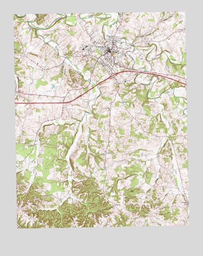
Columbia, KY USGS Topographic Map
Click on map above to begin viewing in our Map Viewer.

This topographic map contains these locations and features:
Feature Name Type Latitude Longitude GNIS ID View Map
Adair CountyCivilN37.1042°W85.2806°516847View Map
Adair County Ambulance ServiceBuildingN37.0972°W85.2958°2719074View Map
Adair County Sheriff's OfficeBuildingN37.1028°W85.3061°2767424View Map
Adair Regional Juvenile Detention CenterBuildingN37.0851°W85.3053°2767716View Map
Adair SchoolSchoolN37.1056°W85.3186°485748View Map
Adair Youth Development Center SchoolSchoolN37.0851°W85.3043°2767712View Map
BlissPopulated PlaceN37.0801°W85.3719°507525View Map
Brush CreekStreamN37.0617°W85.3280°488075View Map
Bull Run CreekStreamN37.1059°W85.2894°488364View Map
Butler BranchStreamN37.1228°W85.2988°488506View Map
Butler Branch (historical)Populated PlaceN37.1237°W85.2953°2743186View Map
Casey SchoolSchoolN37.1056°W85.3225°489051View Map
Casey Spring (historical)SpringN37.0802°W85.3723°2743192View Map
City of ColumbiaCivilN37.1035°W85.3073°2404105View Map
City of Columbia Fire DepartmentBuildingN37.1045°W85.3056°2637336View Map
ColumbiaPopulated PlaceN37.1028°W85.3064°489885View Map
Columbia - Adair County Fire DepartmentBuildingN37.1052°W85.3089°2637011View Map
Columbia DivisionCivilN37.0835°W85.3026°1936943View Map
Columbia Police DepartmentBuildingN37.1033°W85.3051°2767434View Map
Columbia-Adair County AirportAirportN37.0851°W85.3472°517356View Map
Earl RidgeRidgeN37.0051°W85.3119°491417View Map
FairplayPopulated PlaceN37.0123°W85.3039°507971View Map
FlatwoodPopulated PlaceN37.0478°W85.3616°508008View Map
Gadberry (historical)Populated PlaceN37.0437°W85.3094°508057View Map
GarlinPopulated PlaceN37.1140°W85.2522°492704View Map
Glens ForkPopulated PlaceN37.0140°W85.2505°492906View Map
Glens ForkStreamN37.0742°W85.2733°492907View Map
Green HillsPopulated PlaceN37.0998°W85.2836°2743207View Map
Gum GrovePopulated PlaceN37.0046°W85.2736°2743212View Map
Hunter (historical)Populated PlaceN37.0692°W85.3401°2743385View Map
Kentucky State Police Post 15BuildingN37.0896°W85.3045°2767680View Map
Lindsey Wilson CollegeSchoolN37.1026°W85.3002°496575View Map
Longview (historical)Populated PlaceN37.0786°W85.3001°2743387View Map
Loy BranchStreamN37.0403°W85.2727°497326View Map
New Columbia CemeteryCemeteryN37.1084°W85.2816°499303View Map
New Zion ChurchChurchN37.0342°W85.3111°499415View Map
Pelham Branch (historical)Populated PlaceN37.1052°W85.3439°2743400View Map
Pettys ForkStreamN37.1161°W85.3581°500492View Map
Pierce ChapelChurchN37.0204°W85.2901°500573View Map
Santa Fee ChurchChurchN37.0490°W85.3616°502990View Map
Smith ChapelChurchN37.0420°W85.3100°503772View Map
South Columbia (historical)Populated PlaceN37.0810°W85.3330°2743410View Map
Sulphur CreekStreamN37.1042°W85.2875°504734View Map
Tabor (historical)Populated PlaceN37.0590°W85.3066°2743412View Map
WAIN-AM (Columbia)TowerN37.1101°W85.2783°517581View Map
WAIN-FM (Columbia)TowerN37.1101°W85.2783°517687View Map
West Prong Glens ForkStreamN37.0506°W85.2650°506471View Map
Westlake Regional HospitalHospitalN37.0966°W85.2944°2660339View Map
Zion ChurchChurchN37.0506°W85.2622°507279View Map

Note: Coordinates in the location and feature list above are referenced to NAD83 datum.


Copyright (C) 2008-2024 Ryan Niemi / Sunset Dynamics ... All Rights Reserved