TopoQuest Logo
Do you find TopoQuest useful?
Help keep TopoQuest running and adding new maps/features by donating!
Bitcoin:  19c7KJd3qBynnjoSw5npx9KScwjBe4ifkT
Litecoin:  LXs6TkuXGGXo1vDsWCkWVdjQX94eUKd6ui
Home View Maps Find Maps Find Places Resources & Links


Knifley, Kentucky Topographic Map

USGS Map Title: Knifley, KY
USGS Map MRC: 37085B2
DRG (GeoTIFF) Download: o37085b2.tif


Neighboring USGS Topographic Map Quads:


  Campbellsville, KY  
37085C3
 

  Mannsville, KY  
37085C2
 

  Clementsville, KY  
37085C1
 

  Cane Valley, KY  
37085B3
 

  Knifley, KY  
37085B2
 

  Dunnville, KY  
37085B1
 

  Columbia, KY  
37085A3
 

  Montpelier, KY  
37085A2
 

  Russell Springs, KY  
37085A1


Map MRC Location:

N38°
W86°
N38°
W85°
H8 H7 H6 H5 H4 H3 H2 H1
G8 G7 G6 G5 G4 G3 G2 G1
F8 F7 F6 F5 F4 F3 F2 F1
E8 E7 E6 E5 E4 E3 E2 E1
D8 D7 D6 D5 D4 D3 D2 D1
C8 C7 C6 C5 C4 C3 C2 C1
B8 B7 B6 B5 B4 B3 B2 B1
A8 A7 A6 A5 A4 A3 A2 A1
N37°
W86°
N37°
W85°

Knifley, KY USGS 1:24K Topographic Map Preview:
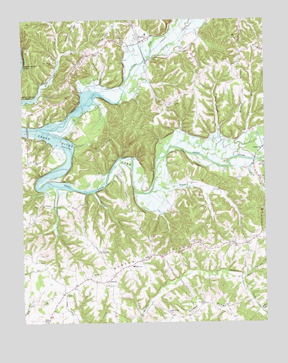
Knifley, KY USGS Topographic Map
Click on map above to begin viewing in our Map Viewer.

This topographic map contains these locations and features:
Feature Name Type Latitude Longitude GNIS ID View Map
Absher CemeteryCemeteryN37.1728°W85.2416°485739View Map
Allen CemeteryCemeteryN37.2281°W85.1608°485855View Map
Bearwallow ChurchChurchN37.1442°W85.2147°486592View Map
Beulah ChapelChurchN37.1256°W85.2380°487051View Map
Blair RidgeRidgeN37.2401°W85.1344°487441View Map
Bloomington ChapelChurchN37.1542°W85.2094°487500View Map
Blue BranchStreamN37.1931°W85.1407°487508View Map
Blue HollowValleyN37.2034°W85.1339°2743181View Map
Bryant CreekStreamN37.1795°W85.1833°488167View Map
Caldwell ChurchChurchN37.2317°W85.1397°488590View Map
Casey CreekStreamN37.2157°W85.2004°485672View Map
Casey Creek DivisionCivilN37.2383°W85.1624°1936923View Map
ChristinePopulated PlaceN37.1423°W85.2069°507700View Map
Crooked CreekStreamN37.2342°W85.1833°490378View Map
Damron CemeteryCemeteryN37.1867°W85.1994°490549View Map
Denton BranchStreamN37.1792°W85.2130°490820View Map
Drye BranchStreamN37.1917°W85.1305°491245View Map
Dunbar CemeteryCemeteryN37.2387°W85.1686°491286View Map
Dunbar HillPopulated PlaceN37.2159°W85.1716°507888View Map
EllaPopulated PlaceN37.1567°W85.1397°507925View Map
Fairview ChurchChurchN37.1537°W85.1330°491913View Map
Grace RidgeRidgeN37.2190°W85.1358°493070View Map
Grassy Springs ChurchChurchN37.1292°W85.1752°493172View Map
Hawk BranchStreamN37.1439°W85.1373°493885View Map
Janice Holt Giles Historical MarkerParkN37.2013°W85.1478°2744128View Map
KnifleyPopulated PlaceN37.2428°W85.1894°508402View Map
Knifley Fire DepartmentBuildingN37.2445°W85.1901°2637013View Map
Little Cake Christian ChurchChurchN37.1826°W85.1638°496654View Map
Lovedale ChurchChurchN37.1328°W85.1563°497216View Map
McKee BranchStreamN37.1298°W85.1275°497891View Map
NeatsvillePopulated PlaceN37.1973°W85.1255°508677View Map
New Hope ChurchChurchN37.1576°W85.1405°499350View Map
Parker Chapel CemeteryCemeteryN37.2326°W85.2336°500191View Map
Plum Point ChurchChurchN37.1917°W85.2469°500973View Map
PurdyPopulated PlaceN37.1515°W85.1850°508885View Map
Robinson ChapelChurchN37.2365°W85.2108°502088View Map
Robinson RidgeRidgeN37.2387°W85.2127°502095View Map
Shepherd SchoolSchoolN37.1484°W85.1930°503348View Map
Snake CreekStreamN37.1809°W85.2319°503839View Map
Spout Springs BranchStreamN37.1976°W85.1708°504093View Map
Stillhouse HollowValleyN37.2253°W85.2122°504419View Map
Tabernacle ChurchChurchN37.1840°W85.1269°504900View Map
VesterLocaleN37.1373°W85.2291°506031View Map
WDCL-FM (Somerset)TowerN37.1581°W85.1638°517740View Map
White Oak DivisionCivilN37.1313°W85.1583°1937316View Map

Note: Coordinates in the location and feature list above are referenced to NAD83 datum.


Copyright (C) 2008-2024 Ryan Niemi / Sunset Dynamics ... All Rights Reserved