TopoQuest Logo
Do you find TopoQuest useful?
Help keep TopoQuest running and adding new maps/features by donating!
Bitcoin:  19c7KJd3qBynnjoSw5npx9KScwjBe4ifkT
Litecoin:  LXs6TkuXGGXo1vDsWCkWVdjQX94eUKd6ui
Home View Maps Find Maps Find Places Resources & Links


Cornelia, Missouri Topographic Map

USGS Map Title: Cornelia, MO
USGS Map MRC: 38093F6
DRG (GeoTIFF) Download: o38093f6.tif


Neighboring USGS Topographic Map Quads:


  Warrensburg West, MO  
38093G7
 

  Warrensburg East, MO  
38093G6
 

  Knob Noster, MO  
38093G5
 

  Centerview, MO  
38093F7
 

  Cornelia, MO  
38093F6
 

  Burtville, MO  
38093F5
 

  Chilhowee, MO  
38093E7
 

  Leeton, MO  
38093E6
 

  Windsor, MO  
38093E5


Map MRC Location:

N39°
W94°
N39°
W93°
H8 H7 H6 H5 H4 H3 H2 H1
G8 G7 G6 G5 G4 G3 G2 G1
F8 F7 F6 F5 F4 F3 F2 F1
E8 E7 E6 E5 E4 E3 E2 E1
D8 D7 D6 D5 D4 D3 D2 D1
C8 C7 C6 C5 C4 C3 C2 C1
B8 B7 B6 B5 B4 B3 B2 B1
A8 A7 A6 A5 A4 A3 A2 A1
N38°
W94°
N38°
W93°

Cornelia, MO USGS 1:24K Topographic Map Preview:
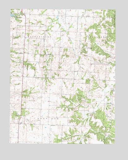
Cornelia, MO USGS Topographic Map
Click on map above to begin viewing in our Map Viewer.

This topographic map contains these locations and features:
Feature Name Type Latitude Longitude GNIS ID View Map
Adams Memorial CemeteryCemeteryN38.7002°W93.6483°713146View Map
Adams School (historical)SchoolN38.7070°W93.6583°713149View Map
AubreyLocaleN38.6681°W93.7027°740247View Map
Aubrey Post Office (historical)Post OfficeN38.6681°W93.7027°745113View Map
Bell BranchStreamN38.6658°W93.6385°713897View Map
Bethel ChurchChurchN38.6995°W93.6502°714059View Map
BowmansvillePopulated PlaceN38.7092°W93.7338°740687View Map
Bristle RidgeRidgeN38.7350°W93.6433°714721View Map
Bristle RidgePopulated PlaceN38.7139°W93.6580°740693View Map
Coperas CreekStreamN38.6758°W93.6291°729725View Map
CorneliaPopulated PlaceN38.6436°W93.7394°729726View Map
Crab Orchard Church (historical)ChurchN38.6618°W93.6282°745135View Map
Crab Orchard School (historical)SchoolN38.6610°W93.6283°745136View Map
Dawson School (historical)SchoolN38.7436°W93.6558°716751View Map
East Bear CreekStreamN38.7403°W93.6944°717251View Map
Epp BranchStreamN38.6386°W93.6547°717615View Map
Fickas CemeteryCemeteryN38.7139°W93.7219°717894View Map
Futurama Lake DamDamN38.7217°W93.7185°763299View Map
Greer CemeteryCemeteryN38.6443°W93.6784°718854View Map
Harmony ChurchChurchN38.6422°W93.7013°719113View Map
Hickory Hills LakeReservoirN38.7433°W93.6619°763160View Map
Hickory Hills Lake DamDamN38.7433°W93.6619°763159View Map
Johnson County Fire Protection District Station 10BuildingN38.7440°W93.7066°2620891View Map
Johnson County Fire Protection District Station 9 CorneliaBuildingN38.6433°W93.7408°2621698View Map
Jones CemeteryCemeteryN38.6863°W93.6566°720409View Map
Kallstrom LakeReservoirN38.6550°W93.6452°763434View Map
Kallstrom Lake DamDamN38.6550°W93.6452°763433View Map
Lone Star School (historical)SchoolN38.6645°W93.6569°745530View Map
Long BranchStreamN38.6577°W93.6502°721498View Map
Memorial GardensCemeteryN38.7266°W93.7334°2702388View Map
Mineral CreekStreamN38.6292°W93.6647°722423View Map
Mount Zion CemeteryCemeteryN38.6731°W93.7347°722932View Map
Mount Zion ChurchChurchN38.6861°W93.7158°722955View Map
Oakland School (historical)SchoolN38.7131°W93.7477°745529View Map
Pertle SpringsPopulated PlaceN38.7328°W93.7316°740248View Map
Pertle SpringsSpringN38.7422°W93.7441°729795View Map
Pertle Springs LakeReservoirN38.7441°W93.7486°762890View Map
Pinnacle HillSummitN38.6525°W93.6580°724416View Map
Roop CemeteryCemeteryN38.7342°W93.7291°725551View Map
Sprout LakeReservoirN38.6733°W93.6985°763101View Map
Sutton CemeteryCemeteryN38.7258°W93.6897°727349View Map
Teefly Lake DamDamN38.6950°W93.7102°763432View Map
Teller Lake DamDamN38.6733°W93.6985°763100View Map
Union Point School (historical)SchoolN38.6675°W93.6994°745528View Map
Valley School (historical)SchoolN38.7078°W93.7013°728102View Map
Warrensburg High SchoolSchoolN38.7405°W93.7109°2545212View Map
West Bear CreekStreamN38.7403°W93.6944°728527View Map

Note: Coordinates in the location and feature list above are referenced to NAD83 datum.


Copyright (C) 2008-2024 Ryan Niemi / Sunset Dynamics ... All Rights Reserved