TopoQuest Logo
Do you find TopoQuest useful?
Help keep TopoQuest running and adding new maps/features by donating!
Bitcoin:  19c7KJd3qBynnjoSw5npx9KScwjBe4ifkT
Litecoin:  LXs6TkuXGGXo1vDsWCkWVdjQX94eUKd6ui
Home View Maps Find Maps Find Places Resources & Links


Burtville, Missouri Topographic Map

USGS Map Title: Burtville, MO
USGS Map MRC: 38093F5
DRG (GeoTIFF) Download: o38093f5.tif


Neighboring USGS Topographic Map Quads:


  Warrensburg East, MO  
38093G6
 

  Knob Noster, MO  
38093G5
 

  La Monte, MO  
38093G4
 

  Cornelia, MO  
38093F6
 

  Burtville, MO  
38093F5
 

  Green Ridge North, MO  
38093F4
 

  Leeton, MO  
38093E6
 

  Windsor, MO  
38093E5
 

  Green Ridge South, MO  
38093E4


Map MRC Location:

N39°
W94°
N39°
W93°
H8 H7 H6 H5 H4 H3 H2 H1
G8 G7 G6 G5 G4 G3 G2 G1
F8 F7 F6 F5 F4 F3 F2 F1
E8 E7 E6 E5 E4 E3 E2 E1
D8 D7 D6 D5 D4 D3 D2 D1
C8 C7 C6 C5 C4 C3 C2 C1
B8 B7 B6 B5 B4 B3 B2 B1
A8 A7 A6 A5 A4 A3 A2 A1
N38°
W94°
N38°
W93°

Burtville, MO USGS 1:24K Topographic Map Preview:
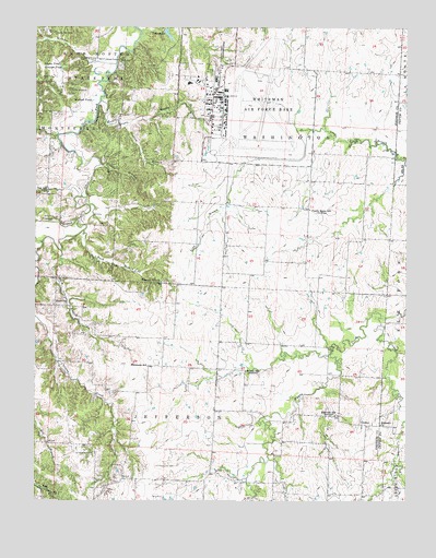
Burtville, MO USGS Topographic Map
Click on map above to begin viewing in our Map Viewer.

This topographic map contains these locations and features:
Feature Name Type Latitude Longitude GNIS ID View Map
Adams PondLakeN38.7397°W93.6172°713147View Map
Brewer BranchStreamN38.7303°W93.6030°714673View Map
Brushy School (historical)SchoolN38.6595°W93.5541°714925View Map
Buck BranchStreamN38.6961°W93.6088°714945View Map
BurtvillePopulated PlaceN38.6764°W93.6185°740713View Map
Camp Bob WhiteLocaleN38.7331°W93.6141°715241View Map
Camp Red CedarLocaleN38.7483°W93.6197°715283View Map
Charles (historical)LocaleN38.6920°W93.5480°740241View Map
Charles Post Office (historical)Post OfficeN38.6920°W93.5480°745130View Map
Crooked CreekStreamN38.6736°W93.5083°716515View Map
Diamond Point School (historical)SchoolN38.7437°W93.6039°745531View Map
Eldorado ChurchChurchN38.6452°W93.5088°717435View Map
Eldorado School (historical)SchoolN38.6478°W93.5241°717438View Map
Ellis CemeteryCemeteryN38.6996°W93.6186°717489View Map
Fair Play School (historical)SchoolN38.7038°W93.5704°745541View Map
Floridonia School (historical)SchoolN38.6606°W93.5872°729741View Map
Graham BranchStreamN38.7242°W93.5952°718653View Map
Gribble BranchStreamN38.7136°W93.6033°718870View Map
Hall Lake DamDamN38.7000°W93.5819°763385View Map
Knob Noster State ParkParkN38.7361°W93.6047°729758View Map
Kranz LakeReservoirN38.7117°W93.5802°763384View Map
Kranz Lake DamDamN38.7117°W93.5802°763383View Map
Lake ButeoLakeN38.7482°W93.5807°715022View Map
Lake Buteo DamDamN38.7467°W93.5819°763074View Map
Lake Sexton AirportAirportN38.6595°W93.6248°758983View Map
Mallard PondLakeN38.7303°W93.6063°721776View Map
McAdoo CreekStreamN38.7400°W93.5983°722022View Map
Number 425 DamDamN38.7217°W93.5752°763163View Map
Oak Hill ChurchChurchN38.7064°W93.6208°729791View Map
OwsleyPopulated PlaceN38.6453°W93.5155°741132View Map
Pleasant Hill ChurchChurchN38.6828°W93.5827°724534View Map
Plum BranchStreamN38.6908°W93.6166°724659View Map
Prairie Home School (historical)SchoolN38.7020°W93.5327°729803View Map
Roberts Hunter Lake DamDamN38.7133°W93.6019°763162View Map
Sexton LakeReservoirN38.6583°W93.6185°762869View Map
Sexton Lake DamDamN38.6583°W93.6185°762868View Map
Shawnee PondLakeN38.7389°W93.6163°726296View Map
Shirley LakeReservoirN38.6268°W93.5523°763382View Map
Shirley Lake DamDamN38.6283°W93.5519°763381View Map
Township of WashingtonCivilN38.7469°W93.5486°766843View Map
Vinegar BranchStreamN38.6989°W93.6110°728207View Map
Whiteman Air Force BaseMilitaryN38.7291°W93.5634°2512392View Map
Whiteman Air Force BaseAirportN38.7308°W93.5554°2679350View Map
Whiteman Air Force Base Census Designated PlaceCensusN38.7302°W93.5589°2393857View Map
Whiteman Air Force Base Elementary SchoolSchoolN38.7365°W93.5763°2545204View Map
Whiteman Air Force Base Fire Emergency ServicesBuildingN38.7247°W93.5646°2620842View Map
Whiteman Air Force Base Post OfficePost OfficeN38.7298°W93.5638°2779467View Map
Woolery School (historical)SchoolN38.7389°W93.5480°745532View Map

Note: Coordinates in the location and feature list above are referenced to NAD83 datum.


Copyright (C) 2008-2025 Ryan Niemi / Sunset Dynamics ... All Rights Reserved