TopoQuest Logo
Do you find TopoQuest useful?
Help keep TopoQuest running and adding new maps/features by donating!
Bitcoin:  19c7KJd3qBynnjoSw5npx9KScwjBe4ifkT
Litecoin:  LXs6TkuXGGXo1vDsWCkWVdjQX94eUKd6ui
Home View Maps Find Maps Find Places Resources & Links


Leeton, Missouri Topographic Map

USGS Map Title: Leeton, MO
USGS Map MRC: 38093E6
DRG (GeoTIFF) Download: o38093e6.tif


Neighboring USGS Topographic Map Quads:


  Centerview, MO  
38093F7
 

  Cornelia, MO  
38093F6
 

  Burtville, MO  
38093F5
 

  Chilhowee, MO  
38093E7
 

  Leeton, MO  
38093E6
 

  Windsor, MO  
38093E5
 

  Clinton North, MO  
38093D7
 

  Calhoun West, MO  
38093D6
 

  Calhoun East, MO  
38093D5


Map MRC Location:

N39°
W94°
N39°
W93°
H8 H7 H6 H5 H4 H3 H2 H1
G8 G7 G6 G5 G4 G3 G2 G1
F8 F7 F6 F5 F4 F3 F2 F1
E8 E7 E6 E5 E4 E3 E2 E1
D8 D7 D6 D5 D4 D3 D2 D1
C8 C7 C6 C5 C4 C3 C2 C1
B8 B7 B6 B5 B4 B3 B2 B1
A8 A7 A6 A5 A4 A3 A2 A1
N38°
W94°
N38°
W93°

Leeton, MO USGS 1:24K Topographic Map Preview:
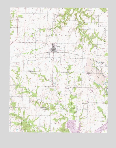
Leeton, MO USGS Topographic Map
Click on map above to begin viewing in our Map Viewer.

This topographic map contains these locations and features:
Feature Name Type Latitude Longitude GNIS ID View Map
Avery CemeteryCemeteryN38.5206°W93.6680°713504View Map
Avery Settlement (historical)LocaleN38.5231°W93.6750°745037View Map
City of LeetonCivilN38.5832°W93.6952°2395670View Map
Cold Springs School (historical)SchoolN38.6174°W93.6381°745538View Map
Fewel CemeteryCemeteryN38.5494°W93.6912°717893View Map
Gladden School (historical)SchoolN38.6178°W93.7424°745536View Map
Groff Lake DamDamN38.5034°W93.7402°763027View Map
Hickory Grove CemeteryCemeteryN38.5229°W93.7017°719457View Map
Hickory Grove ChurchChurchN38.5250°W93.7108°719464View Map
Hickory Grove School (historical)SchoolN38.5245°W93.7108°745457View Map
Johnson County Fire Protection District Station 2 LeetonBuildingN38.5820°W93.6962°2620644View Map
LeetonPopulated PlaceN38.5831°W93.6947°720898View Map
Leeton Elementary SchoolSchoolN38.5882°W93.6962°2545446View Map
Leeton High SchoolSchoolN38.5873°W93.6969°2545165View Map
Leeton Middle SchoolSchoolN38.5877°W93.6964°2545473View Map
Leeton Post OfficePost OfficeN38.5836°W93.6956°2779506View Map
Leeton School (historical)SchoolN38.5725°W93.6416°745537View Map
Lewis CemeteryCemeteryN38.5211°W93.6760°720938View Map
Little Tebo CreekStreamN38.5134°W93.6755°721338View Map
Lone Valley School (historical)SchoolN38.5972°W93.6758°2743994View Map
Mineral Creek CemeteryCemeteryN38.5892°W93.7035°722424View Map
Mineral Valley School (historical)SchoolN38.6041°W93.7029°2743988View Map
New CastlePopulated PlaceN38.5706°W93.6366°741097View Map
Number 106 LakeReservoirN38.5024°W93.7402°763028View Map
Number 131 ReservoirReservoirN38.5062°W93.6606°763045View Map
Pleasant View School (historical)SchoolN38.5292°W93.6510°724650View Map
Salem CemeteryCemeteryN38.5258°W93.6374°725926View Map
Sanctified ChurchChurchN38.5236°W93.6785°725996View Map
Sardis North CemeteryCemeteryN38.5381°W93.6652°726065View Map
Sardis South CemeteryCemeteryN38.5348°W93.6651°726064View Map
Tebo Diversionary Impoundment DamDamN38.5034°W93.6619°763044View Map
Township of Post OakCivilN38.6238°W93.7130°766839View Map
Township of TeboCivilN38.5083°W93.6710°766748View Map
Wade CemeteryCemeteryN38.5308°W93.7183°728231View Map
Washington School (historical)SchoolN38.6228°W93.7027°745245View Map
Wilson LakeReservoirN38.5868°W93.6413°763168View Map
Wilson Lake DamDamN38.5867°W93.6435°763167View Map
Windsor Lake DamDamN38.5317°W93.6869°763437View Map

Note: Coordinates in the location and feature list above are referenced to NAD83 datum.


Copyright (C) 2008-2024 Ryan Niemi / Sunset Dynamics ... All Rights Reserved