TopoQuest Logo
Do you find TopoQuest useful?
Help keep TopoQuest running and adding new maps/features by donating!
Bitcoin:  19c7KJd3qBynnjoSw5npx9KScwjBe4ifkT
Litecoin:  LXs6TkuXGGXo1vDsWCkWVdjQX94eUKd6ui
Home View Maps Find Maps Find Places Resources & Links


Windsor, Missouri Topographic Map

USGS Map Title: Windsor, MO
USGS Map MRC: 38093E5
DRG (GeoTIFF) Download: o38093e5.tif


Neighboring USGS Topographic Map Quads:


  Cornelia, MO  
38093F6
 

  Burtville, MO  
38093F5
 

  Green Ridge North, MO  
38093F4
 

  Leeton, MO  
38093E6
 

  Windsor, MO  
38093E5
 

  Green Ridge South, MO  
38093E4
 

  Calhoun West, MO  
38093D6
 

  Calhoun East, MO  
38093D5
 

  Lincoln NW, MO  
38093D4


Map MRC Location:

N39°
W94°
N39°
W93°
H8 H7 H6 H5 H4 H3 H2 H1
G8 G7 G6 G5 G4 G3 G2 G1
F8 F7 F6 F5 F4 F3 F2 F1
E8 E7 E6 E5 E4 E3 E2 E1
D8 D7 D6 D5 D4 D3 D2 D1
C8 C7 C6 C5 C4 C3 C2 C1
B8 B7 B6 B5 B4 B3 B2 B1
A8 A7 A6 A5 A4 A3 A2 A1
N38°
W94°
N38°
W93°

Windsor, MO USGS 1:24K Topographic Map Preview:
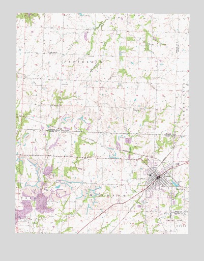
Windsor, MO USGS Topographic Map
Click on map above to begin viewing in our Map Viewer.

This topographic map contains these locations and features:
Feature Name Type Latitude Longitude GNIS ID View Map
Askins CemeteryCemeteryN38.5073°W93.6181°713448View Map
Barber Lake Section 31 DamDamN38.5467°W93.6102°763379View Map
Barber Lake Section 32 DamDamN38.5484°W93.6002°763378View Map
Bell CemeteryCemeteryN38.5132°W93.5038°713901View Map
Berry School (historical)SchoolN38.5186°W93.6049°745458View Map
Big Coal BankMineN38.5217°W93.5986°745039View Map
BowenPopulated PlaceN38.5581°W93.5910°714568View Map
Callaway Lake DamDamN38.5250°W93.5952°763377View Map
Chipman CemeteryCemeteryN38.5247°W93.6013°715796View Map
City of WindsorCivilN38.5319°W93.5227°2397342View Map
Coon CreekStreamN38.5056°W93.6122°716252View Map
Cooper CemeteryCemeteryN38.6004°W93.5728°716278View Map
Elm BranchStreamN38.5005°W93.5296°729734View Map
Farrington ParkParkN38.5297°W93.5102°717859View Map
Ferguson Farms AirportAirportN38.5806°W93.5947°759005View Map
Goodwin CemeteryCemeteryN38.6064°W93.5313°718577View Map
HenriettaPopulated PlaceN38.6025°W93.6188°740275View Map
Henrietta Post Office (historical)Post OfficeN38.6025°W93.6188°745167View Map
High Point ChurchChurchN38.6025°W93.6019°719540View Map
Hillside School (historical)SchoolN38.5711°W93.5405°729751View Map
Hughes School (historical)SchoolN38.5034°W93.5102°745342View Map
Laurel Oak CemeteryCemeteryN38.5225°W93.5205°720836View Map
Liberty ChurchChurchN38.5439°W93.5858°729765View Map
Netsch Lake DamDamN38.5591°W93.6055°763161View Map
Pleasant Green School (historical)SchoolN38.6110°W93.5368°724477View Map
Royal Oaks HospitalHospitalN38.5341°W93.5187°2655040View Map
Sunny Side School (historical)SchoolN38.5722°W93.5938°727301View Map
SutherlandPopulated PlaceN38.5850°W93.5927°741304View Map
Township of JeffersonCivilN38.6200°W93.5736°766835View Map
Township of WindsorCivilN38.5078°W93.5606°766751View Map
Valley Grove School (historical)SchoolN38.6161°W93.5910°728098View Map
Windsoar AirportAirportN38.5435°W93.5076°759004View Map
WindsorPopulated PlaceN38.5322°W93.5222°729832View Map
Windsor Elementary SchoolSchoolN38.5288°W93.5259°745110View Map
Windsor FairgroundParkN38.5406°W93.5060°728992View Map
Windsor Farrington Park LakeReservoirN38.5284°W93.5098°762871View Map
Windsor Farrington Park Lake DamDamN38.5267°W93.5085°762870View Map
Windsor Four County Rural Fire DepartmentBuildingN38.5345°W93.5251°2621553View Map
Windsor High SchoolSchoolN38.5402°W93.5245°2743825View Map
Windsor Post OfficePost OfficeN38.5323°W93.5214°2779446View Map
Woodard CemeteryCemeteryN38.5582°W93.5303°729090View Map
Young Lake DamDamN38.6117°W93.5269°763380View Map

Note: Coordinates in the location and feature list above are referenced to NAD83 datum.


Copyright (C) 2008-2025 Ryan Niemi / Sunset Dynamics ... All Rights Reserved