TopoQuest Logo
Do you find TopoQuest useful?
Help keep TopoQuest running and adding new maps/features by donating!
Bitcoin:  19c7KJd3qBynnjoSw5npx9KScwjBe4ifkT
Litecoin:  LXs6TkuXGGXo1vDsWCkWVdjQX94eUKd6ui
Home View Maps Find Maps Find Places Resources & Links


Angelica, New York Topographic Map

USGS Map Title: Angelica, NY
USGS Map MRC: 42078C1
DRG (GeoTIFF) Download: o42078c1.tif


Neighboring USGS Topographic Map Quads:


  Houghton, NY  
42078D2
 

  Fillmore, NY  
42078D1
 

  Birdsall, NY  
42077D8
 

  Black Creek, NY  
42078C2
 

  Angelica, NY  
42078C1
 

  West Almond, NY  
42077C8
 

  Friendship, NY  
42078B2
 

  Belmont, NY  
42078B1
 

  Wellsville North, NY  
42077B8


Map MRC Location:

N43°
W79°
N43°
W78°
H8 H7 H6 H5 H4 H3 H2 H1
G8 G7 G6 G5 G4 G3 G2 G1
F8 F7 F6 F5 F4 F3 F2 F1
E8 E7 E6 E5 E4 E3 E2 E1
D8 D7 D6 D5 D4 D3 D2 D1
C8 C7 C6 C5 C4 C3 C2 C1
B8 B7 B6 B5 B4 B3 B2 B1
A8 A7 A6 A5 A4 A3 A2 A1
N42°
W79°
N42°
W78°

Angelica, NY USGS 1:24K Topographic Map Preview:
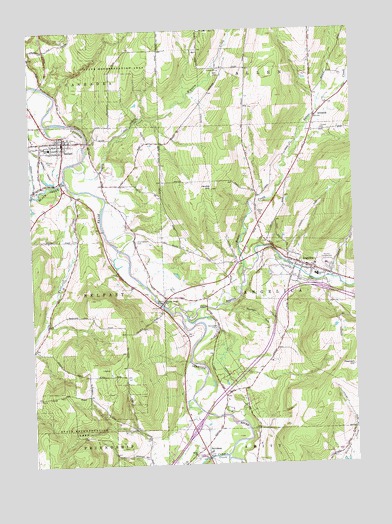
Angelica, NY USGS Topographic Map
Click on map above to begin viewing in our Map Viewer.

This topographic map contains these locations and features:
Feature Name Type Latitude Longitude GNIS ID View Map
Allegany CountyCivilN42.2574°W78.0276°974100View Map
Allegany County LandfillLocaleN42.2616°W78.0329°2668654View Map
Allen CemeteryCemeteryN42.3622°W78.0506°942351View Map
AngelicaPopulated PlaceN42.3067°W78.0158°942478View Map
Angelica CreekStreamN42.2951°W78.0728°942479View Map
Angelica Fire and Rescue DepartmentBuildingN42.3071°W78.0207°2700851View Map
Angelica Free LibraryBuildingN42.3068°W78.0196°2617208View Map
Angelica Park Circle Historic DistrictParkN42.3061°W78.0158°2567503View Map
Angelica Post OfficePost OfficeN42.3062°W78.0170°2617795View Map
Angelica United Methodist ChurchChurchN42.3065°W78.0149°2615532View Map
AristotlePopulated PlaceN42.3498°W78.0139°972175View Map
Baker CreekStreamN42.3051°W78.0431°942829View Map
Bartlett Memorial LibraryBuildingN42.3414°W78.1122°2417978View Map
Basswood Hill FarmLocaleN42.3733°W78.0142°2703672View Map
BelfastPopulated PlaceN42.3428°W78.1114°943574View Map
Belfast Census Designated PlaceCensusN42.3398°W78.1184°2627970View Map
Belfast Fire DepartmentBuildingN42.3443°W78.1111°2417976View Map
Belfast Post OfficePost OfficeN42.3422°W78.1122°2617811View Map
Belfast Town HallBuildingN42.3442°W78.1114°2417977View Map
Belfast United Methodist ChurchChurchN42.3439°W78.1106°2417983View Map
BelviderePopulated PlaceN42.2542°W78.0592°943645View Map
Black CreekStreamN42.3328°W78.1114°944107View Map
Brentwood CampLocaleN42.2892°W78.0531°944689View Map
Central SchoolSchoolN42.3042°W78.0142°946285View Map
Central SchoolSchoolN42.3415°W78.1175°946287View Map
Chamberlain CemeteryCemeteryN42.3145°W78.0843°946347View Map
Christ ChurchChurchN42.2526°W78.0628°946616View Map
Christ Church CemeteryCemeteryN42.2524°W78.0634°2057549View Map
Erb Acres Airport (historical)AirportN42.3542°W78.0381°2443101View Map
Evergreen Trails CampgroundLocaleN42.3621°W78.0178°2615202View Map
First Baptist ChurchChurchN42.3436°W78.1108°2417982View Map
First Baptist ChurchChurchN42.3057°W78.0152°2615943View Map
First Free Methodist ChurchChurchN42.3417°W78.1139°2417979View Map
Grace Episcopal ChurchChurchN42.3425°W78.1158°2417980View Map
Hyland LandfillLocaleN42.2838°W78.0101°2668657View Map
Jacobs HillSummitN42.3306°W78.0545°953909View Map
Nineteen GullyValleyN42.2948°W78.0508°958604View Map
Riverside CemeteryCemeteryN42.3440°W78.1083°2544240View Map
Saint Patrick's Roman Catholic ChurchChurchN42.3444°W78.1097°2417981View Map
Town of AngelicaCivilN42.3038°W78.0153°978682View Map
Transit BridgeBridgeN42.2962°W78.0747°967751View Map
Transit Bridge ChurchChurchN42.2970°W78.0728°967752View Map
Until the Day Dawn CemeteryCemeteryN42.3039°W78.0044°2544281View Map
Van Campen CreekStreamN42.2526°W78.0511°968395View Map
Village of AngelicaCivilN42.3055°W78.0206°2391516View Map
Village ParkParkN42.3439°W78.1114°2417974View Map
Wellspring MinistriesChurchN42.2969°W78.0734°2617183View Map
White CreekStreamN42.3290°W78.1078°971094View Map
Wigwam CreekStreamN42.3378°W78.1047°971230View Map

Note: Coordinates in the location and feature list above are referenced to NAD83 datum.


Copyright (C) 2008-2025 Ryan Niemi / Sunset Dynamics ... All Rights Reserved