TopoQuest Logo
Do you find TopoQuest useful?
Help keep TopoQuest running and adding new maps/features by donating!
Bitcoin:  19c7KJd3qBynnjoSw5npx9KScwjBe4ifkT
Litecoin:  LXs6TkuXGGXo1vDsWCkWVdjQX94eUKd6ui
Home View Maps Find Maps Find Places Resources & Links


Oak Park, Georgia Topographic Map

USGS Map Title: Oak Park, GA
USGS Map MRC: 32082C3
DRG (GeoTIFF) Download: o32082c3.tif


Neighboring USGS Topographic Map Quads:


  Covena, GA  
32082D4
 

  Nunez, GA  
32082D3
 

  Stillmore, GA  
32082D2
 

  Oak Park SW, GA  
32082C4
 

  Oak Park, GA  
32082C3
 

  Cobbtown, GA  
32082C2
 

  Vidalia, GA  
32082B4
 

  Lyons, GA  
32082B3
 

  Ohoopee, GA  
32082B2


Map MRC Location:

N33°
W83°
N33°
W82°
H8 H7 H6 H5 H4 H3 H2 H1
G8 G7 G6 G5 G4 G3 G2 G1
F8 F7 F6 F5 F4 F3 F2 F1
E8 E7 E6 E5 E4 E3 E2 E1
D8 D7 D6 D5 D4 D3 D2 D1
C8 C7 C6 C5 C4 C3 C2 C1
B8 B7 B6 B5 B4 B3 B2 B1
A8 A7 A6 A5 A4 A3 A2 A1
N32°
W83°
N32°
W82°

Oak Park, GA USGS 1:24K Topographic Map Preview:
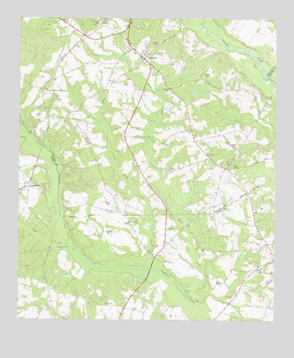
Oak Park, GA USGS Topographic Map
Click on map above to begin viewing in our Map Viewer.

This topographic map contains these locations and features:
Feature Name Type Latitude Longitude GNIS ID View Map
Collins CemeteryCemeteryN32.2880°W82.3021°312853View Map
Collins CemeteryCemeteryN32.3396°W82.2854°312854View Map
Corinth ChurchChurchN32.3285°W82.2912°312985View Map
Emanuel County Fire Department Station 06BuildingN32.3589°W82.3143°2604671View Map
Findley CemeteryCemeteryN32.3521°W82.2851°314126View Map
Harrell CemeteryCemeteryN32.3230°W82.3043°315173View Map
Holt AirparkAirportN32.3607°W82.3304°2442691View Map
Lane ChapelChurchN32.3185°W82.2832°316617View Map
Little Reedy CreekStreamN32.2716°W82.3096°317158View Map
Long BridgeBridgeN32.2710°W82.3104°345189View Map
Marietta ChurchChurchN32.2841°W82.2560°317696View Map
McLain CemeteryCemeteryN32.2705°W82.2587°317948View Map
Moore CemeteryCemeteryN32.2818°W82.2568°318433View Map
Morris CemeteryCemeteryN32.3635°W82.3476°318488View Map
Mosley CemeteryCemeteryN32.2868°W82.3321°318516View Map
Mosley CemeteryCemeteryN32.3127°W82.2985°318518View Map
Mount ChapelChurchN32.3138°W82.2704°318622View Map
Mount Zion ChurchChurchN32.2938°W82.2598°318973View Map
NormantownPopulated PlaceN32.3063°W82.3696°319627View Map
Normantown Volunteer Fire DepartmentBuildingN32.3067°W82.3706°2604945View Map
Oak ParkPopulated PlaceN32.3582°W82.3146°332536View Map
Oak Park CemeteryCemeteryN32.3638°W82.3082°319844View Map
Oak Park ChurchChurchN32.3457°W82.3026°319845View Map
Oak Park City Fire DepartmentBuildingN32.3589°W82.3143°2604067View Map
Oak Park DivisionCivilN32.3537°W82.3294°1936447View Map
Pendleton ChurchChurchN32.3243°W82.3721°320354View Map
Pendleton Springs CemeteryCemeteryN32.3446°W82.3596°347509View Map
Pendleton Springs ChurchChurchN32.3446°W82.3596°320357View Map
Piney Green ChurchChurchN32.2569°W82.3318°320694View Map
Reedy CreekStreamN32.2624°W82.2821°321450View Map
Sapp CemeteryCemeteryN32.2699°W82.2526°322515View Map
Thompson BridgeBridgeN32.3274°W82.3698°345217View Map
Tiger CreekStreamN32.2799°W82.3504°324170View Map
Town of Oak ParkCivilN32.3583°W82.3133°2407021View Map
Waters CemeteryCemeteryN32.3343°W82.3668°324904View Map
White ChapelChurchN32.2902°W82.3215°325148View Map
White Chapel CemeteryCemeteryN32.2913°W82.3176°325149View Map
Wilkes CemeteryCemeteryN32.2649°W82.2760°325302View Map
Williamson CemeteryCemeteryN32.2946°W82.3285°325376View Map

Note: Coordinates in the location and feature list above are referenced to NAD83 datum.


Copyright (C) 2008-2025 Ryan Niemi / Sunset Dynamics ... All Rights Reserved