TopoQuest Logo
Do you find TopoQuest useful?
Help keep TopoQuest running and adding new maps/features by donating!
Bitcoin:  19c7KJd3qBynnjoSw5npx9KScwjBe4ifkT
Litecoin:  LXs6TkuXGGXo1vDsWCkWVdjQX94eUKd6ui
Home View Maps Find Maps Find Places Resources & Links


Nunez, Georgia Topographic Map

USGS Map Title: Nunez, GA
USGS Map MRC: 32082D3
DRG (GeoTIFF) Download: o32082d3.tif


Neighboring USGS Topographic Map Quads:


  Norristown, GA  
32082E4
 

  Swainsboro, GA  
32082E3
 

  Twin City, GA  
32082E2
 

  Covena, GA  
32082D4
 

  Nunez, GA  
32082D3
 

  Stillmore, GA  
32082D2
 

  Oak Park SW, GA  
32082C4
 

  Oak Park, GA  
32082C3
 

  Cobbtown, GA  
32082C2


Map MRC Location:

N33°
W83°
N33°
W82°
H8 H7 H6 H5 H4 H3 H2 H1
G8 G7 G6 G5 G4 G3 G2 G1
F8 F7 F6 F5 F4 F3 F2 F1
E8 E7 E6 E5 E4 E3 E2 E1
D8 D7 D6 D5 D4 D3 D2 D1
C8 C7 C6 C5 C4 C3 C2 C1
B8 B7 B6 B5 B4 B3 B2 B1
A8 A7 A6 A5 A4 A3 A2 A1
N32°
W83°
N32°
W82°

Nunez, GA USGS 1:24K Topographic Map Preview:
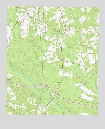
Nunez, GA USGS Topographic Map
Click on map above to begin viewing in our Map Viewer.

This topographic map contains these locations and features:
Feature Name Type Latitude Longitude GNIS ID View Map
City of NunezCivilN32.4920°W82.3467°2404405View Map
Edenfield - Slater CemeteryCemeteryN32.3963°W82.2612°323069View Map
Emanuel County Volunteer Fire Department Nunez StationBuildingN32.4937°W82.3445°2604073View Map
Exit 21CrossingN32.3993°W82.3082°1704995View Map
Flatford CemeteryCemeteryN32.4813°W82.3596°314205View Map
Gainer Corporation DamDamN32.3902°W82.3265°341403View Map
Gainer Corporation LakeReservoirN32.3878°W82.3275°341404View Map
Kirby CemeteryCemeteryN32.4071°W82.3040°316469View Map
LexsyPopulated PlaceN32.4685°W82.2973°316792View Map
Lexsy SchoolSchoolN32.4718°W82.3023°316793View Map
LombardPopulated PlaceN32.4257°W82.3251°326373View Map
New Hope ChurchChurchN32.4566°W82.3182°319394View Map
NunezPopulated PlaceN32.4913°W82.3471°319720View Map
Nunez Volunteer Fire DepartmentBuildingN32.4937°W82.3446°2603592View Map
Oak Park Lookout TowerTowerN32.3774°W82.3212°344311View Map
Open CreekStreamN32.4957°W82.3743°320077View Map
Phillips CemeteryCemeteryN32.3999°W82.3604°320454View Map
Phillips CemeteryCemeteryN32.4532°W82.2907°320456View Map
Reedy BranchStreamN32.4968°W82.3693°321442View Map
Rountree DamDamN32.4835°W82.2665°341401View Map
Rountree LakeReservoirN32.4862°W82.2651°341402View Map
Rowell CemeteryCemeteryN32.4154°W82.3740°321972View Map
WesleyPopulated PlaceN32.4835°W82.3310°325000View Map
Yam Grandy CreekStreamN32.4091°W82.3348°325596View Map
Yeomans CemeteryCemeteryN32.4682°W82.3307°325627View Map
Youmans CemeteryCemeteryN32.4863°W82.3518°325634View Map
Youmans CemeteryCemeteryN32.4982°W82.3243°325635View Map
Youmans LakeReservoirN32.4989°W82.3189°341400View Map
Youmans Lake DamDamN32.4968°W82.3182°341399View Map

Note: Coordinates in the location and feature list above are referenced to NAD83 datum.


Copyright (C) 2008-2025 Ryan Niemi / Sunset Dynamics ... All Rights Reserved