TopoQuest Logo
Do you find TopoQuest useful?
Help keep TopoQuest running and adding new maps/features by donating!
Bitcoin:  19c7KJd3qBynnjoSw5npx9KScwjBe4ifkT
Litecoin:  LXs6TkuXGGXo1vDsWCkWVdjQX94eUKd6ui
Home View Maps Find Maps Find Places Resources & Links


Cowan, Kentucky Topographic Map

USGS Map Title: Cowan, KY
USGS Map MRC: 38083D8
DRG (GeoTIFF) Download: o38083d8.tif


Neighboring USGS Topographic Map Quads:


  Mount Olivet, KY  
38084E1
 

  Sardis, KY  
38083E8
 

  Mays Lick, KY  
38083E7
 

  Piqua, KY  
38084D1
 

  Cowan, KY  
38083D8
 

  Elizaville, KY  
38083D7
 

  Carlisle, KY  
38084C1
 

  Moorefield, KY  
38083C8
 

  Sherburne, KY  
38083C7


Map MRC Location:

N39°
W84°
N39°
W83°
H8 H7 H6 H5 H4 H3 H2 H1
G8 G7 G6 G5 G4 G3 G2 G1
F8 F7 F6 F5 F4 F3 F2 F1
E8 E7 E6 E5 E4 E3 E2 E1
D8 D7 D6 D5 D4 D3 D2 D1
C8 C7 C6 C5 C4 C3 C2 C1
B8 B7 B6 B5 B4 B3 B2 B1
A8 A7 A6 A5 A4 A3 A2 A1
N38°
W84°
N38°
W83°

Cowan, KY USGS 1:24K Topographic Map Preview:
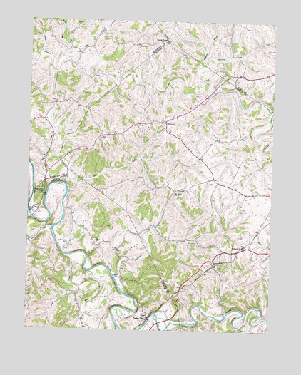
Cowan, KY USGS Topographic Map
Click on map above to begin viewing in our Map Viewer.

This topographic map contains these locations and features:
Feature Name Type Latitude Longitude GNIS ID View Map
Abner Post Office (historical)Post OfficeN38.4304°W83.9784°2555924View Map
Abners Mill (historical)LocaleN38.4325°W83.9772°2555926View Map
Absalom CreekStreamN38.4760°W83.9128°485738View Map
AlhambraPopulated PlaceN38.4904°W83.9455°507384View Map
Alhambra Post Office (historical)Post OfficeN38.4901°W83.9450°2556022View Map
Baker CreekStreamN38.4826°W83.9783°486247View Map
Big TunnelTunnelN38.3917°W83.9202°487285View Map
Blue Licks Battlefield State ParkParkN38.4284°W83.9946°487528View Map
Blue Licks SpringLocaleN38.4231°W83.9974°487529View Map
Buchanan CreekStreamN38.3956°W83.9544°488182View Map
Burika Post Office (historical)Post OfficeN38.4667°W83.9870°2555967View Map
Burika School (historical)SchoolN38.4668°W83.9868°2555982View Map
Cedar HillSummitN38.4273°W83.9932°2555923View Map
CowanPopulated PlaceN38.4073°W83.8919°490196View Map
Cowan Post Office (historical)Post OfficeN38.4070°W83.8921°2355184View Map
Cowan Railroad Station (historical)LocaleN38.4073°W83.8923°2355185View Map
Daton ChapelChurchN38.3804°W83.9380°490603View Map
Deer Lick School (historical)SchoolN38.4493°W83.9082°2355191View Map
Elk CreekStreamN38.4306°W83.9791°491654View Map
Evans MillsLocaleN38.4420°W83.8918°2355201View Map
FairviewPopulated PlaceN38.4595°W83.9308°491895View Map
Fairview School (historical)SchoolN38.4601°W83.9281°2355208View Map
Five Lick CreekStreamN38.4851°W83.9835°492152View Map
Flora Post Office (historical)Post OfficeN38.3850°W83.9722°2555884View Map
Furman ChapelChurchN38.4920°W83.9308°492625View Map
Goose CreekStreamN38.4009°W83.9708°493015View Map
Herndon CemeteryCemeteryN38.3965°W83.9521°494088View Map
Hildreth ChurchChurchN38.4106°W83.9635°494242View Map
Hildreth School (historical)SchoolN38.4018°W83.9677°2555888View Map
Hoovers RunStreamN38.3882°W83.8998°2355232View Map
Indian RunStreamN38.4420°W83.9988°494980View Map
Johnson BridgeBridgeN38.4731°W83.9051°2355235View Map
Johnson Creek Covered Bridge (historical)BridgeN38.4822°W83.9785°2556003View Map
Licking Post Office (historical)Post OfficeN38.4070°W83.9541°2555902View Map
Lower Blue LicksLocaleN38.4101°W83.9981°2555903View Map
Mint CreekStreamN38.3984°W83.9691°498425View Map
Mount Pisgah Baptist ChurchChurchN38.4558°W83.9442°2355253View Map
Mount Tabor Episcopal Methodist ChurchChurchN38.4312°W83.9246°498871View Map
Oakwood ChurchChurchN38.4859°W83.9173°2355261View Map
Oakwood Post Office (historical)Post OfficeN38.4595°W83.9304°2355262View Map
Pleasant Ridge ChurchChurchN38.4031°W83.9046°500898View Map
Pleasant ValleyPopulated PlaceN38.3792°W83.9380°508836View Map
Pleasant Valley Mills (historical)LocaleN38.3792°W83.9384°2555876View Map
Pleasant Valley Post Office (historical)Post OfficeN38.3793°W83.9378°2555882View Map
Pleasant Valley Railroad Station (historical)LocaleN38.3797°W83.9374°2555883View Map
Plugtown BranchStreamN38.4811°W83.9140°500960View Map
Rag BranchStreamN38.4876°W83.9946°501522View Map
Snow Hill School (historical)SchoolN38.4525°W83.9645°2355295View Map
Standiford CemeteryCemeteryN38.4101°W83.9794°504251View Map
Stony CreekStreamN38.4162°W83.9869°504500View Map
Straight CreekStreamN38.4895°W83.9805°504551View Map
Sunnyside CemeteryCemeteryN38.4315°W83.9235°504801View Map
Tabor BranchStreamN38.4165°W83.9347°2355304View Map
Tea RunStreamN38.3765°W83.8903°2355306View Map
The Bend of LickingBendN38.3994°W83.9693°2555368View Map
Tunnel HillSummitN38.3910°W83.9192°2355312View Map
Tunnel Hill School (historical)SchoolN38.3916°W83.9189°2355313View Map

Note: Coordinates in the location and feature list above are referenced to NAD83 datum.


Copyright (C) 2008-2025 Ryan Niemi / Sunset Dynamics ... All Rights Reserved