TopoQuest Logo
Do you find TopoQuest useful?
Help keep TopoQuest running and adding new maps/features by donating!
Bitcoin:  19c7KJd3qBynnjoSw5npx9KScwjBe4ifkT
Litecoin:  LXs6TkuXGGXo1vDsWCkWVdjQX94eUKd6ui
Home View Maps Find Maps Find Places Resources & Links


Piqua, Kentucky Topographic Map

USGS Map Title: Piqua, KY
USGS Map MRC: 38084D1
DRG (GeoTIFF) Download: o38084d1.tif


Neighboring USGS Topographic Map Quads:


  Claysville, KY  
38084E2
 

  Mount Olivet, KY  
38084E1
 

  Sardis, KY  
38083E8
 

  Shady Nook, KY  
38084D2
 

  Piqua, KY  
38084D1
 

  Cowan, KY  
38083D8
 

  Millersburg, KY  
38084C2
 

  Carlisle, KY  
38084C1
 

  Moorefield, KY  
38083C8


Map MRC Location:

N39°
W85°
N39°
W84°
H8 H7 H6 H5 H4 H3 H2 H1
G8 G7 G6 G5 G4 G3 G2 G1
F8 F7 F6 F5 F4 F3 F2 F1
E8 E7 E6 E5 E4 E3 E2 E1
D8 D7 D6 D5 D4 D3 D2 D1
C8 C7 C6 C5 C4 C3 C2 C1
B8 B7 B6 B5 B4 B3 B2 B1
A8 A7 A6 A5 A4 A3 A2 A1
N38°
W85°
N38°
W84°

Piqua, KY USGS 1:24K Topographic Map Preview:
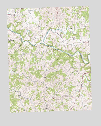
Piqua, KY USGS Topographic Map
Click on map above to begin viewing in our Map Viewer.

This topographic map contains these locations and features:
Feature Name Type Latitude Longitude GNIS ID View Map
Adkins Brothers LakeReservoirN38.4939°W84.1229°2556045View Map
Ball Hill ChurchChurchN38.3956°W84.0566°486289View Map
BarefootPopulated PlaceN38.4237°W84.1169°507452View Map
Barefoot Post Office (historical)Post OfficeN38.4237°W84.1169°2555911View Map
Barefoot School (historical)SchoolN38.4247°W84.1187°2555922View Map
BartervillePopulated PlaceN38.3790°W84.0688°486445View Map
Barterville Post Office (historical)Post OfficeN38.3783°W84.0696°2555873View Map
Barterville School (historical)SchoolN38.3786°W84.0692°2555874View Map
Bee LickStreamN38.4737°W84.0344°486673View Map
Bethlehem CemeteryCemeteryN38.4423°W84.1077°487010View Map
Cedar CreekStreamN38.4765°W84.1224°489182View Map
Chapel Post Office (historical)Post OfficeN38.4477°W84.0838°2555931View Map
Cow HollowValleyN38.4973°W84.0206°490193View Map
Crayton Post Office (historical)Post OfficeN38.4445°W84.0733°2555928View Map
Crayton School (historical)SchoolN38.4439°W84.0730°2555927View Map
Crooked CreekStreamN38.4601°W84.0991°490377View Map
Days Ferry (historical)CrossingN38.4516°W84.0548°2555950View Map
Days Mill (historical)LocaleN38.4494°W84.0668°2555945View Map
East Branch Painter CreekStreamN38.4367°W84.0769°491427View Map
East Branch Sugar CreekStreamN38.4406°W84.0277°491429View Map
Elk LickStreamN38.4690°W84.1247°491664View Map
Ellis Tavern (historical)LocaleN38.4045°W84.0130°2555362View Map
EllisvillePopulated PlaceN38.3909°W84.0208°507930View Map
Ellisville Post Office (historical)Post OfficeN38.3909°W84.0210°2555885View Map
Headquarters DivisionCivilN38.3876°W84.0573°1937053View Map
HogjawsLocaleN38.4172°W84.0926°2555907View Map
Jim Berry Iron BridgeBridgeN38.4761°W84.0070°2556002View Map
Johnson CreekStreamN38.4576°W84.0722°495400View Map
Kendall School (historical)SchoolN38.4163°W84.0999°2555906View Map
KentontownPopulated PlaceN38.4929°W84.1194°495664View Map
Kentontown CemeteryCemeteryN38.4943°W84.1190°2556046View Map
Kentontown Post Office (historical)Post OfficeN38.4932°W84.1205°2556044View Map
Kentontown School (historical)SchoolN38.4925°W84.1180°2556043View Map
Martins LakeReservoirN38.4603°W84.0305°2555957View Map
Masonic Lodge HallLocaleN38.4203°W84.0090°2555909View Map
Mitchells Mill (historical)LocaleN38.4746°W84.0020°2555984View Map
Mount Pleasant (historical)Populated PlaceN38.4920°W84.0179°2556042View Map
Mount Pleasant ChurchChurchN38.4917°W84.0174°498854View Map
Needmore ChurchChurchN38.4481°W84.0824°499223View Map
Needmore Church CemeteryCemeteryN38.4482°W84.0829°2555943View Map
North Branch Cedar CreekStreamN38.4909°W84.1074°499535View Map
Painter CreekStreamN38.4517°W84.0563°500123View Map
Paynter Post Office (historical)Post OfficeN38.4515°W84.0557°2555947View Map
PiquaPopulated PlaceN38.4662°W84.0452°508828View Map
Piqua BridgeBridgeN38.4729°W84.0487°2555983View Map
Piqua Church CemeteryCemeteryN38.4604°W84.0418°2555960View Map
Piqua Post Office (historical)Post OfficeN38.4667°W84.0463°2555965View Map
Plank RunStreamN38.4470°W84.0438°500792View Map
Plummers Landing (historical)LocaleN38.4519°W84.0562°2555954View Map
Poke Wagoner HillSummitN38.4309°W84.1225°2555925View Map
Punkin Center (historical)LocaleN38.4614°W84.0225°2555962View Map
Rafferty School (historical)SchoolN38.4208°W84.0096°2555910View Map
Rose HillSummitN38.4199°W84.0632°2555908View Map
Rose Hill ChurchChurchN38.4156°W84.0722°502339View Map
Rose Hill Church CemeteryCemeteryN38.4160°W84.0722°2555905View Map
Rose Hill School (historical)SchoolN38.4139°W84.0701°2555904View Map
Salt WellLocaleN38.3954°W84.1080°502837View Map
Salt Well CemeteryCemeteryN38.3953°W84.1083°502840View Map
Salt Well Post Office (historical)Post OfficeN38.3951°W84.1091°2555886View Map
Small School (historical)SchoolN38.4462°W84.1021°2555929View Map
The Old Wash Place (historical)LocaleN38.4468°W84.0440°2555930View Map
Thomas SchoolSchoolN38.4779°W84.0783°505175View Map
Turkey RunStreamN38.4604°W84.0710°505630View Map
Wagoners ChapelChurchN38.4615°W84.1219°506103View Map
West Branch Painter CreekStreamN38.4365°W84.0769°506406View Map
West Branch Sugar CreekStreamN38.4406°W84.0277°506407View Map

Note: Coordinates in the location and feature list above are referenced to NAD83 datum.


Copyright (C) 2008-2024 Ryan Niemi / Sunset Dynamics ... All Rights Reserved