TopoQuest Logo
Do you find TopoQuest useful?
Help keep TopoQuest running and adding new maps/features by donating!
Bitcoin:  19c7KJd3qBynnjoSw5npx9KScwjBe4ifkT
Litecoin:  LXs6TkuXGGXo1vDsWCkWVdjQX94eUKd6ui
Home View Maps Find Maps Find Places Resources & Links


Cowen, West Virginia Topographic Map

USGS Map Title: Cowen, WV
USGS Map MRC: 38080D5
DRG (GeoTIFF) Download: o38080d5.tif


Neighboring USGS Topographic Map Quads:


  Little Birch, WV  
38080E6
 

  Erbacon, WV  
38080E5
 

  Diana, WV  
38080E4
 

  Tioga, WV  
38080D6
 

  Cowen, WV  
38080D5
 

  Webster Springs, WV  
38080D4
 

  Craigsville, WV  
38080C6
 

  Camden On Gauley, WV  
38080C5
 

  Webster Springs SW, WV  
38080C4


Map MRC Location:

N39°
W81°
N39°
W80°
H8 H7 H6 H5 H4 H3 H2 H1
G8 G7 G6 G5 G4 G3 G2 G1
F8 F7 F6 F5 F4 F3 F2 F1
E8 E7 E6 E5 E4 E3 E2 E1
D8 D7 D6 D5 D4 D3 D2 D1
C8 C7 C6 C5 C4 C3 C2 C1
B8 B7 B6 B5 B4 B3 B2 B1
A8 A7 A6 A5 A4 A3 A2 A1
N38°
W81°
N38°
W80°

Cowen, WV USGS 1:24K Topographic Map Preview:
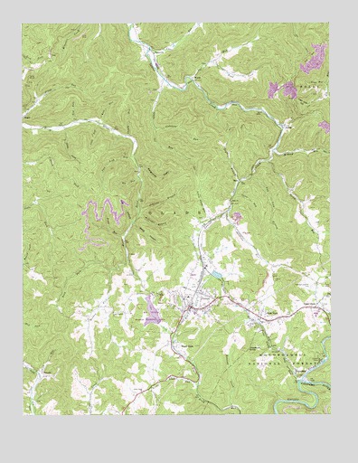
Cowen, WV USGS Topographic Map
Click on map above to begin viewing in our Map Viewer.

This topographic map contains these locations and features:
Feature Name Type Latitude Longitude GNIS ID View Map
Adkinson CemeteryCemeteryN38.4381°W80.5520°2728241View Map
Amos RunStreamN38.4918°W80.5729°1550103View Map
ArcolaPopulated PlaceN38.4668°W80.5193°1550113View Map
Back ForkStreamN38.4215°W80.5884°1550136View Map
Baughman DraftValleyN38.4540°W80.5770°1550178View Map
Bee RunStreamN38.4512°W80.5776°1550239View Map
Big Ditch Run Structure One DamDamN38.4084°W80.5731°1559329View Map
Big Ditch Wildlife Management AreaParkN38.4065°W80.5720°1553614View Map
Boggs Post OfficePost OfficeN38.4684°W80.6245°1727832View Map
Bragg Run CemeteryCemeteryN38.4763°W80.6184°2728611View Map
Chestnut KnobSummitN38.3962°W80.5345°1550694View Map
Chuffy RunStreamN38.4634°W80.5831°1550713View Map
Coal HollowValleyN38.4371°W80.5804°1550737View Map
Cobb RunStreamN38.4682°W80.5934°1550749View Map
Cookman School (historical)SchoolN38.4251°W80.5487°1727842View Map
CowenPopulated PlaceN38.4096°W80.5579°1554208View Map
Cowen Police DepartmentBuildingN38.4116°W80.5586°2727674View Map
Cowen Post OfficePost OfficeN38.4106°W80.5574°1727844View Map
Cowen Public LibraryBuildingN38.4081°W80.5558°2727390View Map
Cowen Volunteer Fire DepartmentBuildingN38.4091°W80.5577°2578057View Map
Deep HollowValleyN38.4359°W80.5793°1550894View Map
Dennison RunStreamN38.4404°W80.5406°1550905View Map
DonaldsonPopulated PlaceN38.3873°W80.5118°1550942View Map
Dry BranchStreamN38.4496°W80.5365°1550957View Map
Given RunStreamN38.4565°W80.5251°1551232View Map
Glade Elementary SchoolSchoolN38.4077°W80.5552°1727858View Map
Glade RunStreamN38.4818°W80.5673°1551236View Map
Glade Run Cemetery CemeteryN38.4754°W80.5712°2728975View Map
Glade Summit ChurchChurchN38.4079°W80.5881°1551242View Map
Glade ViewPopulated PlaceN38.4062°W80.5287°1554560View Map
HaloPopulated PlaceN38.4501°W80.5368°1554629View Map
Halo ChurchChurchN38.4432°W80.5401°1551331View Map
Handschumacher CemeteryCemeteryN38.4159°W80.5081°1551349View Map
High Coal HollowValleyN38.4765°W80.5023°1551425View Map
Holcomb CreekStreamN38.3776°W80.5398°1551472View Map
Hollister School (historical)SchoolN38.3987°W80.5245°1727865View Map
Hoover CemeteryCemeteryN38.4145°W80.5758°2586171View Map
Jacks RunStreamN38.4326°W80.5837°1551555View Map
Johnson BranchStreamN38.4404°W80.5773°1551593View Map
Kate RunStreamN38.4684°W80.5940°1551623View Map
Lick RunStreamN38.3882°W80.6187°1551791View Map
Little Glade ChurchChurchN38.3826°W80.5762°1551856View Map
Little Glade RunStreamN38.3840°W80.5545°1551857View Map
Little Glade RunStreamN38.4373°W80.5484°1551858View Map
Little Glade School (historical)SchoolN38.3829°W80.5759°1727872View Map
Locust Grove School (historical)SchoolN38.4098°W80.5901°1727873View Map
Long Glade DitchCanalN38.4043°W80.5698°1551918View Map
Lost RunStreamN38.4826°W80.5570°1551948View Map
Lost Run School (historical)SchoolN38.4871°W80.5459°1727874View Map
McAvoy RunStreamN38.4587°W80.5229°1552021View Map
McElwain CemeteryCemeteryN38.4897°W80.5465°2586342View Map
Meadow ForkStreamN38.4215°W80.5887°1552049View Map
Mount Thomas School (historical)SchoolN38.4854°W80.6206°1727885View Map
Norman School (historical)SchoolN38.4554°W80.6218°1727888View Map
Oddfellows Cemetery CemeteryN38.4110°W80.5465°2729038View Map
Otter HoleValleyN38.4662°W80.6076°1552400View Map
Pine Grove School (historical)SchoolN38.4240°W80.5815°1727895View Map
Price Glade RunStreamN38.3859°W80.5131°1552559View Map
Reynolds School (historical)SchoolN38.4387°W80.5423°1727906View Map
Road ForkStreamN38.4868°W80.5498°1552678View Map
Silk RunStreamN38.4684°W80.6029°1552891View Map
Slabcamp RunStreamN38.4671°W80.5715°1552914View Map
Southern DistrictCivilN38.4153°W80.5923°1928365View Map
Spice RunStreamN38.4454°W80.5387°1552996View Map
StalnakerCemeteryN38.4934°W80.5651°2728254View Map
StroudsPopulated PlaceN38.3879°W80.6165°1553100View Map
Town of CowenCivilN38.4110°W80.5542°2390814View Map
Trap RunStreamN38.4807°W80.5009°1553255View Map
Two Lick BranchStreamN38.4515°W80.5312°1553300View Map
Two Lick RunStreamN38.4573°W80.5798°1553302View Map
UppergladePopulated PlaceN38.4093°W80.5068°1553322View Map
Upperglade Post OfficePost OfficeN38.4110°W80.5049°1727923View Map
WainvillePopulated PlaceN38.4915°W80.5729°1553354View Map
Watson School (historical)SchoolN38.4359°W80.5081°1727927View Map
Webster County High SchoolSchoolN38.4071°W80.5059°1727929View Map
WeesePopulated PlaceN38.4821°W80.5559°1553399View Map
Welch GladePopulated PlaceN38.3973°W80.5640°1553401View Map
West Virginia State Police Troop 3 - Webster Springs DetachmentBuildingN38.4087°W80.5074°2727673View Map
Williams BranchStreamN38.4390°W80.5779°1553459View Map
Williams RiverStreamN38.3851°W80.5134°1553463View Map

Note: Coordinates in the location and feature list above are referenced to NAD83 datum.


Copyright (C) 2008-2025 Ryan Niemi / Sunset Dynamics ... All Rights Reserved