TopoQuest Logo
Do you find TopoQuest useful?
Help keep TopoQuest running and adding new maps/features by donating!
Bitcoin:  19c7KJd3qBynnjoSw5npx9KScwjBe4ifkT
Litecoin:  LXs6TkuXGGXo1vDsWCkWVdjQX94eUKd6ui
Home View Maps Find Maps Find Places Resources & Links


Tioga, West Virginia Topographic Map

USGS Map Title: Tioga, WV
USGS Map MRC: 38080D6
DRG (GeoTIFF) Download: o38080d6.tif


Neighboring USGS Topographic Map Quads:


  Herold, WV  
38080E7
 

  Little Birch, WV  
38080E6
 

  Erbacon, WV  
38080E5
 

  Widen, WV  
38080D7
 

  Tioga, WV  
38080D6
 

  Cowen, WV  
38080D5
 

  Summersville, WV  
38080C7
 

  Craigsville, WV  
38080C6
 

  Camden On Gauley, WV  
38080C5


Map MRC Location:

N39°
W81°
N39°
W80°
H8 H7 H6 H5 H4 H3 H2 H1
G8 G7 G6 G5 G4 G3 G2 G1
F8 F7 F6 F5 F4 F3 F2 F1
E8 E7 E6 E5 E4 E3 E2 E1
D8 D7 D6 D5 D4 D3 D2 D1
C8 C7 C6 C5 C4 C3 C2 C1
B8 B7 B6 B5 B4 B3 B2 B1
A8 A7 A6 A5 A4 A3 A2 A1
N38°
W81°
N38°
W80°

Tioga, WV USGS 1:24K Topographic Map Preview:
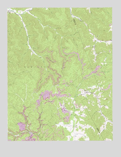
Tioga, WV USGS Topographic Map
Click on map above to begin viewing in our Map Viewer.

This topographic map contains these locations and features:
Feature Name Type Latitude Longitude GNIS ID View Map
Amos CemeteryCemeteryN38.4634°W80.6474°2728247View Map
Anthony CreekStreamN38.4937°W80.7348°1534969View Map
Anthony Creek School (historical)SchoolN38.4740°W80.7259°1741047View Map
Armstrong CemeteryCemeteryN38.4958°W80.7493°2586392View Map
Barnet RunStreamN38.4693°W80.6415°1535263View Map
Barnet Run School (historical)SchoolN38.4637°W80.6470°1727821View Map
Barnett Family CemeteryCemeteryN38.4897°W80.6633°2586310View Map
Bearpen ForkStreamN38.4001°W80.6729°1535417View Map
Big RunStreamN38.4051°W80.6690°1535902View Map
Bills BranchStreamN38.4759°W80.6898°1536001View Map
Birch River Census Designated PlaceCensusN38.4961°W80.7497°2586766View Map
Birch River Elementary SchoolSchoolN38.4973°W80.7484°1741054View Map
Board ForkStreamN38.4246°W80.6656°1550407View Map
BoggsPopulated PlaceN38.4687°W80.6251°1550412View Map
Boggs CemeteryCemeteryN38.4690°W80.6440°1536192View Map
Bragg RunStreamN38.4676°W80.6254°1550441View Map
Buck BranchStreamN38.4554°W80.7012°1536549View Map
Cabin RunStreamN38.4593°W80.7198°1536831View Map
Cat RunStreamN38.4562°W80.6448°1537102View Map
Clear ForkStreamN38.3829°W80.7240°1537389View Map
Cobb RunStreamN38.4659°W80.7243°1537484View Map
Crooked RunStreamN38.3915°W80.7282°1537846View Map
DelphiPopulated PlaceN38.3882°W80.6701°1554286View Map
Delphi United Methodist ChurchChurchN38.3890°W80.6718°1741071View Map
Dryhouse RunStreamN38.4620°W80.7218°1538392View Map
Falls RunStreamN38.4009°W80.7318°1538881View Map
Gauley Eagle Number Four ImpoundmentReservoirN38.3784°W80.7315°1559185View Map
Gauley Eagle Slurry ImpoundmentReservoirN38.3751°W80.7215°1559189View Map
Gauley Eagle Slurry Pond DamDamN38.3751°W80.7215°1559188View Map
Golden BranchStreamN38.4737°W80.6734°1539492View Map
Harris ForkStreamN38.3809°W80.7140°1551373View Map
Hog Rock BranchStreamN38.4740°W80.6715°1540352View Map
Horse RunStreamN38.3890°W80.6709°1540493View Map
Jane BranchStreamN38.4826°W80.7070°1540817View Map
Josh HollowValleyN38.4723°W80.6829°1541029View Map
Kettle RunStreamN38.4826°W80.7298°1541173View Map
Laurel ForkStreamN38.3823°W80.7223°1551713View Map
Laurel Lick RunStreamN38.4023°W80.6390°1541484View Map
Left Fork Big Beaver CreekStreamN38.3829°W80.6748°1541630View Map
Left Fork Poplar CreekStreamN38.4729°W80.6848°1541703View Map
Lick ForkStreamN38.3834°W80.6731°1551788View Map
Lick ForkStreamN38.4998°W80.6529°1551789View Map
Lower Cabin RunStreamN38.4623°W80.7220°1542530View Map
Lower Laurel RunStreamN38.4151°W80.6698°1542549View Map
Lowry BranchStreamN38.3890°W80.7104°1542598View Map
Maston RunStreamN38.4818°W80.7290°1542859View Map
Ming RunStreamN38.4704°W80.6434°1543438View Map
Mud ForkStreamN38.4068°W80.6384°1552251View Map
Mudlick RunStreamN38.4732°W80.7259°1543954View Map
Norton BranchStreamN38.3934°W80.7109°1544240View Map
O'Brien ForkStreamN38.4407°W80.6395°1552352View Map
Oldhe ForkStreamN38.4407°W80.6395°1552385View Map
Paddy RunStreamN38.3971°W80.6731°1544516View Map
Panther Lick BranchStreamN38.4543°W80.6795°1544556View Map
Poplar CreekStreamN38.4970°W80.7243°1545140View Map
Poplar Creek School (historical)SchoolN38.4887°W80.7126°1741107View Map
Rader ChapelChurchN38.4634°W80.6465°1545373View Map
Red Oak BranchStreamN38.4623°W80.6862°1545457View Map
Rich ForkStreamN38.4534°W80.7098°1545546View Map
Rich ForkStreamN38.4926°W80.6715°1545547View Map
Road ForkStreamN38.4409°W80.7034°1545810View Map
Rockhouse RunStreamN38.4409°W80.7034°1545986View Map
Simmons BranchStreamN38.4801°W80.6932°1546792View Map
Slide BranchStreamN38.3776°W80.7104°1546942View Map
Sugarcamp RunStreamN38.3804°W80.7401°1553132View Map
Sugarcamp RunStreamN38.3934°W80.6304°1553133View Map
TiogaPopulated PlaceN38.4204°W80.6562°1548104View Map
Tioga Census Designated PlaceCensusN38.4220°W80.6549°2586889View Map
Tioga Post OfficePost OfficeN38.4204°W80.6580°1741121View Map
Tioga United Methodist ChurchChurchN38.4204°W80.6581°1741122View Map
Upper Laurel RunStreamN38.4240°W80.6665°1548530View Map
Walnut ForkStreamN38.4182°W80.6673°1548749View Map
Walnut Grove ChapelChurchN38.4684°W80.6331°1548759View Map

Note: Coordinates in the location and feature list above are referenced to NAD83 datum.


Copyright (C) 2008-2025 Ryan Niemi / Sunset Dynamics ... All Rights Reserved