TopoQuest Logo
Do you find TopoQuest useful?
Help keep TopoQuest running and adding new maps/features by donating!
Bitcoin:  19c7KJd3qBynnjoSw5npx9KScwjBe4ifkT
Litecoin:  LXs6TkuXGGXo1vDsWCkWVdjQX94eUKd6ui
Home View Maps Find Maps Find Places Resources & Links


Erbacon, West Virginia Topographic Map

USGS Map Title: Erbacon, WV
USGS Map MRC: 38080E5
DRG (GeoTIFF) Download: o38080e5.tif


Neighboring USGS Topographic Map Quads:


  Sutton, WV  
38080F6
 

  Newville, WV  
38080F5
 

  Hacker Valley, WV  
38080F4
 

  Little Birch, WV  
38080E6
 

  Erbacon, WV  
38080E5
 

  Diana, WV  
38080E4
 

  Tioga, WV  
38080D6
 

  Cowen, WV  
38080D5
 

  Webster Springs, WV  
38080D4


Map MRC Location:

N39°
W81°
N39°
W80°
H8 H7 H6 H5 H4 H3 H2 H1
G8 G7 G6 G5 G4 G3 G2 G1
F8 F7 F6 F5 F4 F3 F2 F1
E8 E7 E6 E5 E4 E3 E2 E1
D8 D7 D6 D5 D4 D3 D2 D1
C8 C7 C6 C5 C4 C3 C2 C1
B8 B7 B6 B5 B4 B3 B2 B1
A8 A7 A6 A5 A4 A3 A2 A1
N38°
W81°
N38°
W80°

Erbacon, WV USGS 1:24K Topographic Map Preview:
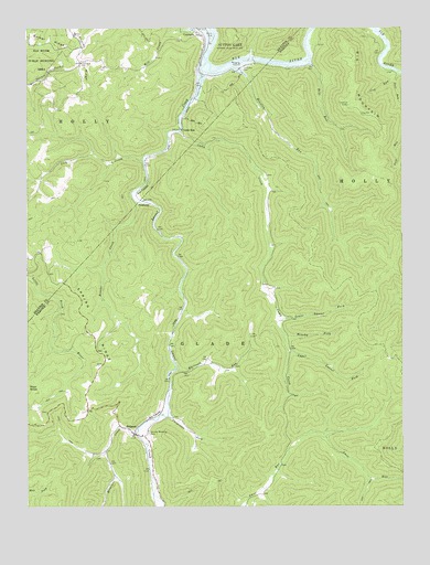
Erbacon, WV USGS Topographic Map
Click on map above to begin viewing in our Map Viewer.

This topographic map contains these locations and features:
Feature Name Type Latitude Longitude GNIS ID View Map
Bear RunStreamN38.6162°W80.5306°1535383View Map
Big MountainSummitN38.6023°W80.5109°1553899View Map
Big Mountain Lookout TowerLocaleN38.6048°W80.5179°1727827View Map
Brooks CreekStreamN38.5795°W80.5884°1536390View Map
Brushy ForkStreamN38.5454°W80.5398°1536498View Map
Camp CreekStreamN38.5984°W80.5737°1536914View Map
Camp RunLocaleN38.5970°W80.5731°1536938View Map
Carpenter ForkStreamN38.5245°W80.5781°1537053View Map
CentraliaPopulated PlaceN38.6232°W80.5679°1554101View Map
Centralia CemeteryCemeteryN38.6143°W80.5534°1537175View Map
Centralia Post OfficePost OfficeN38.6232°W80.5670°1727314View Map
Cleveland School (historical)SchoolN38.6159°W80.6070°1537402View Map
Cow RunStreamN38.6143°W80.5031°1537743View Map
Defoe (historical)Populated PlaceN38.5473°W80.5762°1727846View Map
ErbaconPopulated PlaceN38.5190°W80.5890°1538734View Map
Erbacon Post OfficePost OfficeN38.5195°W80.5893°1727855View Map
Erbacon Volunteer Fire DepartmentBuildingN38.5187°W80.5864°2577922View Map
Gulf RunStreamN38.6132°W80.5006°1539785View Map
Houston RunStreamN38.6159°W80.5573°1540524View Map
Laurel CreekStreamN38.6159°W80.5656°1551707View Map
Lick CreekStreamN38.5904°W80.5862°1541884View Map
Lower Laurel ForkStreamN38.5495°W80.5409°1542548View Map
McCourt-Cogar CemeteryCemeteryN38.5863°W80.5452°2586341View Map
Missouri CreekStreamN38.5187°W80.5887°1552165View Map
Poplar RidgeRidgeN38.6182°W80.6076°1545150View Map
PrestoniaLocaleN38.5790°W80.5840°1549882View Map
Spring RidgeRidgeN38.5451°W80.6043°1547204View Map
Sunset Memorial ParkCemeteryN38.5193°W80.5845°1547767View Map
Upper Laurel ForkStreamN38.5409°W80.5370°1548529View Map
Whiteoak RunStreamN38.5357°W80.5756°1549089View Map

Note: Coordinates in the location and feature list above are referenced to NAD83 datum.


Copyright (C) 2008-2025 Ryan Niemi / Sunset Dynamics ... All Rights Reserved