TopoQuest Logo
Do you find TopoQuest useful?
Help keep TopoQuest running and adding new maps/features by donating!
Bitcoin:  19c7KJd3qBynnjoSw5npx9KScwjBe4ifkT
Litecoin:  LXs6TkuXGGXo1vDsWCkWVdjQX94eUKd6ui
Home View Maps Find Maps Find Places Resources & Links


Crawford, Georgia Topographic Map

USGS Map Title: Crawford, GA
USGS Map MRC: 33083H2
DRG (GeoTIFF) Download: o33083h2.tif


Neighboring USGS Topographic Map Quads:


  Hull, GA  
34083A3
 

  Danielsville South, GA  
34083A2
 

  Carlton, GA  
34083A1
 

  Athens East, GA  
33083H3
 

  Crawford, GA  
33083H2
 

  Sandy Cross, GA  
33083H1
 

  Barnett Shoals, GA  
33083G3
 

  Maxeys, GA  
33083G2
 

  Lexington, GA  
33083G1


Map MRC Location:

N34°
W84°
N34°
W83°
H8 H7 H6 H5 H4 H3 H2 H1
G8 G7 G6 G5 G4 G3 G2 G1
F8 F7 F6 F5 F4 F3 F2 F1
E8 E7 E6 E5 E4 E3 E2 E1
D8 D7 D6 D5 D4 D3 D2 D1
C8 C7 C6 C5 C4 C3 C2 C1
B8 B7 B6 B5 B4 B3 B2 B1
A8 A7 A6 A5 A4 A3 A2 A1
N33°
W84°
N33°
W83°

Crawford, GA USGS 1:24K Topographic Map Preview:
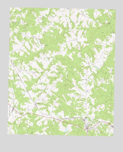
Crawford, GA USGS Topographic Map
Click on map above to begin viewing in our Map Viewer.

This topographic map contains these locations and features:
Feature Name Type Latitude Longitude GNIS ID View Map
ArnoldsvillePopulated PlaceN33.9051°W83.2168°354397View Map
Arnoldsville Baptist ChurchChurchN33.9079°W83.2168°335723View Map
Arnoldsville Volunteer Fire DepartmentBuildingN33.9018°W83.2185°2604614View Map
Beaver Dam LakeReservoirN33.9972°W83.2024°336478View Map
Beaver Dam Lake DamDamN33.9968°W83.2032°336477View Map
Beaverdam CemeteryCemeteryN33.9828°W83.2311°310993View Map
Beaverdam Primitive Baptist ChurchChurchN33.9798°W83.2302°354512View Map
Beaverdam Volunteer Fire DepartmentBuildingN33.9805°W83.2301°2604817View Map
Big LakeReservoirN33.9889°W83.1766°336476View Map
Big Lake DamDamN33.9868°W83.1732°336475View Map
Brooks LakeReservoirN33.8873°W83.1372°336474View Map
Brooks Lake DamDamN33.8868°W83.1365°336473View Map
Cherokee Corners ChurchChurchN33.8946°W83.2335°355135View Map
City of ArnoldsvilleCivilN33.9103°W83.2181°2403115View Map
City of CrawfordCivilN33.8830°W83.1552°2404145View Map
Clouds Creek CemeteryCemeteryN33.9774°W83.1258°312761View Map
Coile Grove CemeteryCemeteryN33.9697°W83.1704°312805View Map
Coiles Grove Baptist Church (historical)ChurchN33.9696°W83.1699°335737View Map
CrawfordPopulated PlaceN33.8829°W83.1546°355367View Map
Crawford Baptist ChurchChurchN33.8835°W83.1557°335739View Map
Crawford CemeteryCemeteryN33.8812°W83.1515°335740View Map
Crawford DivisionCivilN33.9225°W83.1420°1936359View Map
Crawford Methodist ChurchChurchN33.8837°W83.1557°335741View Map
Crawford Volunteer Fire DepartmentBuildingN33.8787°W83.1559°2603629View Map
Dam Number 65ReservoirN33.9201°W83.1899°338565View Map
Dawson CemeteryCemeteryN33.9479°W83.2474°335744View Map
Devil's Pond Volunteer Fire DepartmentBuildingN33.9200°W83.1559°2604837View Map
Devils PondReservoirN33.9177°W83.1584°335746View Map
Edwards ChurchChurchN33.8918°W83.1571°355646View Map
Grove Chapel ChurchChurchN33.9362°W83.2204°314935View Map
Hawks CreekStreamN33.9818°W83.1385°315250View Map
Howards Covered BridgeBridgeN33.9859°W83.1335°335757View Map
Jefferson MillLocaleN33.8912°W83.1610°335759View Map
Lake GeorgeReservoirN33.8802°W83.1805°336472View Map
Lake George DamDamN33.8785°W83.1815°336471View Map
Martin CemeteryCemeteryN33.9922°W83.1314°335767View Map
Mathews CemeteryCemeteryN33.9899°W83.2131°317784View Map
Mill CreekStreamN33.9484°W83.1704°318207View Map
New Zion ChurchChurchN33.8923°W83.1718°319561View Map
Oglethorpe County High SchoolSchoolN33.8840°W83.1250°335782View Map
Oglethorpe County Middle SchoolSchoolN33.8847°W83.1257°335783View Map
Popes Station (historical)LocaleN33.8918°W83.1946°335789View Map
Randolph Tucker CemeteryCemeteryN33.9868°W83.1368°335792View Map
Rocky CreekStreamN33.9373°W83.1793°321808View Map
Saint James ChurchChurchN33.8960°W83.2254°322093View Map
Shepherds BranchStreamN33.9909°W83.1360°335795View Map
Sonlight ChurchChurchN33.9718°W83.2221°323219View Map
South Fork Broad River Number 65 DamDamN33.9201°W83.1899°338564View Map
Sulphur Spring BranchStreamN33.9973°W83.2254°310359View Map
Union Presbyterian Church (historical)ChurchN33.8951°W83.2338°335799View Map
Wallis School for Girls (historical)SchoolN33.8951°W83.2332°335801View Map
Welcome Avenue ChurchChurchN33.9304°W83.1571°324973View Map
WGMG-FM (Crawford)TowerN33.9218°W83.2371°352669View Map
WUGA-FM (Athens)TowerN33.9204°W83.2460°352614View Map

Note: Coordinates in the location and feature list above are referenced to NAD83 datum.


Copyright (C) 2008-2025 Ryan Niemi / Sunset Dynamics ... All Rights Reserved