TopoQuest Logo
Do you find TopoQuest useful?
Help keep TopoQuest running and adding new maps/features by donating!
Bitcoin:  19c7KJd3qBynnjoSw5npx9KScwjBe4ifkT
Litecoin:  LXs6TkuXGGXo1vDsWCkWVdjQX94eUKd6ui
Home View Maps Find Maps Find Places Resources & Links


Lexington, Georgia Topographic Map

USGS Map Title: Lexington, GA
USGS Map MRC: 33083G1
DRG (GeoTIFF) Download: o33083g1.tif


Neighboring USGS Topographic Map Quads:


  Crawford, GA  
33083H2
 

  Sandy Cross, GA  
33083H1
 

  Vesta, GA  
33082H8
 

  Maxeys, GA  
33083G2
 

  Lexington, GA  
33083G1
 

  Rayle, GA  
33082G8
 

  Penfield, GA  
33083F2
 

  Woodville, GA  
33083F1
 

  Philomath, GA  
33082F8


Map MRC Location:

N34°
W84°
N34°
W83°
H8 H7 H6 H5 H4 H3 H2 H1
G8 G7 G6 G5 G4 G3 G2 G1
F8 F7 F6 F5 F4 F3 F2 F1
E8 E7 E6 E5 E4 E3 E2 E1
D8 D7 D6 D5 D4 D3 D2 D1
C8 C7 C6 C5 C4 C3 C2 C1
B8 B7 B6 B5 B4 B3 B2 B1
A8 A7 A6 A5 A4 A3 A2 A1
N33°
W84°
N33°
W83°

Lexington, GA USGS 1:24K Topographic Map Preview:
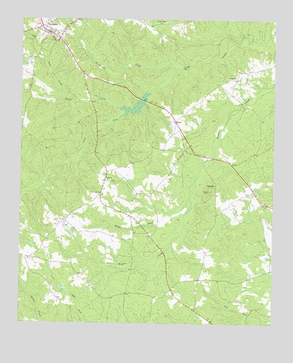
Lexington, GA USGS Topographic Map
Click on map above to begin viewing in our Map Viewer.

This topographic map contains these locations and features:
Feature Name Type Latitude Longitude GNIS ID View Map
Atkins CemeteryCemeteryN33.8082°W83.0807°335725View Map
Big MountainSummitN33.8046°W83.0318°331163View Map
Bobby Maxwell Airstrip (historical)AirportN33.8071°W83.0632°351822View Map
Brooks CreekStreamN33.8385°W83.0760°327226View Map
City of LexingtonCivilN33.8701°W83.1102°2404921View Map
Clark Grove ChurchChurchN33.8037°W83.0852°355172View Map
Guarentee MineMineN33.8051°W83.0082°335753View Map
HoganPopulated PlaceN33.8332°W83.0485°326330View Map
LexingtonPopulated PlaceN33.8698°W83.1118°316791View Map
Lexington CemeteryCemeteryN33.8704°W83.1088°335762View Map
Lexington Historic DistrictParkN33.8696°W83.1118°335763View Map
Lexington Presbyterian ChurchChurchN33.8701°W83.1088°335764View Map
Lexington Volunteer Fire DepartmentBuildingN33.8695°W83.1104°2604624View Map
Maxeys DivisionCivilN33.7790°W83.1151°1936395View Map
Milner BrookStreamN33.8018°W83.0413°318293View Map
Milner CemeteryCemeteryN33.7915°W83.0554°335775View Map
Oglethorpe County CourthouseBuildingN33.8690°W83.1115°335780View Map
Pentecost ChurchChurchN33.8510°W83.0224°320369View Map
Presbyterian Theological Seminary (historical)SchoolN33.8698°W83.1088°335790View Map
Reece CemeteryCemeteryN33.8418°W83.0332°335793View Map
Salem Baptist ChurchChurchN33.8093°W83.0818°322367View Map
Salem Volunteer Fire DepartmentBuildingN33.8119°W83.0820°2604802View Map
Smith-Freeman CemeteryCemeteryN33.7904°W83.1063°335796View Map
Town CreekStreamN33.8410°W83.0960°330028View Map
Troublesome CreekStreamN33.8551°W83.0482°324331View Map
Wesley ChapelChurchN33.8737°W83.0546°325019View Map
Wesley Chapel Volunteer Fire DepartmentBuildingN33.8726°W83.0480°2604806View Map
Wynne CemeteryCemeteryN33.8032°W83.0107°325592View Map

Note: Coordinates in the location and feature list above are referenced to NAD83 datum.


Copyright (C) 2008-2025 Ryan Niemi / Sunset Dynamics ... All Rights Reserved