TopoQuest Logo
Do you find TopoQuest useful?
Help keep TopoQuest running and adding new maps/features by donating!
Bitcoin:  19c7KJd3qBynnjoSw5npx9KScwjBe4ifkT
Litecoin:  LXs6TkuXGGXo1vDsWCkWVdjQX94eUKd6ui
Home View Maps Find Maps Find Places Resources & Links


Tempy, Georgia Topographic Map

USGS Map Title: Tempy, GA
USGS Map MRC: 31083D7
DRG (GeoTIFF) Download: o31083d7.tif


Neighboring USGS Topographic Map Quads:


  Acree, GA  
31083E8
 

  Sylvester, GA  
31083E7
 

  Sumner, GA  
31083E6
 

  Bridgeboro, GA  
31083D8
 

  Tempy, GA  
31083D7
 

  Ty Ty, GA  
31083D6
 

  Doerun, GA  
31083C8
 

  Sigsbee, GA  
31083C7
 

  Norman Park, GA  
31083C6


Map MRC Location:

N32°
W84°
N32°
W83°
H8 H7 H6 H5 H4 H3 H2 H1
G8 G7 G6 G5 G4 G3 G2 G1
F8 F7 F6 F5 F4 F3 F2 F1
E8 E7 E6 E5 E4 E3 E2 E1
D8 D7 D6 D5 D4 D3 D2 D1
C8 C7 C6 C5 C4 C3 C2 C1
B8 B7 B6 B5 B4 B3 B2 B1
A8 A7 A6 A5 A4 A3 A2 A1
N31°
W84°
N31°
W83°

Tempy, GA USGS 1:24K Topographic Map Preview:
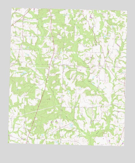
Tempy, GA USGS Topographic Map
Click on map above to begin viewing in our Map Viewer.

This topographic map contains these locations and features:
Feature Name Type Latitude Longitude GNIS ID View Map
Beulah ChurchChurchN31.4935°W83.8307°311268View Map
Briar BranchStreamN31.4143°W83.7655°311766View Map
Brown LakeReservoirN31.3775°W83.8224°341904View Map
Brown Lake DamDamN31.3768°W83.8199°341903View Map
Bull CreekStreamN31.3899°W83.7996°312014View Map
Carter LakeReservoirN31.3891°W83.8025°338336View Map
Carter Lake DamDamN31.3902°W83.8016°338335View Map
Emanuel ChurchChurchN31.4482°W83.8202°334752View Map
Evergreen CemeteryCemeteryN31.4341°W83.7871°314002View Map
Harrisonville CemeteryCemeteryN31.4277°W83.8527°349386View Map
Harrisonville School (historical)SchoolN31.4274°W83.8524°334756View Map
Horse CreekStreamN31.3832°W83.7855°315686View Map
Lumkins LakeReservoirN31.4368°W83.8432°341908View Map
Lumkins Lake DamDamN31.4368°W83.8432°341907View Map
New Bethel CemeteryCemeteryN31.4482°W83.7646°349394View Map
New Bethel CemeteryCemeteryN31.4896°W83.8630°319262View Map
New Bethel School (historical)SchoolN31.4482°W83.7641°334759View Map
Oak Grove CemeteryCemeteryN31.4705°W83.8296°349397View Map
Oak Grove ChurchChurchN31.4730°W83.8288°319772View Map
Oak Grove School (historical)SchoolN31.4732°W83.8299°334760View Map
Pine Forest ChurchChurchN31.4482°W83.7635°320555View Map
PowelltownPopulated PlaceN31.4096°W83.7846°326478View Map
Powelltown School (historical)SchoolN31.4102°W83.8032°334763View Map
Shingle Farm Service LakeReservoirN31.3968°W83.8049°341906View Map
Shingle Farm Service Lake DamDamN31.3968°W83.8049°341905View Map
Sizemore LakeReservoirN31.4760°W83.7735°341912View Map
Sizemore Lake DamDamN31.4768°W83.7749°341911View Map
Strickland DamDamN31.4418°W83.8582°338331View Map
Strickland LakeReservoirN31.4405°W83.8597°338332View Map
Sumner LakeReservoirN31.4935°W83.7892°341910View Map
Sumner Lake DamDamN31.4935°W83.7899°341909View Map
TempyPopulated PlaceN31.4488°W83.8174°326545View Map
Tempy CemeteryCemeteryN31.4482°W83.8202°349409View Map
Tempy Consolidated School (historical)SchoolN31.4488°W83.8199°352147View Map
Tempy Methodist ChurchChurchN31.4488°W83.8180°343351View Map
Thornhill CemeteryCemeteryN31.4680°W83.7810°324132View Map
Tiger Thicket CreekStreamN31.4349°W83.8357°324175View Map
Town CreekStreamN31.4730°W83.7960°324251View Map
Willis CemeteryCemeteryN31.4763°W83.8016°325391View Map
WSGY-FM (Tifton)TowerN31.4305°W83.7560°352800View Map
Zion Grove ChurchChurchN31.4099°W83.8030°325684View Map

Note: Coordinates in the location and feature list above are referenced to NAD83 datum.


Copyright (C) 2008-2025 Ryan Niemi / Sunset Dynamics ... All Rights Reserved