TopoQuest Logo
Do you find TopoQuest useful?
Help keep TopoQuest running and adding new maps/features by donating!
Bitcoin:  19c7KJd3qBynnjoSw5npx9KScwjBe4ifkT
Litecoin:  LXs6TkuXGGXo1vDsWCkWVdjQX94eUKd6ui
Home View Maps Find Maps Find Places Resources & Links


McCaskill, Arkansas Topographic Map

USGS Map Title: McCaskill, AR
USGS Map MRC: 33093H6
DRG (GeoTIFF) Download: o33093h6.tif


Neighboring USGS Topographic Map Quads:


  Nathan, AR  
34093A7
 

  Murfreesboro, AR  
34093A6
 

  Delight, AR  
34093A5
 

  Nashville, AR  
33093H7
 

  McCaskill, AR  
33093H6
 

  Pisgah, AR  
33093H5
 

  Columbus, AR  
33093G7
 

  Washington, AR  
33093G6
 

  Blevins, AR  
33093G5


Map MRC Location:

N34°
W94°
N34°
W93°
H8 H7 H6 H5 H4 H3 H2 H1
G8 G7 G6 G5 G4 G3 G2 G1
F8 F7 F6 F5 F4 F3 F2 F1
E8 E7 E6 E5 E4 E3 E2 E1
D8 D7 D6 D5 D4 D3 D2 D1
C8 C7 C6 C5 C4 C3 C2 C1
B8 B7 B6 B5 B4 B3 B2 B1
A8 A7 A6 A5 A4 A3 A2 A1
N33°
W94°
N33°
W93°

McCaskill, AR USGS 1:24K Topographic Map Preview:
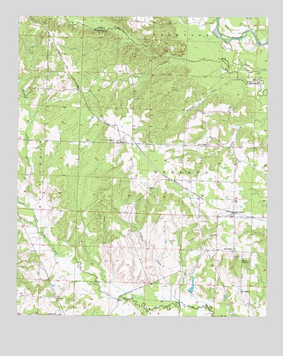
McCaskill, AR USGS Topographic Map
Click on map above to begin viewing in our Map Viewer.

This topographic map contains these locations and features:
Feature Name Type Latitude Longitude GNIS ID View Map
Avery Chapel United Methodist ChurchChurchN33.9462°W93.6555°76215View Map
Belton (historical)Populated PlaceN33.9487°W93.6988°61427View Map
Blevins School Number 2SchoolN33.8987°W93.6371°81976View Map
Brushy CreekStreamN33.9204°W93.7449°47075View Map
Bunker Hill School (historical)SchoolN33.8965°W93.6882°61423View Map
C J Erwin Estate Lake DamDamN33.9018°W93.7452°80716View Map
Erwin LakeReservoirN33.9018°W93.7452°80717View Map
Gaines BranchStreamN33.8804°W93.6688°49299View Map
Goff Chapel (historical)ChurchN33.8932°W93.6613°61424View Map
Golf ChapelChurchN33.9029°W93.6424°49486View Map
Howard CreekStreamN33.9743°W93.6405°50361View Map
Lake HarrisReservoirN33.9301°W93.6918°80711View Map
Lake Harris DamDamN33.9301°W93.6918°80710View Map
McCaskillPopulated PlaceN33.9168°W93.6416°51787View Map
McCaskill Volunteer Fire DepartmentBuildingN33.9474°W93.6899°2116778View Map
Mount Pleasant ChurchChurchN33.8859°W93.6374°77736View Map
New Home ChurchChurchN33.9473°W93.6955°52646View Map
Pleasant Grove Church (historical)ChurchN33.9321°W93.6638°61425View Map
Pond RunStreamN33.9123°W93.7405°78074View Map
Saint Peter ChurchChurchN33.8754°W93.7313°54464View Map
Stanley Lake Number OneReservoirN33.9201°W93.7302°80713View Map
Stanley Lake Number One DamDamN33.9201°W93.7302°80712View Map
Stanley Lake Number TwoReservoirN33.9101°W93.7485°80715View Map
Stanley Lake Number Two DamDamN33.9101°W93.7485°80714View Map
Town of McCaskillCivilN33.9186°W93.6417°2406122View Map
Township of RedlandCivilN33.9300°W93.6395°66646View Map
Westbrook (historical)Populated PlaceN33.9404°W93.6399°61426View Map
White Oak Church (historical)ChurchN33.8765°W93.6816°61550View Map
Young CemeteryCemeteryN33.9315°W93.6655°56612View Map

Note: Coordinates in the location and feature list above are referenced to NAD83 datum.


Copyright (C) 2008-2025 Ryan Niemi / Sunset Dynamics ... All Rights Reserved