TopoQuest Logo
Do you find TopoQuest useful?
Help keep TopoQuest running and adding new maps/features by donating!
Bitcoin:  19c7KJd3qBynnjoSw5npx9KScwjBe4ifkT
Litecoin:  LXs6TkuXGGXo1vDsWCkWVdjQX94eUKd6ui
Home View Maps Find Maps Find Places Resources & Links


Denmar, West Virginia Topographic Map

USGS Map Title: Denmar, WV
USGS Map MRC: 38080A2
DRG (GeoTIFF) Download: o38080a2.tif


Neighboring USGS Topographic Map Quads:


  Lobelia, WV  
38080B3
 

  Hillsboro, WV  
38080B2
 

  Marlinton, WV  
38080B1
 

  Droop, WV  
38080A3
 

  Denmar, WV  
38080A2
 

  Lake Sherwood, WV  
38080A1
 

  Anthony, WV  
37080H3
 

  Alvon, WV  
37080H2
 

  Rucker Gap, VA  
37080H1


Map MRC Location:

N39°
W81°
N39°
W80°
H8 H7 H6 H5 H4 H3 H2 H1
G8 G7 G6 G5 G4 G3 G2 G1
F8 F7 F6 F5 F4 F3 F2 F1
E8 E7 E6 E5 E4 E3 E2 E1
D8 D7 D6 D5 D4 D3 D2 D1
C8 C7 C6 C5 C4 C3 C2 C1
B8 B7 B6 B5 B4 B3 B2 B1
A8 A7 A6 A5 A4 A3 A2 A1
N38°
W81°
N38°
W80°

Denmar, WV USGS 1:24K Topographic Map Preview:
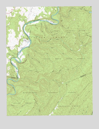
Denmar, WV USGS Topographic Map
Click on map above to begin viewing in our Map Viewer.

This topographic map contains these locations and features:
Feature Name Type Latitude Longitude GNIS ID View Map
Arrowhead TrailTrailN38.1129°W80.1712°1550116View Map
Bear Pen Run TrailTrailN38.1193°W80.1273°1550186View Map
BeardPopulated PlaceN38.0768°W80.2273°1550200View Map
Beaver Lick MountainRidgeN38.0204°W80.1470°1550222View Map
Buck and Doe TrailTrailN38.1240°W80.1270°1550068View Map
Burnside RidgeRidgeN38.0923°W80.1642°1550565View Map
BurnsidesPopulated PlaceN38.1085°W80.2084°1550566View Map
Calvin Price State ForestForestN38.0637°W80.1517°1550590View Map
Crowser HollowValleyN38.1043°W80.2078°1550851View Map
Davy RunStreamN38.0323°W80.2387°1550882View Map
DenmarPopulated PlaceN38.0862°W80.2223°1554289View Map
Denmar Correctional CenterBuildingN38.0862°W80.2209°2634738View Map
Denmar School (historical)SchoolN38.0832°W80.2265°1728040View Map
Denmar State Hospital (historical)HospitalN38.0862°W80.2209°1728041View Map
Hatten RunStreamN38.1090°W80.1998°1551389View Map
Island Lick RunStreamN38.1179°W80.1751°1551549View Map
Jackson Farm SpringSpringN38.1043°W80.2428°1558114View Map
KennisonPopulated PlaceN38.1076°W80.1859°1554860View Map
Kennison RunStreamN38.0796°W80.1412°1551635View Map
Laurel RunStreamN38.0898°W80.2167°1551740View Map
LocustPopulated PlaceN38.0676°W80.2387°1551910View Map
Locust CreekStreamN38.0665°W80.2384°1551911View Map
Locust Creek School (historical)SchoolN38.1018°W80.2495°1728101View Map
Long Day RunStreamN38.0385°W80.2034°1553619View Map
Maple Grove School (historical)SchoolN38.0637°W80.2476°1728104View Map
Mill RunStreamN38.1054°W80.2217°1552115View Map
Mill RunStreamN38.1082°W80.1942°1552116View Map
Mill Run (historical)Populated PlaceN38.1054°W80.2217°1728114View Map
Nigh Gap RunStreamN38.0707°W80.2259°1552309View Map
Old Droop ChurchChurchN38.0637°W80.2470°1552374View Map
Oldham RunStreamN38.0660°W80.2303°1552384View Map
Perry RunStreamN38.0779°W80.2128°1552457View Map
Pond RidgeRidgeN38.0804°W80.1715°1552538View Map
Pyle MountainSummitN38.0932°W80.1362°1555425View Map
Rock RunStreamN38.1048°W80.1753°1552701View Map
Slabcamp MountainSummitN38.0190°W80.2109°1552912View Map
Spice RidgeRidgeN38.0493°W80.1853°1552992View Map
Spice Ridge TrailTrailN38.0501°W80.1923°1552993View Map
Spice RunLocaleN38.0510°W80.2348°1560602View Map
Spice RunStreamN38.0432°W80.2331°1552994View Map
Spice Run WildernessReserveN38.0359°W80.1983°2767383View Map
Trump RunStreamN38.0679°W80.2376°1553274View Map
Watoga LakeReservoirN38.1179°W80.1267°1559219View Map
Watoga State ParkParkN38.1037°W80.1501°1553392View Map

Note: Coordinates in the location and feature list above are referenced to NAD83 datum.


Copyright (C) 2008-2025 Ryan Niemi / Sunset Dynamics ... All Rights Reserved