TopoQuest Logo
Do you find TopoQuest useful?
Help keep TopoQuest running and adding new maps/features by donating!
Bitcoin:  19c7KJd3qBynnjoSw5npx9KScwjBe4ifkT
Litecoin:  LXs6TkuXGGXo1vDsWCkWVdjQX94eUKd6ui
Home View Maps Find Maps Find Places Resources & Links


Dudley, Missouri Topographic Map

USGS Map Title: Dudley, MO
USGS Map MRC: 36090G1
DRG (GeoTIFF) Download: o36090g1.tif


Neighboring USGS Topographic Map Quads:


  Puxico, MO  
36090H2
 

  Acorn Ridge, MO  
36090H1
 

  Bloomfield, MO  
36089H8
 

  Fisk, MO  
36090G2
 

  Dudley, MO  
36090G1
 

  Dexter, MO  
36089G8
 

  Broseley, MO  
36090F2
 

  Powe, MO  
36090F1
 

  Bernie, MO  
36089F8


Map MRC Location:

N37°
W91°
N37°
W90°
H8 H7 H6 H5 H4 H3 H2 H1
G8 G7 G6 G5 G4 G3 G2 G1
F8 F7 F6 F5 F4 F3 F2 F1
E8 E7 E6 E5 E4 E3 E2 E1
D8 D7 D6 D5 D4 D3 D2 D1
C8 C7 C6 C5 C4 C3 C2 C1
B8 B7 B6 B5 B4 B3 B2 B1
A8 A7 A6 A5 A4 A3 A2 A1
N36°
W91°
N36°
W90°

Dudley, MO USGS 1:24K Topographic Map Preview:
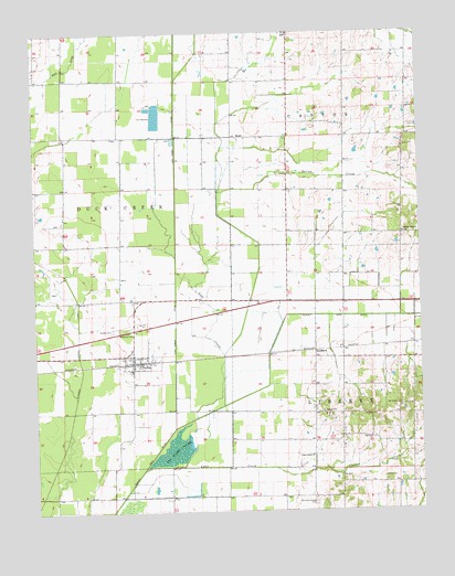
Dudley, MO USGS Topographic Map
Click on map above to begin viewing in our Map Viewer.

This topographic map contains these locations and features:
Feature Name Type Latitude Longitude GNIS ID View Map
Ajax (historical)LocaleN36.7898°W90.0718°747638View Map
Armstead Dowdy CemeteryCemeteryN36.7517°W90.0354°713387View Map
Avis Fishing Lake DamDamN36.8084°W90.0751°765547View Map
Cane CreekStreamN36.7608°W90.0909°715341View Map
Cane Creek ChurchChurchN36.7645°W90.0356°715346View Map
City of DudleyCivilN36.7897°W90.0916°2394566View Map
Cypress Lateral Number 1CanalN36.7901°W90.1109°755044View Map
Cypress School (historical)SchoolN36.7542°W90.1187°747635View Map
Dowdy SchoolSchoolN36.7503°W90.0445°747641View Map
DudleyPopulated PlaceN36.7887°W90.0932°717148View Map
Dudley AirportAirportN36.7831°W90.0931°2679321View Map
Dudley CemeteryCemeteryN36.7975°W90.1001°717149View Map
Dudley Main DitchCanalN36.8006°W90.0440°717151View Map
Dudley Post OfficePost OfficeN36.7935°W90.0918°2782885View Map
Dudley Volunteer Fire DepartmentBuildingN36.7925°W90.0906°2621535View Map
Garner School (historical)SchoolN36.7770°W90.0070°747640View Map
Greenwood SchoolSchoolN36.8226°W90.0234°747637View Map
Howell SchoolSchoolN36.7789°W90.0337°747639View Map
Lovins Lake DamDamN36.7751°W90.0051°765549View Map
Melton School (historical)SchoolN36.8701°W90.0970°747633View Map
Mule DitchCanalN36.8731°W90.1098°723053View Map
Old Bethel CemeteryCemeteryN36.7775°W90.0065°723715View Map
Orchard LakeReservoirN36.7751°W90.0051°765550View Map
ReddPopulated PlaceN36.8478°W90.0607°741190View Map
Sadlers ChapelChurchN36.8226°W90.0054°725711View Map
Sherry SchoolSchoolN36.8517°W90.0334°747636View Map
Smith CemeteryCemeteryN36.7587°W90.0129°726583View Map
Spring CreekStreamN36.7909°W90.0643°726902View Map
StoddardPopulated PlaceN36.7914°W90.0343°741296View Map
The Glades SwampSwampN36.7659°W90.0795°727553View Map
Walter Avis LakeReservoirN36.8084°W90.0751°765548View Map
Wilkerson SchoolSchoolN36.8273°W90.1145°747634View Map

Note: Coordinates in the location and feature list above are referenced to NAD83 datum.


Copyright (C) 2008-2024 Ryan Niemi / Sunset Dynamics ... All Rights Reserved