TopoQuest Logo
Do you find TopoQuest useful?
Help keep TopoQuest running and adding new maps/features by donating!
Bitcoin:  19c7KJd3qBynnjoSw5npx9KScwjBe4ifkT
Litecoin:  LXs6TkuXGGXo1vDsWCkWVdjQX94eUKd6ui
Home View Maps Find Maps Find Places Resources & Links


Bernie, Missouri Topographic Map

USGS Map Title: Bernie, MO
USGS Map MRC: 36089F8
DRG (GeoTIFF) Download: o36089f8.tif


Neighboring USGS Topographic Map Quads:


  Dudley, MO  
36090G1
 

  Dexter, MO  
36089G8
 

  Essex, MO  
36089G7
 

  Powe, MO  
36090F1
 

  Bernie, MO  
36089F8
 

  Hills Store, MO  
36089F7
 

  Valley Ridge, MO  
36090E1
 

  Malden, MO  
36089E8
 

  Parma, MO  
36089E7


Map MRC Location:

N37°
W90°
N37°
W89°
H8 H7 H6 H5 H4 H3 H2 H1
G8 G7 G6 G5 G4 G3 G2 G1
F8 F7 F6 F5 F4 F3 F2 F1
E8 E7 E6 E5 E4 E3 E2 E1
D8 D7 D6 D5 D4 D3 D2 D1
C8 C7 C6 C5 C4 C3 C2 C1
B8 B7 B6 B5 B4 B3 B2 B1
A8 A7 A6 A5 A4 A3 A2 A1
N36°
W90°
N36°
W89°

Bernie, MO USGS 1:24K Topographic Map Preview:
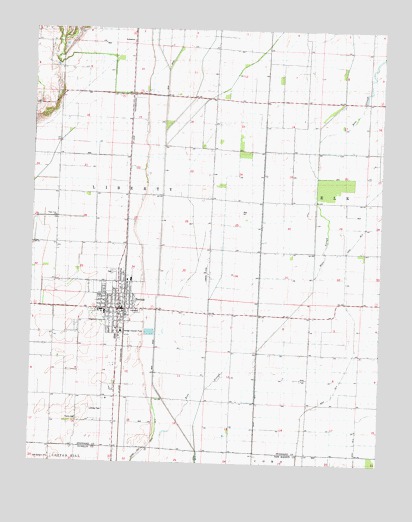
Bernie, MO USGS Topographic Map
Click on map above to begin viewing in our Map Viewer.

This topographic map contains these locations and features:
Feature Name Type Latitude Longitude GNIS ID View Map
BerniePopulated PlaceN36.6689°W89.9687°713988View Map
Bernie Fire DepartmentBuildingN36.6699°W89.9693°2621531View Map
Bernie Police DepartmentBuildingN36.6701°W89.9690°2752185View Map
Bernie Post OfficePost OfficeN36.6685°W89.9682°2783143View Map
Bess SloughStreamN36.6370°W89.9470°714005View Map
Bunker HillPopulated PlaceN36.7059°W89.9698°738304View Map
Bunker Hill School (historical)SchoolN36.7056°W89.9679°746876View Map
City of BernieCivilN36.6717°W89.9707°2394150View Map
Dickerson School (historical)LocaleN36.6976°W89.9187°742633View Map
Guide Star SchoolSchoolN36.7401°W89.9101°742629View Map
HazelLocaleN36.7437°W89.9640°746874View Map
Lampher Chapel (historical)ChurchN36.6639°W89.9004°746879View Map
Last Chance Church (historical)ChurchN36.7023°W89.9820°746877View Map
Liberty Corner Church (historical)ChurchN36.7148°W89.9079°746878View Map
Main DitchCanalN36.7139°W89.9534°721764View Map
Miller (historical)Populated PlaceN36.7209°W89.9662°742631View Map
New Hope Church (historical)ChurchN36.6417°W89.8834°742637View Map
New Prospect ChurchChurchN36.6262°W89.9931°730167View Map
Oak Grove School (historical)LocaleN36.7312°W89.9345°742630View Map
Out (historical)LocaleN36.7131°W89.9656°740291View Map
Poplin CemeteryCemeteryN36.6373°W89.9829°724754View Map
Poplin SchoolLocaleN36.6373°W89.9837°742634View Map
Smith School (historical)LocaleN36.6489°W89.9009°742635View Map
Smith School (historical)LocaleN36.6420°W89.8956°742636View Map
Sugar Tree ChurchChurchN36.6956°W89.9915°727249View Map
Sugar Tree SchoolSchoolN36.6948°W89.9906°742632View Map
Sweet Prospect Church (historical)ChurchN36.7442°W89.9168°742628View Map

Note: Coordinates in the location and feature list above are referenced to NAD83 datum.


Copyright (C) 2008-2024 Ryan Niemi / Sunset Dynamics ... All Rights Reserved