TopoQuest Logo
Do you find TopoQuest useful?
Help keep TopoQuest running and adding new maps/features by donating!
Bitcoin:  19c7KJd3qBynnjoSw5npx9KScwjBe4ifkT
Litecoin:  LXs6TkuXGGXo1vDsWCkWVdjQX94eUKd6ui
Home View Maps Find Maps Find Places Resources & Links


Plymouth, Maine Topographic Map

USGS Map Title: Plymouth, ME
USGS Map MRC: 44069G2
DRG (GeoTIFF) Download: o44069g2.tif


Neighboring USGS Topographic Map Quads:


  Corinna, ME  
44069H3
 

  Stetson, ME  
44069H2
 

  West Corinth, ME  
44069H1
 

  Newport, ME  
44069G3
 

  Plymouth, ME  
44069G2
 

  Carmel, ME  
44069G1
 

  Unity Pond, ME  
44069F3
 

  Dixmont, ME  
44069F2
 

  East Dixmont, ME  
44069F1


Map MRC Location:

N45°
W70°
N45°
W69°
H8 H7 H6 H5 H4 H3 H2 H1
G8 G7 G6 G5 G4 G3 G2 G1
F8 F7 F6 F5 F4 F3 F2 F1
E8 E7 E6 E5 E4 E3 E2 E1
D8 D7 D6 D5 D4 D3 D2 D1
C8 C7 C6 C5 C4 C3 C2 C1
B8 B7 B6 B5 B4 B3 B2 B1
A8 A7 A6 A5 A4 A3 A2 A1
N44°
W70°
N44°
W69°

Plymouth, ME USGS 1:24K Topographic Map Preview:
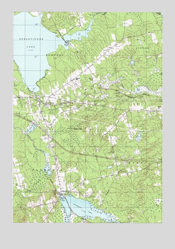
Plymouth, ME USGS Topographic Map
Click on map above to begin viewing in our Map Viewer.

This topographic map contains these locations and features:
Feature Name Type Latitude Longitude GNIS ID View Map
Abbott HillSummitN44.8186°W69.1304°561052View Map
Billings HillPopulated PlaceN44.8362°W69.1978°579135View Map
Christies CampgroundLocaleN44.8270°W69.2339°1913401View Map
Durham BridgeBridgeN44.8571°W69.2055°565435View Map
East NewportPopulated PlaceN44.8209°W69.2225°579278View Map
East Newport Post OfficePost OfficeN44.8199°W69.2205°1913483View Map
Emmanuel ChurchChurchN44.7670°W69.2078°1913498View Map
Hall CemeteryCemeteryN44.8319°W69.1974°2736918View Map
Interchange 41CrossingN44.8017°W69.2206°1913617View Map
Moosehead TrailTrailN44.7887°W69.2153°571642View Map
Mud PondLakeN44.8285°W69.1456°571902View Map
Newport Sky ParkAirportN44.8217°W69.2365°582191View Map
Palmer CemeteryCemeteryN44.8359°W69.1839°572941View Map
Pleasant Lake Shores CampgroundLocaleN44.8681°W69.1259°1913827View Map
PlymouthPopulated PlaceN44.7673°W69.2103°573539View Map
Plymouth BogSwampN44.7834°W69.2314°573540View Map
Plymouth Fire and Rescue DepartmentBuildingN44.7690°W69.2123°2552721View Map
Plymouth PondReservoirN44.7580°W69.1919°573541View Map
Plymouth Pond DamDamN44.7670°W69.2102°1773721View Map
Plymouth Post OfficePost OfficeN44.7685°W69.2096°1913829View Map
Sebasticook LakeReservoirN44.8577°W69.2418°575163View Map
Stetson StreamStreamN44.8706°W69.1831°576312View Map
Stuart CemeteryCemeteryN44.8165°W69.1455°2727067View Map
Tent Village CampgroundLocaleN44.8326°W69.2303°1913930View Map
Town of EtnaCivilN44.7853°W69.1337°582468View Map
Town of NewportCivilN44.8603°W69.2329°582621View Map
Town of PlymouthCivilN44.7702°W69.2246°582679View Map
Washington SchoolSchoolN44.8090°W69.1625°577863View Map
Woodman BrookStreamN44.7609°W69.1750°578683View Map

Note: Coordinates in the location and feature list above are referenced to NAD83 datum.


Copyright (C) 2008-2025 Ryan Niemi / Sunset Dynamics ... All Rights Reserved