TopoQuest Logo
Do you find TopoQuest useful?
Help keep TopoQuest running and adding new maps/features by donating!
Bitcoin:  19c7KJd3qBynnjoSw5npx9KScwjBe4ifkT
Litecoin:  LXs6TkuXGGXo1vDsWCkWVdjQX94eUKd6ui
Home View Maps Find Maps Find Places Resources & Links


Carmel, Maine Topographic Map

USGS Map Title: Carmel, ME
USGS Map MRC: 44069G1
DRG (GeoTIFF) Download: o44069g1.tif


Neighboring USGS Topographic Map Quads:


  Stetson, ME  
44069H2
 

  West Corinth, ME  
44069H1
 

  Kenduskeag, ME  
44068H8
 

  Plymouth, ME  
44069G2
 

  Carmel, ME  
44069G1
 

  Hermon, ME  
44068G8
 

  Dixmont, ME  
44069F2
 

  East Dixmont, ME  
44069F1
 

  Snow Mountain, ME  
44068F8


Map MRC Location:

N45°
W70°
N45°
W69°
H8 H7 H6 H5 H4 H3 H2 H1
G8 G7 G6 G5 G4 G3 G2 G1
F8 F7 F6 F5 F4 F3 F2 F1
E8 E7 E6 E5 E4 E3 E2 E1
D8 D7 D6 D5 D4 D3 D2 D1
C8 C7 C6 C5 C4 C3 C2 C1
B8 B7 B6 B5 B4 B3 B2 B1
A8 A7 A6 A5 A4 A3 A2 A1
N44°
W70°
N44°
W69°

Carmel, ME USGS 1:24K Topographic Map Preview:
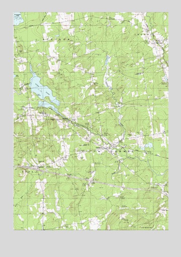
Carmel, ME USGS Topographic Map
Click on map above to begin viewing in our Map Viewer.

This topographic map contains these locations and features:
Feature Name Type Latitude Longitude GNIS ID View Map
Buzzell StreamStreamN44.8348°W69.1098°563323View Map
Camp EtnaLocaleN44.8176°W69.1014°1913375View Map
Caravel Middle SchoolSchoolN44.8400°W69.0223°1913377View Map
CarmelPopulated PlaceN44.7976°W69.0512°563576View Map
Carmel Bible ConferenceChurchN44.7992°W69.0639°1913379View Map
Carmel Elementary SchoolSchoolN44.7953°W69.0559°1913380View Map
Carmel Fire Department and RescueBuildingN44.7981°W69.0551°2553016View Map
Carmel Post OfficePost OfficeN44.7994°W69.0594°1913381View Map
Carmel Valley Golf ClubLocaleN44.8020°W69.0550°1913382View Map
Coboro CemeteryCemeteryN44.8517°W69.1188°564129View Map
DamascusPopulated PlaceN44.8123°W69.0806°564758View Map
EtnaPopulated PlaceN44.8209°W69.1112°579300View Map
Etna BogSwampN44.7659°W69.1217°565947View Map
Etna CemeteryCemeteryN44.8145°W69.1197°565948View Map
Etna CenterPopulated PlaceN44.7867°W69.1059°579301View Map
Etna PondLakeN44.8291°W69.1013°565949View Map
Etna Post OfficePost OfficeN44.8160°W69.1082°2768977View Map
Etna Volunteer Fire DepartmentBuildingN44.8154°W69.1177°2552799View Map
Etna Volunteer Fire DepartmentBuildingN44.8154°W69.1178°2553070View Map
Glory ChapelChurchN44.7967°W69.0550°1914005View Map
Harvey StreamStreamN44.7973°W69.0364°567727View Map
Highland CemeteryCemeteryN44.8048°W69.0278°568034View Map
Hill BrookStreamN44.7817°W69.0092°568047View Map
Interchange 42CrossingN44.7853°W69.1056°1913618View Map
Longfellow SchoolSchoolN44.7573°W69.1014°570330View Map
Lost PondLakeN44.8383°W69.1240°570400View Map
North Carmel CemeteryCemeteryN44.8332°W69.0000°2736931View Map
Pleasant Hill CemeteryCemeteryN44.7894°W69.1051°573484View Map
Ring Hill AirportAirportN44.7917°W69.0720°582128View Map
Simpson Memorial LibraryBuildingN44.7967°W69.0517°2738430View Map
South LevantPopulated PlaceN44.8576°W69.0106°579720View Map
South Levant Baptist ChurchChurchN44.8545°W69.0106°1913901View Map
Town of CarmelCivilN44.7969°W69.0313°582390View Map
Tracy BrookStreamN44.7915°W69.0320°577253View Map
Village CemeteryCemeteryN44.7972°W69.0484°2727070View Map

Note: Coordinates in the location and feature list above are referenced to NAD83 datum.


Copyright (C) 2008-2024 Ryan Niemi / Sunset Dynamics ... All Rights Reserved