TopoQuest Logo
Do you find TopoQuest useful?
Help keep TopoQuest running and adding new maps/features by donating!
Bitcoin:  19c7KJd3qBynnjoSw5npx9KScwjBe4ifkT
Litecoin:  LXs6TkuXGGXo1vDsWCkWVdjQX94eUKd6ui
Home View Maps Find Maps Find Places Resources & Links


Dogwood Peak, California Topographic Map

USGS Map Title: Dogwood Peak, CA
USGS Map MRC: 39121G1
DRG (GeoTIFF) Download: o39121g1.tif


Neighboring USGS Topographic Map Quads:


  Bucks Lake, CA  
39121H2
 

  Meadow Valley, CA  
39121H1
 

  Quincy, CA  
39120H8
 

  Haskins Valley, CA  
39121G2
 

  Dogwood Peak, CA  
39121G1
 

  Onion Valley, CA  
39120G8
 

  Cascade, CA  
39121F2
 

  American House, CA  
39121F1
 

  La Porte, CA  
39120F8


Map MRC Location:

N40°
W122°
N40°
W121°
H8 H7 H6 H5 H4 H3 H2 H1
G8 G7 G6 G5 G4 G3 G2 G1
F8 F7 F6 F5 F4 F3 F2 F1
E8 E7 E6 E5 E4 E3 E2 E1
D8 D7 D6 D5 D4 D3 D2 D1
C8 C7 C6 C5 C4 C3 C2 C1
B8 B7 B6 B5 B4 B3 B2 B1
A8 A7 A6 A5 A4 A3 A2 A1
N39°
W122°
N39°
W121°

Dogwood Peak, CA USGS 1:24K Topographic Map Preview:
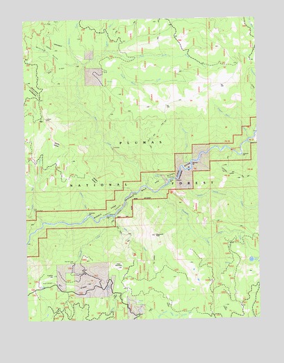
Dogwood Peak, CA USGS Topographic Map
Click on map above to begin viewing in our Map Viewer.

This topographic map contains these locations and features:
Feature Name Type Latitude Longitude GNIS ID View Map
Bear CreekStreamN39.8057°W121.0608°256634View Map
Bottle SpringsSpringN39.8641°W121.0008°257372View Map
Butte BarBarN39.8071°W121.0480°257759View Map
Carpenter BarBarN39.7935°W121.0908°257988View Map
Carpenter CreekStreamN39.7938°W121.0925°257989View Map
Cleghorn BarBarN39.8182°W121.0091°258446View Map
Cleghorn Bar CampgroundLocaleN39.8199°W121.0147°258447View Map
Deadman SpringSpringN39.8090°W121.0570°259142View Map
Dejonah CreekStreamN39.7932°W121.0816°259257View Map
Dejonah Creek MineMineN39.7735°W121.1005°259258View Map
Dogwood CreekStreamN39.8029°W121.0550°259450View Map
Dogwood PeakSummitN39.7849°W121.0563°259454View Map
Fourth Water CreekStreamN39.8579°W121.0880°260315View Map
Fowler CreekStreamN39.7832°W121.0311°266268View Map
Fowler LakeLakeN39.7741°W121.0052°260318View Map
Franklin CanyonValleyN39.7902°W121.0977°260337View Map
Franklin HillSummitN39.7685°W121.1116°260340View Map
Hartman Bar RidgeRidgeN39.7638°W121.1011°261123View Map
Last Chance CreekStreamN39.8235°W121.0058°262330View Map
Little Bear CreekStreamN39.7907°W121.1172°262524View Map
Little California MineMineN39.7960°W121.1227°262559View Map
Lookout RockPillarN39.8338°W121.1144°262911View Map
McFarland RavineValleyN39.8582°W121.0961°263343View Map
Miller ForkStreamN39.8613°W121.0813°267015View Map
Morrow CreekStreamN39.8560°W121.0930°263851View Map
Onion Valley CreekStreamN39.8082°W121.0444°267095View Map
Pidgeon Roost CreekStreamN39.8246°W121.0058°264707View Map
Red RidgeRidgeN39.8543°W121.1077°265315View Map
Sherman BarBarN39.8146°W121.0363°266104View Map
Stag CreekStreamN39.7927°W121.0788°266269View Map
Stag PointCapeN39.7929°W121.0808°267657View Map
Table MountainSummitN39.7716°W121.0766°268050View Map
Third Water CreekStreamN39.8560°W121.0930°268222View Map

Note: Coordinates in the location and feature list above are referenced to NAD83 datum.


Copyright (C) 2008-2025 Ryan Niemi / Sunset Dynamics ... All Rights Reserved