TopoQuest Logo
Do you find TopoQuest useful?
Help keep TopoQuest running and adding new maps/features by donating!
Bitcoin:  19c7KJd3qBynnjoSw5npx9KScwjBe4ifkT
Litecoin:  LXs6TkuXGGXo1vDsWCkWVdjQX94eUKd6ui
Home View Maps Find Maps Find Places Resources & Links


Dutch Flat, California Topographic Map

USGS Map Title: Dutch Flat, CA
USGS Map MRC: 39120B7
DRG (GeoTIFF) Download: o39120b7.tif


Neighboring USGS Topographic Map Quads:


  North Bloomfield, CA  
39120C8
 

  Washington, CA  
39120C7
 

  Blue Canyon, CA  
39120C6
 

  Chicago Park, CA  
39120B8
 

  Dutch Flat, CA  
39120B7
 

  Westville, CA  
39120B6
 

  Colfax, CA  
39120A8
 

  Foresthill, CA  
39120A7
 

  Michigan Bluff, CA  
39120A6


Map MRC Location:

N40°
W121°
N40°
W120°
H8 H7 H6 H5 H4 H3 H2 H1
G8 G7 G6 G5 G4 G3 G2 G1
F8 F7 F6 F5 F4 F3 F2 F1
E8 E7 E6 E5 E4 E3 E2 E1
D8 D7 D6 D5 D4 D3 D2 D1
C8 C7 C6 C5 C4 C3 C2 C1
B8 B7 B6 B5 B4 B3 B2 B1
A8 A7 A6 A5 A4 A3 A2 A1
N39°
W121°
N39°
W120°

Dutch Flat, CA USGS 1:24K Topographic Map Preview:
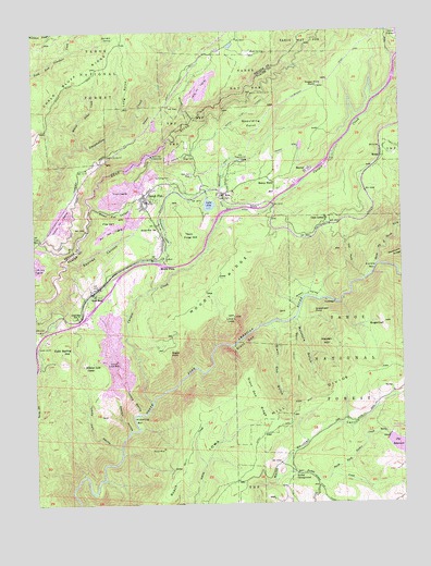
Dutch Flat, CA USGS Topographic Map
Click on map above to begin viewing in our Map Viewer.

This topographic map contains these locations and features:
Feature Name Type Latitude Longitude GNIS ID View Map
AltaPopulated PlaceN39.2066°W120.8113°256205View Map
Alta - Dutch Flat Elementary SchoolSchoolN39.2075°W120.8079°1723334View Map
Alta Census Designated PlaceCensusN39.2138°W120.8033°2628704View Map
Alta PowerhouseLocaleN39.2160°W120.8030°1654155View Map
Alta Vista Post OfficePost OfficeN39.2090°W120.8155°2769318View Map
Alta Volunteer Fire Protection DistrictBuildingN39.2070°W120.8104°1662419View Map
BaxterPopulated PlaceN39.2130°W120.7810°1655815View Map
Big Meadow CampgroundLocaleN39.1438°W120.7547°274922View Map
Big ReservoirReservoirN39.1402°W120.7531°256992View Map
Blue Devil DiggingsMineN39.1980°W120.8502°257238View Map
Bogus PointSummitN39.1655°W120.8302°1655837View Map
Bonny NookLocaleN39.2102°W120.7944°257345View Map
California Highway Patrol Valley Division - Gold RunBuildingN39.1883°W120.8346°2770088View Map
Camel HumpSummitN39.2168°W120.8511°1682852View Map
Camels Hump LookoutLocaleN39.2168°W120.8508°257839View Map
Canyon CreekStreamN39.1518°W120.8363°257944View Map
Casa LomaPopulated PlaceN39.2005°W120.7766°1655874View Map
Christmas Hill DiggingsMineN39.2007°W120.8666°258354View Map
Cold Spring HillSummitN39.1671°W120.8644°258559View Map
Drum (historical)Populated PlaceN39.2491°W120.7535°1701154View Map
Dutch FlatPopulated PlaceN39.2060°W120.8377°259631View Map
Dutch Flat 2 Forebay 61-024 DamDamN39.2240°W120.8349°1663492View Map
Dutch Flat Afterbay 61-023 DamDamN39.2132°W120.8444°1663491View Map
Dutch Flat CanyonValleyN39.2041°W120.8566°259632View Map
Dutch Flat CemeteryCemeteryN39.2054°W120.8344°1723341View Map
Dutch Flat Census Designated PlaceCensusN39.2080°W120.8345°2628726View Map
Dutch Flat Post OfficePost OfficeN39.2067°W120.8385°2769354View Map
Dutch Flat PowerhouseLocaleN39.2168°W120.8355°1654239View Map
Dutch Flat StationLocaleN39.1921°W120.8322°259634View Map
Dutch Flat TunnelTunnelN39.2288°W120.8013°259635View Map
Euchre BarBarN39.1871°W120.7599°259973View Map
Forbes CampgroundLocaleN39.1327°W120.7874°260236View Map
Forbes CreekStreamN39.1305°W120.7958°260237View Map
Forbes Creek Group CampgroundLocaleN39.1310°W120.7830°274924View Map
Frost HillSummitN39.1949°W120.8213°1656037View Map
FS Water Treatment PlantLocaleN39.1257°W120.7974°274925View Map
Giant GapGapN39.1682°W120.8060°260541View Map
Giant Gap Family CampgroundLocaleN39.1371°W120.7944°274919View Map
Giant Gap GulchValleyN39.1727°W120.7958°260542View Map
Giant Gap RidgeRidgeN39.1516°W120.7997°224146View Map
Gold RunPopulated PlaceN39.1807°W120.8558°260662View Map
Gold Run Post OfficePost OfficeN39.1806°W120.8552°2769427View Map
Gold Run SchoolSchoolN39.1752°W120.8611°260664View Map
Green ValleyValleyN39.1771°W120.7858°260866View Map
Green Valley TrailTrailN39.1616°W120.7877°260869View Map
Hayden HillSummitN39.1671°W120.7758°1656064View Map
Hidden Gold CampLocaleN39.1618°W120.8594°261296View Map
Indiana RavineValleyN39.1488°W120.8410°261781View Map
Iron PointCapeN39.1910°W120.7683°261818View Map
Lake AltaLakeN39.2040°W120.8163°256209View Map
Lake Alta 97-026 DamDamN39.2049°W120.8144°1663603View Map
Liberty Hill DamDamN39.2466°W120.8094°1664703View Map
Liberty Hill DiggingsMineN39.2352°W120.8183°262434View Map
Liberty Hill ReservoirReservoirN39.2460°W120.8085°1664704View Map
Little Bear CreekStreamN39.2168°W120.8366°1701168View Map
Long PointCapeN39.2341°W120.8436°262864View Map
Lovers LeapCliffN39.1746°W120.8077°262985View Map
McIntyre GulchValleyN39.1741°W120.7877°263372View Map
MidasPopulated PlaceN39.2166°W120.7577°1656165View Map
Million Dollar CreekStreamN39.2196°W120.8608°263645View Map
Monte VistaPopulated PlaceN39.1866°W120.8327°1656176View Map
Monzarita Day Use CampgroundLocaleN39.1413°W120.7866°274921View Map
Moody RidgeRidgeN39.1835°W120.8141°229004View Map
Morning Star Reservoir 325 DamDamN39.1416°W120.7560°1663830View Map
Mule SpringSpringN39.2445°W120.8011°263955View Map
Narry Red MineMineN39.2113°W120.8224°264003View Map
Nichols DiggingsMineN39.2080°W120.8463°264086View Map
North Fork North Fork American RiverStreamN39.1882°W120.7594°264130View Map
ORV Staging AreaLocaleN39.1285°W120.7594°276204View Map
Pickering BarBarN39.1480°W120.8427°264699View Map
Placer County Fire Department Station 32 / Dutch Flat Volunteer Fire DepartmentBuildingN39.2054°W120.8392°2621887View Map
Pug UglyFlatN39.1996°W120.8474°265054View Map
Pulp Mill DitchCanalN39.2032°W120.8074°265056View Map
Red Hill SpringSpringN39.2480°W120.8482°265282View Map
Roach HillSummitN39.1357°W120.8252°1656259View Map
Sheldon RavineValleyN39.1443°W120.8441°266084View Map
Shirttail Creek Family CampgroundLocaleN39.1443°W120.7858°274920View Map
Snakehead PointSummitN39.1755°W120.7808°267297View Map
Spaulding PointSummitN39.2255°W120.8002°1656325View Map
Squires CanyonValleyN39.1885°W120.8655°267641View Map
Stewart Gravel MineMineN39.1630°W120.8480°267742View Map
Stump CanyonValleyN39.2266°W120.8213°235622View Map
Sugar Pine Beat RampLocaleN39.1313°W120.7913°1662418View Map
Sugar Pine PointLocaleN39.2355°W120.7777°267848View Map
Sugar Pine ReservoirReservoirN39.1339°W120.7921°274923View Map
SugarloafSummitN39.1724°W120.7572°267864View Map
Tommy Cain RavineValleyN39.1396°W120.8472°268346View Map
TowlePopulated PlaceN39.2041°W120.7991°1656369View Map
Trail Spur (historical)LocaleN39.2024°W120.7635°1701191View Map
Upper Boardmen CanalCanalN39.2463°W120.7680°274926View Map

Note: Coordinates in the location and feature list above are referenced to NAD83 datum.


Copyright (C) 2008-2025 Ryan Niemi / Sunset Dynamics ... All Rights Reserved