TopoQuest Logo
Do you find TopoQuest useful?
Help keep TopoQuest running and adding new maps/features by donating!
Bitcoin:  19c7KJd3qBynnjoSw5npx9KScwjBe4ifkT
Litecoin:  LXs6TkuXGGXo1vDsWCkWVdjQX94eUKd6ui
Home View Maps Find Maps Find Places Resources & Links


East Butler, Pennsylvania Topographic Map

USGS Map Title: East Butler, PA
USGS Map MRC: 40079H7
DRG (GeoTIFF) Download: o40079h7.tif


Neighboring USGS Topographic Map Quads:


  West Sunbury, PA  
41079A8
 

  Hilliards, PA  
41079A7
 

  Parker, PA  
41079A6
 

  Mount Chestnut, PA  
40079H8
 

  East Butler, PA  
40079H7
 

  Chicora, PA  
40079H6
 

  Butler, PA  
40079G8
 

  Saxonburg, PA  
40079G7
 

  Worthington, PA  
40079G6


Map MRC Location:

N41°
W80°
N41°
W79°
H8 H7 H6 H5 H4 H3 H2 H1
G8 G7 G6 G5 G4 G3 G2 G1
F8 F7 F6 F5 F4 F3 F2 F1
E8 E7 E6 E5 E4 E3 E2 E1
D8 D7 D6 D5 D4 D3 D2 D1
C8 C7 C6 C5 C4 C3 C2 C1
B8 B7 B6 B5 B4 B3 B2 B1
A8 A7 A6 A5 A4 A3 A2 A1
N40°
W80°
N40°
W79°

East Butler, PA USGS 1:24K Topographic Map Preview:
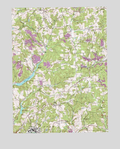
East Butler, PA USGS Topographic Map
Click on map above to begin viewing in our Map Viewer.

This topographic map contains these locations and features:
Feature Name Type Latitude Longitude GNIS ID View Map
Borough of East ButlerCivilN40.8788°W79.8473°1214990View Map
BoydstownPopulated PlaceN40.9378°W79.8462°1170087View Map
Boydstown DamDamN40.9384°W79.8431°1195167View Map
Boydstown ReservoirReservoirN40.9420°W79.8416°1195166View Map
Buena VistaPopulated PlaceN40.9778°W79.7726°1170595View Map
Byers CornerPopulated PlaceN40.9765°W79.7976°1201606View Map
Campbell School (historical)SchoolN40.9787°W79.8637°1206007View Map
Concord ChurchChurchN40.9978°W79.8373°1172286View Map
East ButlerPopulated PlaceN40.8778°W79.8464°1192402View Map
East Butler Post OfficePost OfficeN40.8767°W79.8437°2772681View Map
East Butler Volunteer Fire Department Station 9BuildingN40.8772°W79.8447°2645730View Map
GilbertLocaleN40.9948°W79.8659°1206008View Map
Greece CityPopulated PlaceN40.9606°W79.8306°1176050View Map
HaysvillePopulated PlaceN40.9987°W79.7545°1176705View Map
Hiland Public Golf CourseLocaleN40.8851°W79.8106°1206143View Map
HookerPopulated PlaceN40.9970°W79.8314°1177354View Map
Lake OneidaReservoirN40.9282°W79.8569°1193066View Map
Lake Oneida DamDamN40.9234°W79.8714°1195157View Map
Lick Hill Volunteer Fire Department Station 8BuildingN40.8767°W79.8656°2645705View Map
LucasvillePopulated PlaceN40.8773°W79.7773°1201607View Map
Lucasville Station (historical)LocaleN40.8792°W79.7781°1212703View Map
Millingar School (historical)SchoolN40.9201°W79.8551°1206004View Map
Noeline StationLocaleN40.8765°W79.8487°1206003View Map
North Butler ChurchChurchN40.9220°W79.8406°1182561View Map
North OaklandPopulated PlaceN40.9220°W79.7934°1182611View Map
North Oakland Station (historical)LocaleN40.9298°W79.7723°1212704View Map
Oakland Township Elementary SchoolSchoolN40.9026°W79.8181°1211578View Map
Pine RunStreamN40.9240°W79.8726°1183895View Map
Saint JoePopulated PlaceN40.9045°W79.7737°1204574View Map
Saint Joe StationLocaleN40.9059°W79.7898°1206002View Map
Saint Wendells SchoolSchoolN40.8867°W79.8048°1209333View Map
Springdale ChurchChurchN40.9678°W79.8742°1206006View Map
Starr CrossingLocaleN40.9915°W79.8109°1206000View Map
State Game Lands Number 164ParkN40.8895°W79.7745°1188463View Map
Thorn ReservoirReservoirN40.8984°W79.8632°1189524View Map
Township of ConcordCivilN40.9929°W79.8318°1216050View Map
Township of OaklandCivilN40.9219°W79.8307°1216063View Map
TroutmanPopulated PlaceN40.9881°W79.7939°1204830View Map
Troutman Station (historical)LocaleN40.9923°W79.8084°1212705View Map
UtleyLocaleN40.9720°W79.7973°1206001View Map
Whitmire CemeteryCemeteryN40.9460°W79.8623°1191355View Map
Whitmire School (historical)SchoolN40.9465°W79.8598°1206005View Map
WoodbinePopulated PlaceN40.9028°W79.8139°1191719View Map
Zion ChurchChurchN40.9753°W79.7995°1192009View Map

Note: Coordinates in the location and feature list above are referenced to NAD83 datum.


Copyright (C) 2008-2025 Ryan Niemi / Sunset Dynamics ... All Rights Reserved