TopoQuest Logo
Do you find TopoQuest useful?
Help keep TopoQuest running and adding new maps/features by donating!
Bitcoin:  19c7KJd3qBynnjoSw5npx9KScwjBe4ifkT
Litecoin:  LXs6TkuXGGXo1vDsWCkWVdjQX94eUKd6ui
Home View Maps Find Maps Find Places Resources & Links


Mount Carmel, Illinois Topographic Map

USGS Map Title: Mount Carmel, IL
USGS Map MRC: 38087D7
DRG (GeoTIFF) Download: o38087d7.tif


Neighboring USGS Topographic Map Quads:


  Berryville, IL  
38087E8
 

  Lancaster, IL  
38087E7
 

  Saint Francisville, IL  
38087E6
 

  Bone Gap, IL  
38087D8
 

  Mount Carmel, IL  
38087D7
 

  East Mount Carmel, IN  
38087D6
 

  Grayville, IL  
38087C8
 

  Keensburg, IL  
38087C7
 

  Owensville, IN  
38087C6


Map MRC Location:

N39°
W88°
N39°
W87°
H8 H7 H6 H5 H4 H3 H2 H1
G8 G7 G6 G5 G4 G3 G2 G1
F8 F7 F6 F5 F4 F3 F2 F1
E8 E7 E6 E5 E4 E3 E2 E1
D8 D7 D6 D5 D4 D3 D2 D1
C8 C7 C6 C5 C4 C3 C2 C1
B8 B7 B6 B5 B4 B3 B2 B1
A8 A7 A6 A5 A4 A3 A2 A1
N38°
W88°
N38°
W87°

Mount Carmel, IL USGS 1:24K Topographic Map Preview:
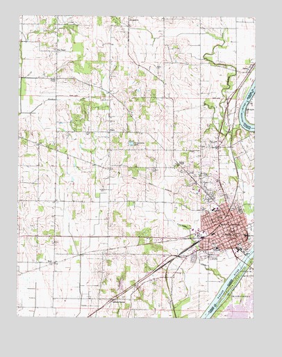
Mount Carmel, IL USGS Topographic Map
Click on map above to begin viewing in our Map Viewer.

This topographic map contains these locations and features:
Feature Name Type Latitude Longitude GNIS ID View Map
Abundant Life New Life Fellowship ChurchChurchN38.4081°W87.7564°1823650View Map
Asbury ChapelChurchN38.4389°W87.7909°403650View Map
Beauchamp and Harper CemeteryCemeteryN38.4423°W87.7786°2045762View Map
Beckerman FieldAirportN38.4074°W87.8408°427577View Map
Burnet PondLakeN38.3791°W87.7631°431847View Map
Chapman CemeteryCemeteryN38.4362°W87.8042°405971View Map
Cherry Hill EstatesPopulated PlaceN38.4289°W87.7628°1823655View Map
Church of the NazareneChurchN38.4128°W87.7656°1823656View Map
City of Mount CarmelCivilN38.4189°W87.7694°2395120View Map
Conservation LakeReservoirN38.4472°W87.8151°406486View Map
Crawfish CreekStreamN38.4556°W87.7578°406753View Map
Emmanuel Baptist ChurchChurchN38.4178°W87.7661°1823658View Map
First Baptist ChurchChurchN38.4117°W87.7639°1823659View Map
First Christian ChurchChurchN38.4150°W87.7639°1823660View Map
First Presbyterian ChurchChurchN38.4123°W87.7611°1823661View Map
Free Methodist ChurchChurchN38.4078°W87.7681°1823662View Map
Friends Grove Post Office (historical)Post OfficeN38.4228°W87.8464°1823663View Map
General Baptist Nursing HomeHospitalN38.4117°W87.7795°1823664View Map
Gospel Kingdom ChurchChurchN38.4123°W87.7589°1823665View Map
Greathouse CreekStreamN38.3900°W87.7648°409366View Map
Hallock CemeteryCemeteryN38.4525°W87.8384°409669View Map
Harper CemeteryCemeteryN38.4278°W87.8295°409822View Map
Highland Memorial CemeteryCemeteryN38.4275°W87.7734°1823666View Map
Lingenfelter CemeteryCemeteryN38.4423°W87.7784°2045836View Map
MaudPopulated PlaceN38.3975°W87.8553°413134View Map
Mount CarmelPopulated PlaceN38.4109°W87.7614°413939View Map
Mount Carmel City BuildingBuildingN38.4081°W87.7598°1725692View Map
Mount Carmel Election PrecinctCivilN38.4200°W87.8015°1928577View Map
Mount Carmel Fire DepartmentBuildingN38.4142°W87.7680°2682059View Map
Mount Carmel High SchoolSchoolN38.4095°W87.7545°1823669View Map
Mount Carmel Post OfficePost OfficeN38.4112°W87.7615°1725693View Map
Mount Carmel Public LibraryBuildingN38.4150°W87.7620°1823670View Map
Mount Carmel Water Treatment PlantLocaleN38.4064°W87.7550°2741004View Map
Nisbet ChapelChurchN38.4737°W87.8556°414535View Map
North Middle SchoolSchoolN38.4203°W87.7714°414658View Map
Nye Chapel United Methodist ChurchChurchN38.4856°W87.8559°414740View Map
Nyle Chapel CemeteryCemeteryN38.4856°W87.8559°2045816View Map
OdgenPopulated PlaceN38.4520°W87.8270°423032View Map
Patoka IslandIslandN38.3892°W87.7600°440923View Map
Patoka RiverStreamN38.4006°W87.7503°451316View Map
PattonPopulated PlaceN38.4770°W87.7536°415449View Map
Pentecostal Assembly of God ChurchChurchN38.4053°W87.7614°1823674View Map
Potters Field CemeteryCemeteryN38.4464°W87.7781°2045777View Map
Rose Hill CemeteryCemeteryN38.4198°W87.7575°416942View Map
Saint John the Baptist Episcopal ChurchChurchN38.4131°W87.7606°1823672View Map
Saint Marys Catholic ChurchChurchN38.4100°W87.7628°1823673View Map
Saint Marys CemeteryCemeteryN38.4195°W87.7770°417553View Map
Saint Marys SchoolSchoolN38.4095°W87.7623°417604View Map
Sand Hill CemeteryCemeteryN38.4050°W87.7703°417939View Map
Schrodts StationPopulated PlaceN38.3825°W87.8250°418111View Map
South Elementary SchoolSchoolN38.4042°W87.7695°418826View Map
Trinity United Methodist ChurchChurchN38.4117°W87.7606°1823677View Map
Wabash CountyCivilN38.4461°W87.8443°424293View Map
Wabash County CourthouseBuildingN38.4098°W87.7606°1725694View Map
Wabash County Sheriff's OfficeBuildingN38.4099°W87.7608°2758999View Map
Wabash General HospitalHospitalN38.4206°W87.7695°1823678View Map
Wabash General Hospital HeliportAirportN38.4214°W87.7695°427575View Map
Wabash Valley Club Conservation Lake DamDamN38.4464°W87.8156°1691434View Map
Wabash Valley CollegeSchoolN38.4292°W87.7814°1823679View Map
White RiverPopulated PlaceN38.3942°W87.7531°445956View Map
Woods Family CemeteryCemeteryN38.4789°W87.8028°421473View Map
WRBT-FM (Mount Carmel)TowerN38.3992°W87.7884°428518View Map
WVJC-FM (Mount Carmel)TowerN38.4414°W87.7573°428519View Map
WYER-AM (Mount Carmel)TowerN38.4495°W87.7700°428438View Map
Zion Evangelical Lutheran ChurchChurchN38.4137°W87.7631°1823680View Map

Note: Coordinates in the location and feature list above are referenced to NAD83 datum.


Copyright (C) 2008-2025 Ryan Niemi / Sunset Dynamics ... All Rights Reserved