TopoQuest Logo
Do you find TopoQuest useful?
Help keep TopoQuest running and adding new maps/features by donating!
Bitcoin:  19c7KJd3qBynnjoSw5npx9KScwjBe4ifkT
Litecoin:  LXs6TkuXGGXo1vDsWCkWVdjQX94eUKd6ui
Home View Maps Find Maps Find Places Resources & Links


Keensburg, Illinois Topographic Map

USGS Map Title: Keensburg, IL
USGS Map MRC: 38087C7
DRG (GeoTIFF) Download: o38087c7.tif


Neighboring USGS Topographic Map Quads:


  Bone Gap, IL  
38087D8
 

  Mount Carmel, IL  
38087D7
 

  East Mount Carmel, IN  
38087D6
 

  Grayville, IL  
38087C8
 

  Keensburg, IL  
38087C7
 

  Owensville, IN  
38087C6
 

  New Harmony, IN  
38087B8
 

  Poseyville, IN  
38087B7
 

  Cynthiana, IN  
38087B6


Map MRC Location:

N39°
W88°
N39°
W87°
H8 H7 H6 H5 H4 H3 H2 H1
G8 G7 G6 G5 G4 G3 G2 G1
F8 F7 F6 F5 F4 F3 F2 F1
E8 E7 E6 E5 E4 E3 E2 E1
D8 D7 D6 D5 D4 D3 D2 D1
C8 C7 C6 C5 C4 C3 C2 C1
B8 B7 B6 B5 B4 B3 B2 B1
A8 A7 A6 A5 A4 A3 A2 A1
N38°
W88°
N38°
W87°

Keensburg, IL USGS 1:24K Topographic Map Preview:
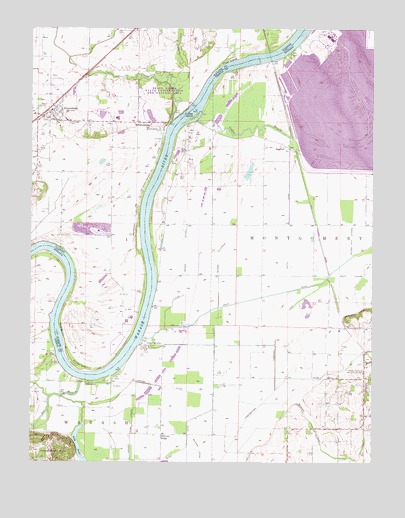
Keensburg, IL USGS Topographic Map
Click on map above to begin viewing in our Map Viewer.

This topographic map contains these locations and features:
Feature Name Type Latitude Longitude GNIS ID View Map
Barren CreekStreamN38.2670°W87.7895°430526View Map
Beall WoodsWoodsN38.3587°W87.8250°1823653View Map
Beall Woods Nature PreserveParkN38.3589°W87.8228°1993504View Map
Beall Woods State Conservation and Natural AreaParkN38.3550°W87.8273°1725691View Map
Belcher DitchCanalN38.2537°W87.8125°430751View Map
Blood DitchCanalN38.2537°W87.8186°431195View Map
Brewer Hill CemeteryCemeteryN38.3475°W87.8461°2045767View Map
Broad PondReservoirN38.3507°W87.7578°431541View Map
Coffee BayouStreamN38.3484°W87.8139°432731View Map
Coffee CemeteryCemeteryN38.3480°W87.8587°406324View Map
Coffee CreekStreamN38.3481°W87.8236°406325View Map
Coffee Election PrecinctCivilN38.3350°W87.8604°1928465View Map
Coffee IslandIslandN38.3495°W87.8148°432736View Map
CrawleyvillePopulated PlaceN38.2834°W87.8334°433104View Map
Duck IslandIslandN38.3659°W87.8028°407453View Map
Foote PondLakeN38.2529°W87.8562°434633View Map
Foote Pond HillsRangeN38.2531°W87.8675°434634View Map
Franks DitchCanalN38.2531°W87.8675°434786View Map
Gibson Generating StationBuildingN38.3725°W87.7658°2129715View Map
Gibson Public Service Generation Plant DamDamN38.3500°W87.7500°447826View Map
Hickory RidgePopulated PlaceN38.2584°W87.8267°436111View Map
Hickory Ridge LateralCanalN38.2581°W87.8381°436114View Map
Higginbotham DitchCanalN38.2959°W87.7836°436132View Map
JimtownPopulated PlaceN38.2731°W87.8531°437010View Map
Johnson DitchCanalN38.2717°W87.8242°437048View Map
Johnson DrainStreamN38.2814°W87.7520°437058View Map
Keens CemeteryCemeteryN38.3523°W87.8720°411347View Map
KeensburgPopulated PlaceN38.3506°W87.8686°411348View Map
Keensburg Bealls Woods Volunteer Fire DepartmentBuildingN38.3509°W87.8687°2682632View Map
Keniepe LateralCanalN38.3103°W87.8061°437240View Map
Le Gier-Lovellette CemeteryCemeteryN38.3475°W87.8320°411881View Map
Little Sumner DitchCanalN38.3142°W87.8175°438157View Map
Maumee ChurchChurchN38.2787°W87.7523°438740View Map
Purdue University Horticultural FarmSchoolN38.2767°W87.7517°441660View Map
RochesterPopulated PlaceN38.3456°W87.8281°416784View Map
Rochester and McCleary Bluffs LeveeLeveeN38.2881°W87.8381°416786View Map
Scott DitchCanalN38.3078°W87.7595°443147View Map
Scott LateralCanalN38.3039°W87.7570°443152View Map
SkeltonPopulated PlaceN38.3414°W87.7817°443570View Map
Sugar CreekStreamN38.3573°W87.8214°419273View Map
Thompson DitchCanalN38.2873°W87.7853°444708View Map
Village of KeensburgCivilN38.3517°W87.8683°2398332View Map
Watts DitchCanalN38.3209°W87.7798°445561View Map

Note: Coordinates in the location and feature list above are referenced to NAD83 datum.


Copyright (C) 2008-2024 Ryan Niemi / Sunset Dynamics ... All Rights Reserved