TopoQuest Logo
Do you find TopoQuest useful?
Help keep TopoQuest running and adding new maps/features by donating!
Bitcoin:  19c7KJd3qBynnjoSw5npx9KScwjBe4ifkT
Litecoin:  LXs6TkuXGGXo1vDsWCkWVdjQX94eUKd6ui
Home View Maps Find Maps Find Places Resources & Links


Eastman, Georgia Topographic Map

USGS Map Title: Eastman, GA
USGS Map MRC: 32083B2
DRG (GeoTIFF) Download: o32083b2.tif


Neighboring USGS Topographic Map Quads:


  Empire, GA  
32083C3
 

  Yonkers, GA  
32083C2
 

  Cadwell, GA  
32083C1
 

  West of Eastman, GA  
32083B3
 

  Eastman, GA  
32083B2
 

  Jay Bird Springs, GA  
32083B1
 

  Abbeville North, GA  
32083A3
 

  Lake Cypress, GA  
32083A2
 

  Milan, GA  
32083A1


Map MRC Location:

N33°
W84°
N33°
W83°
H8 H7 H6 H5 H4 H3 H2 H1
G8 G7 G6 G5 G4 G3 G2 G1
F8 F7 F6 F5 F4 F3 F2 F1
E8 E7 E6 E5 E4 E3 E2 E1
D8 D7 D6 D5 D4 D3 D2 D1
C8 C7 C6 C5 C4 C3 C2 C1
B8 B7 B6 B5 B4 B3 B2 B1
A8 A7 A6 A5 A4 A3 A2 A1
N32°
W84°
N32°
W83°

Eastman, GA USGS 1:24K Topographic Map Preview:
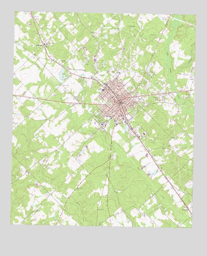
Eastman, GA USGS Topographic Map
Click on map above to begin viewing in our Map Viewer.

This topographic map contains these locations and features:
Feature Name Type Latitude Longitude GNIS ID View Map
Amoskeag (historical)Populated PlaceN32.1696°W83.1560°348103View Map
City of EastmanCivilN32.1974°W83.1715°2403536View Map
Crooked BranchStreamN32.2363°W83.1457°313127View Map
DempseyPopulated PlaceN32.2466°W83.2374°348114View Map
Dempsey ChurchChurchN32.2471°W83.2374°313439View Map
Dodge CountyCivilN32.1722°W83.1684°348116View Map
Dodge County High SchoolSchoolN32.2049°W83.1879°348117View Map
Dodge County HospitalHospitalN32.1856°W83.1779°348118View Map
Dodge County JailBuildingN32.2016°W83.1736°2734208View Map
Dodge County Sheriff's DepartmentBuildingN32.2015°W83.1736°2733824View Map
Dodge Elementary SchoolSchoolN32.2310°W83.2290°348119View Map
Dodge HighPopulated PlaceN32.2304°W83.2290°313517View Map
Dodge Plaza Shopping CenterLocaleN32.1910°W83.1735°348120View Map
EastmanPopulated PlaceN32.1977°W83.1777°355610View Map
Eastman DivisionCivilN32.2288°W83.1891°1936239View Map
Eastman Elementary SchoolSchoolN32.1899°W83.1743°348123View Map
Eastman Fire Department Station 1BuildingN32.2027°W83.1789°2604660View Map
Eastman Fire Department Station 2BuildingN32.1961°W83.1753°2603821View Map
Eastman Methodist ChurchChurchN32.1996°W83.1757°348124View Map
Eastman Middle SchoolSchoolN32.1846°W83.1882°348125View Map
Eastman Police DepartmentBuildingN32.1958°W83.1756°2733875View Map
Eastman Regional Youth Detention CenterBuildingN32.1809°W83.1598°2735691View Map
Eastman Youth Development CampusBuildingN32.1793°W83.1525°2735749View Map
Evans CemeteryCemeteryN32.2199°W83.1968°313992View Map
First Baptist Church of EastmanChurchN32.1980°W83.1799°348126View Map
GodwinsvillePopulated PlaceN32.1357°W83.1271°326303View Map
Greenlawn CemeteryCemeteryN32.2024°W83.1501°314864View Map
Harrell CemeteryCemeteryN32.2241°W83.2343°315172View Map
Harrell PondReservoirN32.1826°W83.1710°341198View Map
Harrell Pond DamDamN32.1818°W83.1699°341197View Map
Heart of Georgia Regional AirportAirportN32.2135°W83.1263°326809View Map
Jamieson PondReservoirN32.1568°W83.1532°336249View Map
Jamieson Pond DamDamN32.1568°W83.1532°336248View Map
Lockett CemeteryCemeteryN32.2418°W83.2288°317272View Map
Love All ChurchChurchN32.1349°W83.1896°317436View Map
LoweryPopulated PlaceN32.2057°W83.1279°348131View Map
Orphans CemeteryCemeteryN32.2074°W83.2160°320097View Map
Parkerson Gift ChurchChurchN32.1716°W83.1463°320235View Map
Piney Grove ChurchChurchN32.1468°W83.2049°320708View Map
Pleasant Hill ChurchChurchN32.2379°W83.1946°320881View Map
Saint Marks ChurchChurchN32.2024°W83.1276°322178View Map
Sheffield BranchStreamN32.2157°W83.1396°322820View Map
Tripps LakeReservoirN32.2096°W83.2165°336245View Map
Tripps Lake DamDamN32.2102°W83.2165°336244View Map
WUFF-AM (Eastman)TowerN32.2266°W83.2193°352439View Map
WUFF-FM (Eastman)TowerN32.2266°W83.2193°352683View Map
Zebulon ChurchChurchN32.2174°W83.2124°325656View Map

Note: Coordinates in the location and feature list above are referenced to NAD83 datum.


Copyright (C) 2008-2025 Ryan Niemi / Sunset Dynamics ... All Rights Reserved