TopoQuest Logo
Do you find TopoQuest useful?
Help keep TopoQuest running and adding new maps/features by donating!
Bitcoin:  19c7KJd3qBynnjoSw5npx9KScwjBe4ifkT
Litecoin:  LXs6TkuXGGXo1vDsWCkWVdjQX94eUKd6ui
Home View Maps Find Maps Find Places Resources & Links


Ellsinore, Missouri Topographic Map

USGS Map Title: Ellsinore, MO
USGS Map MRC: 36090H6
DRG (GeoTIFF) Download: o36090h6.tif


Neighboring USGS Topographic Map Quads:


  Ellington SE, MO  
37090A7
 

  Mill Spring, MO  
37090A6
 

  Piedmont SE, MO  
37090A5
 

  Hunter, MO  
36090H7
 

  Ellsinore, MO  
36090H6
 

  Williamsville, MO  
36090H5
 

  Grandin, MO  
36090G7
 

  Hogan Hollow, MO  
36090G6
 

  Stringtown, MO  
36090G5


Map MRC Location:

N37°
W91°
N37°
W90°
H8 H7 H6 H5 H4 H3 H2 H1
G8 G7 G6 G5 G4 G3 G2 G1
F8 F7 F6 F5 F4 F3 F2 F1
E8 E7 E6 E5 E4 E3 E2 E1
D8 D7 D6 D5 D4 D3 D2 D1
C8 C7 C6 C5 C4 C3 C2 C1
B8 B7 B6 B5 B4 B3 B2 B1
A8 A7 A6 A5 A4 A3 A2 A1
N36°
W91°
N36°
W90°

Ellsinore, MO USGS 1:24K Topographic Map Preview:
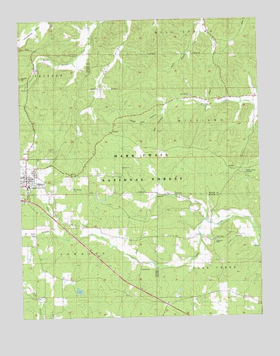
Ellsinore, MO USGS Topographic Map
Click on map above to begin viewing in our Map Viewer.

This topographic map contains these locations and features:
Feature Name Type Latitude Longitude GNIS ID View Map
Brush ArborPopulated PlaceN36.9076°W90.6482°749055View Map
Brush Arbor Community CenterBuildingN36.9064°W90.6487°753661View Map
CCC Camp (historical)LocaleN36.9451°W90.7343°753472View Map
Chapel Hill ChurchChurchN36.9684°W90.6615°753657View Map
Chapel Hill School (historical)SchoolN36.9662°W90.6671°749329View Map
City of EllsinoreCivilN36.9328°W90.7477°2394665View Map
Commertown SchoolSchoolN36.9859°W90.7187°754395View Map
Condroys LakeReservoirN36.8863°W90.7203°764097View Map
Crommertown School (historical)SchoolN36.9856°W90.7179°749524View Map
EllsinorePopulated PlaceN36.9342°W90.7468°749825View Map
Ellsinore Police DepartmentBuildingN36.9331°W90.7481°2752375View Map
Ellsinore Post OfficePost OfficeN36.9342°W90.7469°2783208View Map
Ellsinore Rural Fire Protection DistrictBuildingN36.9307°W90.7468°2620767View Map
Freeland School (historical)SchoolN36.9126°W90.7085°749991View Map
Harmony CemeteryCemeteryN36.9377°W90.6973°2681409View Map
Harmony General Baptist ChurchChurchN36.9379°W90.6966°748667View Map
Hill TopLocaleN36.9345°W90.7235°750328View Map
Hill Top CemeteryCemeteryN36.9292°W90.7232°753658View Map
Hilladay (historical)LocaleN36.9617°W90.6821°740367View Map
Kearney CemeteryCemeteryN36.8950°W90.6876°750561View Map
King HollowValleyN36.9092°W90.6290°750612View Map
Lakeview Tree Farm DamDamN36.8851°W90.7185°764096View Map
North Fork HollowValleyN36.9164°W90.6532°751341View Map
Orchard SwitchLocaleN36.9523°W90.7026°751444View Map
PondLocaleN36.9453°W90.6593°740100View Map
Robertson CemeteryCemeteryN36.9753°W90.7482°753655View Map
Seed Tick HollowValleyN36.9626°W90.6726°752072View Map
South Fork HollowValleyN36.9120°W90.7346°752258View Map
Union Hill ChurchChurchN36.9853°W90.7196°753656View Map
UpalikaPopulated PlaceN36.9367°W90.6393°752673View Map
Upalika PondReservoirN36.9358°W90.6326°753659View Map
Walton ChapelChurchN36.9078°W90.6482°753660View Map
Walton School (historical)SchoolN36.9081°W90.6551°752752View Map
Wet HollowValleyN36.9603°W90.6737°752836View Map

Note: Coordinates in the location and feature list above are referenced to NAD83 datum.


Copyright (C) 2008-2025 Ryan Niemi / Sunset Dynamics ... All Rights Reserved