TopoQuest Logo
Do you find TopoQuest useful?
Help keep TopoQuest running and adding new maps/features by donating!
Bitcoin:  19c7KJd3qBynnjoSw5npx9KScwjBe4ifkT
Litecoin:  LXs6TkuXGGXo1vDsWCkWVdjQX94eUKd6ui
Home View Maps Find Maps Find Places Resources & Links


Hunter, Missouri Topographic Map

USGS Map Title: Hunter, MO
USGS Map MRC: 36090H7
DRG (GeoTIFF) Download: o36090h7.tif


Neighboring USGS Topographic Map Quads:


  Garwood, MO  
37090A8
 

  Ellington SE, MO  
37090A7
 

  Mill Spring, MO  
37090A6
 

  Big Spring, MO  
36090H8
 

  Hunter, MO  
36090H7
 

  Ellsinore, MO  
36090H6
 

  Grandin SW, MO  
36090G8
 

  Grandin, MO  
36090G7
 

  Hogan Hollow, MO  
36090G6


Map MRC Location:

N37°
W91°
N37°
W90°
H8 H7 H6 H5 H4 H3 H2 H1
G8 G7 G6 G5 G4 G3 G2 G1
F8 F7 F6 F5 F4 F3 F2 F1
E8 E7 E6 E5 E4 E3 E2 E1
D8 D7 D6 D5 D4 D3 D2 D1
C8 C7 C6 C5 C4 C3 C2 C1
B8 B7 B6 B5 B4 B3 B2 B1
A8 A7 A6 A5 A4 A3 A2 A1
N36°
W91°
N36°
W90°

Hunter, MO USGS 1:24K Topographic Map Preview:
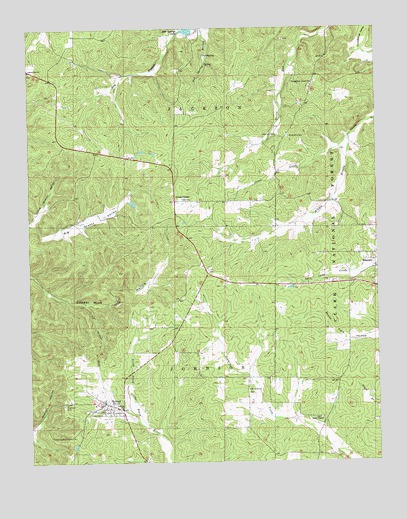
Hunter, MO USGS Topographic Map
Click on map above to begin viewing in our Map Viewer.

This topographic map contains these locations and features:
Feature Name Type Latitude Longitude GNIS ID View Map
Carnahan Lake DamDamN36.9484°W90.8168°763722View Map
Community ChurchChurchN36.9881°W90.8746°749436View Map
Crites CornerPopulated PlaceN36.9503°W90.8226°749521View Map
Crites CreekStreamN36.9687°W90.7598°749522View Map
Elm Springs LakeReservoirN36.9991°W90.8176°758278View Map
Elm Springs Lake DamDamN36.9984°W90.8151°763595View Map
Evangelistic Center ChurchChurchN36.9842°W90.7726°749860View Map
Grandin Junction (historical)LocaleN36.9234°W90.8001°740419View Map
Highland CemeteryCemeteryN36.8914°W90.8632°750320View Map
HunterPopulated PlaceN36.8906°W90.8490°750422View Map
Hunter Census Designated PlaceCensusN36.8867°W90.8483°2587080View Map
Hunter Lookout TowerTowerN36.8826°W90.8607°755223View Map
Junction Switch (historical)LocaleN36.9214°W90.7890°740418View Map
Little Grassy ValleyValleyN36.9448°W90.8743°750770View Map
Mount Carmel ChurchChurchN36.8959°W90.7971°751171View Map
Number 445 DamDamN36.9251°W90.7801°764438View Map
Oak SpringSpringN36.9924°W90.8120°751396View Map
Pine Woods DamDamN36.9167°W90.7701°765330View Map
Pinewoods LakeLakeN36.9179°W90.7734°754397View Map
Pinewoods LakeLocaleN36.9220°W90.7748°754398View Map
Pinewoods Lake CampgroundLocaleN36.9192°W90.7729°753980View Map
Raymers CemeteryCemeteryN36.9692°W90.7859°751818View Map
Rozark Incorporated ReservoirReservoirN36.9468°W90.8185°763723View Map
Smith ChapelChurchN36.8873°W90.7707°752213View Map
Smith Chapel CemeteryCemeteryN36.8876°W90.7710°2681411View Map
Township of JacksonCivilN36.9944°W90.8050°766427View Map
Township of JohnsonCivilN36.8757°W90.7841°766428View Map
Upper Tenmile School (historical)SchoolN36.8995°W90.7921°747654View Map
Wallace LakeReservoirN36.9332°W90.7610°765063View Map
Wallace Lake DamDamN36.9334°W90.7601°765062View Map
White Mill CemeteryCemeteryN36.9689°W90.7815°752854View Map
White Mill SchoolSchoolN36.9695°W90.7821°747653View Map

Note: Coordinates in the location and feature list above are referenced to NAD83 datum.


Copyright (C) 2008-2025 Ryan Niemi / Sunset Dynamics ... All Rights Reserved