TopoQuest Logo
Do you find TopoQuest useful?
Help keep TopoQuest running and adding new maps/features by donating!
Bitcoin:  19c7KJd3qBynnjoSw5npx9KScwjBe4ifkT
Litecoin:  LXs6TkuXGGXo1vDsWCkWVdjQX94eUKd6ui
Home View Maps Find Maps Find Places Resources & Links


Emory South, Texas Topographic Map

USGS Map Title: Emory South, TX
USGS Map MRC: 32095G7
DRG (GeoTIFF) Download: o32095g7.tif


Neighboring USGS Topographic Map Quads:


  Lone Oak South, TX  
32095H8
 

  Emory North, TX  
32095H7
 

  Arbala, TX  
32095H6
 

  Iron Bridge Dam, TX  
32095G8
 

  Emory South, TX  
32095G7
 

  Alba, TX  
32095G6
 

  Edgewood, TX  
32095F8
 

  Fruitvale, TX  
32095F7
 

  Grand Saline, TX  
32095F6


Map MRC Location:

N33°
W96°
N33°
W95°
H8 H7 H6 H5 H4 H3 H2 H1
G8 G7 G6 G5 G4 G3 G2 G1
F8 F7 F6 F5 F4 F3 F2 F1
E8 E7 E6 E5 E4 E3 E2 E1
D8 D7 D6 D5 D4 D3 D2 D1
C8 C7 C6 C5 C4 C3 C2 C1
B8 B7 B6 B5 B4 B3 B2 B1
A8 A7 A6 A5 A4 A3 A2 A1
N32°
W96°
N32°
W95°

Emory South, TX USGS 1:24K Topographic Map Preview:
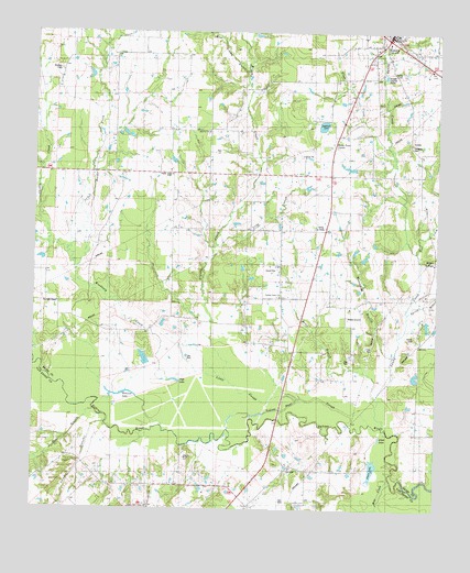
Emory South, TX USGS Topographic Map
Click on map above to begin viewing in our Map Viewer.

This topographic map contains these locations and features:
Feature Name Type Latitude Longitude GNIS ID View Map
A C McMilllan African American MuseumBuildingN32.8732°W95.7666°2014478View Map
Allread CreekStreamN32.7607°W95.7502°1372280View Map
Bear CreekStreamN32.8179°W95.7566°1372439View Map
Bee BranchStreamN32.7760°W95.8561°1372473View Map
Brushy CreekStreamN32.7840°W95.8152°1372771View Map
Campbell CemeteryCemeteryN32.8459°W95.7582°1372898View Map
Clewis CemeteryCemeteryN32.7954°W95.7572°1373139View Map
Danley CemeteryCemeteryN32.8640°W95.7627°1373340View Map
Ditch LakeLakeN32.7690°W95.7674°1373406View Map
DunbarPopulated PlaceN32.8060°W95.7994°2034701View Map
Dunbar Union ChurchChurchN32.8060°W95.7997°1889940View Map
EmoryPopulated PlaceN32.8746°W95.7655°1373660View Map
Fish LakeLakeN32.7841°W95.8317°1373722View Map
Glade CreekStreamN32.8404°W95.7630°1373845View Map
Henderson County Clint W Murchison Memorial LibraryBuildingN32.8360°W95.8552°2014980View Map
Highland LakeLakeN32.8509°W95.7860°1374067View Map
Holcomb LakeLakeN32.7800°W95.8483°1374100View Map
Holcomb SloughGutN32.7790°W95.8525°1374101View Map
Lake ChurchLakeN32.7504°W95.8080°1373105View Map
Little SloughStreamN32.7793°W95.7930°1374609View Map
Long BranchStreamN32.8193°W95.8183°1374690View Map
Martin BluffCliffN32.7643°W95.8286°1374806View Map
Mill CreekStreamN32.7579°W95.7641°1374950View Map
Muscadine BranchStreamN32.7904°W95.7639°1375076View Map
Ocean LakeLakeN32.7609°W95.7697°1375258View Map
Rains CountyCivilN32.8703°W95.7934°1383975View Map
Reeder CreekStreamN32.8132°W95.8627°1375690View Map
Rockey Point CenterBuildingN32.8460°W95.7827°1889939View Map
Rocky Point CemeteryCemeteryN32.8454°W95.7839°1375811View Map
Rocky Point CenterPopulated PlaceN32.8460°W95.7836°1877615View Map
Sandy CreekStreamN32.7721°W95.7664°1376009View Map
Shuffle CreekStreamN32.8132°W95.8627°1376114View Map
SmyrnaPopulated PlaceN32.8490°W95.8219°2034768View Map
Smyrna Church CemeteryCemeteryN32.8482°W95.8219°1376162View Map
Spring BranchStreamN32.8018°W95.7591°1376259View Map
Stewart BranchStreamN32.7726°W95.8527°1376304View Map
Trumble CemeteryCemeteryN32.8040°W95.8680°1376511View Map
West Brushy BranchStreamN32.8651°W95.8100°1372216View Map
Willow SpringsPopulated PlaceN32.8165°W95.7508°1380940View Map
Woodbury CreekStreamN32.7837°W95.8327°1376859View Map
Woosley CemeteryCemeteryN32.8648°W95.8677°1376873View Map
Yellow Steer SloughGutN32.7779°W95.7941°1376889View Map

Note: Coordinates in the location and feature list above are referenced to NAD83 datum.


Copyright (C) 2008-2024 Ryan Niemi / Sunset Dynamics ... All Rights Reserved