TopoQuest Logo
Do you find TopoQuest useful?
Help keep TopoQuest running and adding new maps/features by donating!
Bitcoin:  19c7KJd3qBynnjoSw5npx9KScwjBe4ifkT
Litecoin:  LXs6TkuXGGXo1vDsWCkWVdjQX94eUKd6ui
Home View Maps Find Maps Find Places Resources & Links


Iron Bridge Dam, Texas Topographic Map

USGS Map Title: Iron Bridge Dam, TX
USGS Map MRC: 32095G8
DRG (GeoTIFF) Download: o32095g8.tif


Neighboring USGS Topographic Map Quads:


  West Tawakoni, TX  
32096H1
 

  Lone Oak South, TX  
32095H8
 

  Emory North, TX  
32095H7
 

  Ables Springs, TX  
32096G1
 

  Iron Bridge Dam, TX  
32095G8
 

  Emory South, TX  
32095G7
 

  Wills Point, TX  
32096F1
 

  Edgewood, TX  
32095F8
 

  Fruitvale, TX  
32095F7


Map MRC Location:

N33°
W96°
N33°
W95°
H8 H7 H6 H5 H4 H3 H2 H1
G8 G7 G6 G5 G4 G3 G2 G1
F8 F7 F6 F5 F4 F3 F2 F1
E8 E7 E6 E5 E4 E3 E2 E1
D8 D7 D6 D5 D4 D3 D2 D1
C8 C7 C6 C5 C4 C3 C2 C1
B8 B7 B6 B5 B4 B3 B2 B1
A8 A7 A6 A5 A4 A3 A2 A1
N32°
W96°
N32°
W95°

Iron Bridge Dam, TX USGS 1:24K Topographic Map Preview:
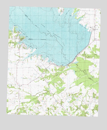
Iron Bridge Dam, TX USGS Topographic Map
Click on map above to begin viewing in our Map Viewer.

This topographic map contains these locations and features:
Feature Name Type Latitude Longitude GNIS ID View Map
Autumn PointCapeN32.8387°W95.9766°1372361View Map
Bright Star CemeteryCemeteryN32.7996°W95.9511°1372719View Map
Bright Star ChurchChurchN32.7987°W95.9525°1372720View Map
Caney CreekStreamN32.8323°W95.9897°1372930View Map
Cedar CreekStreamN32.7746°W95.9366°1373013View Map
Chapel of the LakeChurchN32.8348°W95.9852°1373054View Map
Clarks ChapelChurchN32.8401°W95.8822°1373123View Map
CliftonPopulated PlaceN32.7829°W95.9827°2034729View Map
FlatsPopulated PlaceN32.8385°W95.8827°1380853View Map
Goose LakeLakeN32.7988°W95.9113°1373875View Map
Gum CoveBayN32.8346°W95.9811°1373946View Map
Iron Bridge DamDamN32.8233°W95.9028°1372717View Map
Koen CreekStreamN32.7773°W95.9452°1374398View Map
Lake Tawakoni State ParkParkN32.8487°W96.0000°2028985View Map
Lake Tawakoni State Park TrailTrailN32.8496°W95.9930°2033494View Map
Long Bow ReachChannelN32.8293°W95.9719°1374688View Map
Magby CreekStreamN32.7543°W95.9939°1372178View Map
McBee CreekStreamN32.7893°W95.8800°1374832View Map
McEnturff CreekStreamN32.7876°W95.8783°1374848View Map
Moon PointCapeN32.8657°W95.9152°1374995View Map
Morince CemeteryCemeteryN32.7510°W95.8830°1375004View Map
Rocky Point CemeteryCemeteryN32.7507°W95.9872°1877616View Map
Shook CemeteryCemeteryN32.8726°W95.9258°1376112View Map
Southwest Rains Volunteer Fire DepartmentBuildingN32.8289°W95.8942°2655548View Map
Spring PointCapeN32.8515°W95.9886°1376278View Map
Star PointCapeN32.8551°W95.9014°1376289View Map
Sun PointCapeN32.8662°W95.9308°1376339View Map
Tall Man ReachChannelN32.8523°W95.8972°1376373View Map
Van Zandt County ParkParkN32.8079°W95.9277°1376573View Map
Warloup ReachChannelN32.8173°W95.9452°1376645View Map
White Deer ReachChannelN32.8460°W95.9825°1376746View Map
Wills CreekStreamN32.7690°W95.9614°1376828View Map
Wolf CoveBayN32.8196°W95.9689°1376845View Map
Wolf CreekStreamN32.8132°W95.9791°1376853View Map

Note: Coordinates in the location and feature list above are referenced to NAD83 datum.


Copyright (C) 2008-2024 Ryan Niemi / Sunset Dynamics ... All Rights Reserved