TopoQuest Logo
Do you find TopoQuest useful?
Help keep TopoQuest running and adding new maps/features by donating!
Bitcoin:  19c7KJd3qBynnjoSw5npx9KScwjBe4ifkT
Litecoin:  LXs6TkuXGGXo1vDsWCkWVdjQX94eUKd6ui
Home View Maps Find Maps Find Places Resources & Links


Extension, Louisiana Topographic Map

USGS Map Title: Extension, LA
USGS Map MRC: 31091H7
DRG (GeoTIFF) Download: o31091h7.tif


Neighboring USGS Topographic Map Quads:


  Mason, LA  
32091A8
 

  Fort Necessity, LA  
32091A7
 

  Gilbert, LA  
32091A6
 

  Enterprise, LA  
31091H8
 

  Extension, LA  
31091H7
 

  Wisner, LA  
31091H6
 

  Aimwell, LA  
31091G8
 

  Harrisonburg, LA  
31091G7
 

  Sicily Island, LA  
31091G6


Map MRC Location:

N32°
W92°
N32°
W91°
H8 H7 H6 H5 H4 H3 H2 H1
G8 G7 G6 G5 G4 G3 G2 G1
F8 F7 F6 F5 F4 F3 F2 F1
E8 E7 E6 E5 E4 E3 E2 E1
D8 D7 D6 D5 D4 D3 D2 D1
C8 C7 C6 C5 C4 C3 C2 C1
B8 B7 B6 B5 B4 B3 B2 B1
A8 A7 A6 A5 A4 A3 A2 A1
N31°
W92°
N31°
W91°

Extension, LA USGS 1:24K Topographic Map Preview:
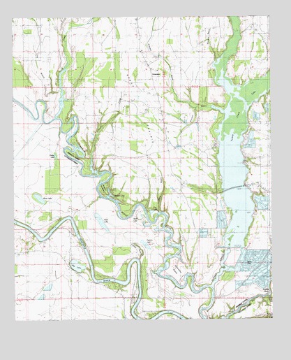
Extension, LA USGS Topographic Map
Click on map above to begin viewing in our Map Viewer.

This topographic map contains these locations and features:
Feature Name Type Latitude Longitude GNIS ID View Map
Barnett LakeLakeN31.9268°W91.8507°553351View Map
Big BrakeReservoirN31.9004°W91.7689°553632View Map
Big LakeLakeN31.8978°W91.8446°553650View Map
Boeuf PrairieFlatN31.9654°W91.8132°533260View Map
Brush LakeLakeN31.9256°W91.8627°553799View Map
Brushey BayouStreamN31.8852°W91.7518°533452View Map
Carrway CemeteryCemeteryN31.9465°W91.7862°553905View Map
Cocklebur IslandIslandN31.8943°W91.7965°534016View Map
Cutoff BayouStreamN31.9004°W91.8146°534321View Map
Cypress LakeLakeN31.9062°W91.8115°554174View Map
Dailey LakeLakeN31.9433°W91.8550°554178View Map
Dry LakeLakeN31.9193°W91.8073°554275View Map
Duck CreekStreamN31.9354°W91.8343°534634View Map
ExtensionPopulated PlaceN31.9707°W91.8060°543195View Map
Flowers BayouStreamN31.9824°W91.7754°535014View Map
Fool RiverStreamN31.9468°W91.8454°554449View Map
Goose CreekStreamN31.9590°W91.8543°535283View Map
Grayson BayouGutN31.9710°W91.7976°554607View Map
Guice LakeLakeN31.8984°W91.7627°554628View Map
Hicktom LakeLakeN31.9271°W91.8284°554707View Map
Jones LandingPopulated PlaceN31.8827°W91.7785°541116View Map
King CemeteryCemeteryN31.9396°W91.7626°536198View Map
King ChurchChurchN31.9302°W91.7562°536200View Map
Locust Hill Baptist ChurchChurchN31.9540°W91.8021°555121View Map
Long BranchStreamN31.9713°W91.8526°536688View Map
Open LakeLakeN31.9124°W91.8171°537885View Map
Ouachita ChurchChurchN31.9077°W91.8601°537908View Map
Prickett BayouGutN31.9627°W91.7840°538401View Map
Rabbit IslandIslandN31.9282°W91.8326°538465View Map
Rock LakeLakeN31.9160°W91.8331°555820View Map
Shady Grove Baptist ChurchChurchN31.9963°W91.7582°556010View Map
Shady Grove CemeteryCemeteryN31.9963°W91.7587°544100View Map
Shop BayouGutN31.9285°W91.8026°539350View Map
Sunk LakeLakeN31.9177°W91.8140°556169View Map
Turkey CreekStreamN31.8888°W91.7790°540033View Map
Turkey Creek DamDamN31.9052°W91.7718°556731View Map
Turkey Creek Lake Airport (historical)AirportN31.9068°W91.7593°1633016View Map
Ward NineCivilN31.9821°W91.8110°545034View Map
West Turkey CreekStreamN31.9690°W91.7676°540335View Map

Note: Coordinates in the location and feature list above are referenced to NAD83 datum.


Copyright (C) 2008-2025 Ryan Niemi / Sunset Dynamics ... All Rights Reserved