TopoQuest Logo
Do you find TopoQuest useful?
Help keep TopoQuest running and adding new maps/features by donating!
Bitcoin:  19c7KJd3qBynnjoSw5npx9KScwjBe4ifkT
Litecoin:  LXs6TkuXGGXo1vDsWCkWVdjQX94eUKd6ui
Home View Maps Find Maps Find Places Resources & Links


Harrisonburg, Louisiana Topographic Map

USGS Map Title: Harrisonburg, LA
USGS Map MRC: 31091G7
DRG (GeoTIFF) Download: o31091g7.tif


Neighboring USGS Topographic Map Quads:


  Enterprise, LA  
31091H8
 

  Extension, LA  
31091H7
 

  Wisner, LA  
31091H6
 

  Aimwell, LA  
31091G8
 

  Harrisonburg, LA  
31091G7
 

  Sicily Island, LA  
31091G6
 

  Manifest, LA  
31091F8
 

  Jonesville North, LA  
31091F7
 

  Dunbarton, LA  
31091F6


Map MRC Location:

N32°
W92°
N32°
W91°
H8 H7 H6 H5 H4 H3 H2 H1
G8 G7 G6 G5 G4 G3 G2 G1
F8 F7 F6 F5 F4 F3 F2 F1
E8 E7 E6 E5 E4 E3 E2 E1
D8 D7 D6 D5 D4 D3 D2 D1
C8 C7 C6 C5 C4 C3 C2 C1
B8 B7 B6 B5 B4 B3 B2 B1
A8 A7 A6 A5 A4 A3 A2 A1
N31°
W92°
N31°
W91°

Harrisonburg, LA USGS 1:24K Topographic Map Preview:
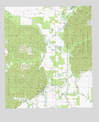
Harrisonburg, LA USGS Topographic Map
Click on map above to begin viewing in our Map Viewer.

This topographic map contains these locations and features:
Feature Name Type Latitude Longitude GNIS ID View Map
Bayou LouisStreamN31.7874°W91.7837°553484View Map
Big BayouGutN31.8704°W91.8454°533020View Map
Big CreekStreamN31.8177°W91.7843°533064View Map
Boeuf RiverStreamN31.8568°W91.7860°76391View Map
Boothe CemeteryCemeteryN31.8215°W91.8221°533329View Map
Brushy CreekStreamN31.7979°W91.8704°533476View Map
Callahan BranchStreamN31.7799°W91.8093°533633View Map
Catahoula Parish CourthouseBuildingN31.7716°W91.8215°546007View Map
Catahoula Parish Sheriff's OfficeBuildingN31.7702°W91.8232°2755248View Map
Coke CreekStreamN31.8649°W91.7790°534027View Map
Deer CreekStreamN31.8741°W91.7765°534460View Map
Dry LakeLakeN31.8232°W91.8085°554274View Map
Gastis CreekStreamN31.8282°W91.8157°535190View Map
Guthrie LakeLakeN31.7682°W91.7812°554634View Map
HarrisonburgPopulated PlaceN31.7721°W91.8215°1629956View Map
Harrisonburg CemeteryCemeteryN31.7677°W91.8282°546018View Map
Harrisonburg Elementary SchoolSchoolN31.7702°W91.8231°546019View Map
Harrisonburg High SchoolSchoolN31.7617°W91.8432°546020View Map
Harrisonburg Oil FieldOilfieldN31.7843°W91.7915°554672View Map
Harrisonburg Police DepartmentBuildingN31.7720°W91.8197°2755300View Map
Harrisonburg Post OfficePost OfficeN31.7706°W91.8207°1630410View Map
Harrisonburg Volunteer Fire DepartmentBuildingN31.7722°W91.8204°2672859View Map
Hooter CreekStreamN31.8641°W91.8635°554746View Map
Kennedy CreekStreamN31.8641°W91.8632°536170View Map
Kidron Baptist ChurchChurchN31.7966°W91.8024°558247View Map
Lake SloughGutN31.8610°W91.8296°536302View Map
Little CreekStreamN31.8146°W91.7818°536527View Map
Lock and Dam Number TwoDamN31.7754°W91.8157°555112View Map
Onemile BayouGutN31.7635°W91.7987°537879View Map
Parish Governing Authority District 4CivilN31.7741°W91.8416°1930005View Map
Prichard Oil FieldOilfieldN31.8613°W91.8746°546048View Map
Rawson CreekStreamN31.8257°W91.7924°538509View Map
Rawson Creek ChurchChurchN31.8296°W91.8143°538510View Map
Rawson Creek Oil FieldOilfieldN31.8474°W91.8276°557082View Map
Sandy BayouGutN31.8666°W91.7601°539147View Map
Sargent LakeLakeN31.7889°W91.7995°555981View Map
Sicily IslandAreaN31.8352°W91.7643°539367View Map
Sicily Island Hills State Wildlife Management AreaParkN31.8321°W91.7598°546060View Map
South Prichard Oil FieldOilfieldN31.7774°W91.8590°546061View Map
Stafford LakeLakeN31.8462°W91.8090°556133View Map
Stafford PointCapeN31.8549°W91.7885°539616View Map
Stafford Point ChurchChurchN31.8702°W91.8004°539617View Map
Stokes Creek Oil FieldOilfieldN31.7635°W91.8640°546064View Map
Straight BayouStreamN31.8616°W91.8393°539686View Map
Town LakeLakeN31.7832°W91.8101°556263View Map
Village of HarrisonburgCivilN31.7680°W91.8251°2407473View Map
Ward FourCivilN31.7677°W91.8104°544975View Map

Note: Coordinates in the location and feature list above are referenced to NAD83 datum.


Copyright (C) 2008-2025 Ryan Niemi / Sunset Dynamics ... All Rights Reserved