TopoQuest Logo
Do you find TopoQuest useful?
Help keep TopoQuest running and adding new maps/features by donating!
Bitcoin:  19c7KJd3qBynnjoSw5npx9KScwjBe4ifkT
Litecoin:  LXs6TkuXGGXo1vDsWCkWVdjQX94eUKd6ui
Home View Maps Find Maps Find Places Resources & Links


Gilbert, Louisiana Topographic Map

USGS Map Title: Gilbert, LA
USGS Map MRC: 32091A6
DRG (GeoTIFF) Download: o32091a6.tif


Neighboring USGS Topographic Map Quads:


  Liddieville, LA  
32091B7
 

  Winnsboro, LA  
32091B6
 

  Crowville, LA  
32091B5
 

  Fort Necessity, LA  
32091A7
 

  Gilbert, LA  
32091A6
 

  Como, LA  
32091A5
 

  Extension, LA  
31091H7
 

  Wisner, LA  
31091H6
 

  Oakley, LA  
31091H5


Map MRC Location:

N33°
W92°
N33°
W91°
H8 H7 H6 H5 H4 H3 H2 H1
G8 G7 G6 G5 G4 G3 G2 G1
F8 F7 F6 F5 F4 F3 F2 F1
E8 E7 E6 E5 E4 E3 E2 E1
D8 D7 D6 D5 D4 D3 D2 D1
C8 C7 C6 C5 C4 C3 C2 C1
B8 B7 B6 B5 B4 B3 B2 B1
A8 A7 A6 A5 A4 A3 A2 A1
N32°
W92°
N32°
W91°

Gilbert, LA USGS 1:24K Topographic Map Preview:
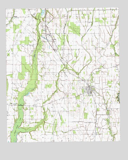
Gilbert, LA USGS Topographic Map
Click on map above to begin viewing in our Map Viewer.

This topographic map contains these locations and features:
Feature Name Type Latitude Longitude GNIS ID View Map
Ash SloughStreamN32.1154°W91.7137°541789View Map
Boggy BayouGutN32.1121°W91.6832°533290View Map
Boles ChapelChurchN32.0399°W91.7448°533307View Map
BrownellPopulated PlaceN32.1165°W91.7421°543031View Map
ChasePopulated PlaceN32.0971°W91.6990°543075View Map
Chase CemeteryCemeteryN32.1082°W91.7107°541676View Map
Chase ChurchChurchN32.0868°W91.6976°533885View Map
Chase ChurchChurchN32.0827°W91.6815°541677View Map
Chase Post OfficePost OfficeN32.0946°W91.6987°1630063View Map
GilbertPopulated PlaceN32.0493°W91.6582°543234View Map
Gilbert Junior High SchoolSchoolN32.0489°W91.6624°544091View Map
Holcombs Flying Service Incorporated Airport (historical)AirportN32.0682°W91.6262°1632716View Map
JiggerPopulated PlaceN32.0349°W91.7468°543343View Map
Jigger Apostolic ChurchChurchN32.0346°W91.7448°544582View Map
Jigger ChurchChurchN32.0252°W91.7496°541675View Map
Jigger Post OfficePost OfficeN32.0349°W91.7457°1630065View Map
Little Turkey CreekStreamN32.0093°W91.7398°536621View Map
Louisiana State University Research CenterLocaleN32.0999°W91.7015°556637View Map
Mount Olive ChurchChurchN32.0879°W91.6473°537362View Map
Oakley CemeteryCemeteryN32.0268°W91.6360°544096View Map
Oakley ChurchChurchN32.0274°W91.6368°537806View Map
Old Macedonia ChurchChurchN32.0702°W91.6282°537836View Map
Saint Mark ChurchChurchN32.0127°W91.6473°538964View Map
Stokes BayouGutN32.1171°W91.6973°539677View Map
Sweet Home ChurchChurchN32.1121°W91.6582°539756View Map
Turkey Creek Baptist ChurchChurchN32.0343°W91.7212°556281View Map
Union Grove ChurchChurchN32.0904°W91.7210°540105View Map
Village of GilbertCivilN32.0507°W91.6568°2407463View Map
Village of Gilbert Volunteer Fire DepartmentBuildingN32.0562°W91.6631°2673137View Map
Waller LandingPopulated PlaceN32.0415°W91.6271°543768View Map
Ward TwoCivilN32.0307°W91.6387°545027View Map
Wisner Junior High SchoolSchoolN32.0074°W91.6510°556463View Map
Wisner-Gilbert Airport (historical)AirportN32.0143°W91.6640°1633015View Map

Note: Coordinates in the location and feature list above are referenced to NAD83 datum.


Copyright (C) 2008-2025 Ryan Niemi / Sunset Dynamics ... All Rights Reserved