TopoQuest Logo
Do you find TopoQuest useful?
Help keep TopoQuest running and adding new maps/features by donating!
Bitcoin:  19c7KJd3qBynnjoSw5npx9KScwjBe4ifkT
Litecoin:  LXs6TkuXGGXo1vDsWCkWVdjQX94eUKd6ui
Home View Maps Find Maps Find Places Resources & Links


Beech Creek, Pennsylvania Topographic Map

USGS Map Title: Beech Creek, PA
USGS Map MRC: 41077A5
DRG (GeoTIFF) Download: o41077a5.tif


Neighboring USGS Topographic Map Quads:


  Howard NW, PA  
41077B6
 

  Farrandsville, PA  
41077B5
 

  Lock Haven, PA  
41077B4
 

  Howard, PA  
41077A6
 

  Beech Creek, PA  
41077A5
 

  Mill Hall, PA  
41077A4
 

  Mingoville, PA  
40077H6
 

  Madisonburg, PA  
40077H5
 

  Millheim, PA  
40077H4


Map MRC Location:

N42°
W78°
N42°
W77°
H8 H7 H6 H5 H4 H3 H2 H1
G8 G7 G6 G5 G4 G3 G2 G1
F8 F7 F6 F5 F4 F3 F2 F1
E8 E7 E6 E5 E4 E3 E2 E1
D8 D7 D6 D5 D4 D3 D2 D1
C8 C7 C6 C5 C4 C3 C2 C1
B8 B7 B6 B5 B4 B3 B2 B1
A8 A7 A6 A5 A4 A3 A2 A1
N41°
W78°
N41°
W77°

Beech Creek, PA USGS 1:24K Topographic Map Preview:
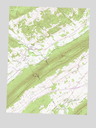
Beech Creek, PA USGS Topographic Map
Click on map above to begin viewing in our Map Viewer.

This topographic map contains these locations and features:
Feature Name Type Latitude Longitude GNIS ID View Map
AbderaPopulated PlaceN41.0306°W77.5608°1197104View Map
Bald Eagle State ParkParkN41.0417°W77.6030°1198248View Map
Beech CreekPopulated PlaceN41.0759°W77.5886°1169096View Map
Beech CreekStreamN41.0653°W77.5675°1169097View Map
Beech Creek Blanchard Fire Company Station 9BuildingN41.0760°W77.5873°2645598View Map
Beech Creek GapGapN41.0681°W77.5419°1169098View Map
Beech Creek Post OfficePost OfficeN41.0757°W77.5883°2773072View Map
Beech Creek StationLocaleN41.0648°W77.5661°1169100View Map
Beech Creek TowerTowerN41.0576°W77.5536°1212803View Map
Bitner RunStreamN41.0790°W77.5967°1169676View Map
Bitner SchoolSchoolN41.1159°W77.5914°1197106View Map
BlanchardPopulated PlaceN41.0642°W77.5978°1192165View Map
Blanchard Census Designated PlaceCensusN41.0663°W77.6079°2389214View Map
Blanchard Post OfficePost OfficeN41.0653°W77.5977°2772607View Map
Borough of Beech CreekCivilN41.0745°W77.5852°1215114View Map
Brown CemeteryCemeteryN41.1053°W77.5072°1170363View Map
Brown SchoolSchoolN41.1062°W77.5064°1197827View Map
Bunker HillSummitN41.1015°W77.5836°1170676View Map
Cedar SpringSpringN41.0492°W77.5247°1171402View Map
Cedar Spring School (historical)SchoolN41.0387°W77.5461°1197096View Map
Clark CemeteryCemeteryN41.0795°W77.5862°1171905View Map
ClintondalePopulated PlaceN41.0173°W77.5208°1203286View Map
Crystal SpringSpringN41.0548°W77.5158°1202285View Map
David Farm TrailTrailN41.1184°W77.6180°1172974View Map
EaglevillePopulated PlaceN41.0565°W77.5928°1173701View Map
Eagleville Census Designated PlaceCensusN41.0560°W77.5853°2584452View Map
Eagleville GapGapN41.0451°W77.5822°1173702View Map
East BeechPopulated PlaceN41.0770°W77.5500°1203469View Map
Foster Joseph Sayers DamDamN41.0483°W77.6088°1175041View Map
Frame SchoolSchoolN41.0184°W77.5855°1197105View Map
Haagen SchoolSchoolN41.0826°W77.5558°1197097View Map
Hays - Fearon CemeteryCemeteryN41.0698°W77.5703°1198864View Map
LamarPopulated PlaceN41.0162°W77.5311°1203975View Map
Lamar CampLocaleN41.0087°W77.5394°1178813View Map
Lamar Census Designated PlaceCensusN41.0095°W77.5306°2634235View Map
Lamar National Fish Hatchery and Northeast Fishery CenterParkN41.0028°W77.5332°1178815View Map
Lamar Post OfficePost OfficeN41.0137°W77.5335°2772778View Map
Lamar SpringSpringN41.0164°W77.5306°1202287View Map
Lamey SpringSpringN41.0534°W77.5172°1202284View Map
Laurel RunStreamN41.0934°W77.5144°1179017View Map
Liberty ChurchChurchN41.0615°W77.6003°1179259View Map
Liberty-Curtin SchoolSchoolN41.0681°W77.5980°1179270View Map
Little Fishing CreekStreamN41.0123°W77.5372°1179544View Map
Marsh CreekStreamN41.0587°W77.5961°1180446View Map
Masden RunStreamN41.0895°W77.5230°1180522View Map
Masden Run SchoolSchoolN41.1028°W77.5464°1197098View Map
McLane SpringSpringN41.0562°W77.5150°1202286View Map
Mount Bethel ChurchChurchN41.0390°W77.5136°1181644View Map
Nittany Valley Volunteer Fire Company Station 17BuildingN41.0157°W77.5317°2645588View Map
ParvinPopulated PlaceN41.0592°W77.5155°1183351View Map
Peters HollowValleyN41.0917°W77.5579°1183627View Map
Plunket RunStreamN41.1090°W77.5239°1184134View Map
Roaring RunStreamN41.0053°W77.5517°1185184View Map
Saint Pauls ChurchChurchN41.0428°W77.5086°1186625View Map
State Game Lands Number 255ParkN41.0667°W77.5414°1208341View Map
Steel SpringSpringN41.0006°W77.5339°1202282View Map
Sugar RunStreamN41.0778°W77.5947°1188966View Map
Sugar Run SchoolSchoolN41.0876°W77.5889°1197099View Map
Sunnyside CemeteryCemeteryN41.1210°W77.5077°1189078View Map
Township of PorterCivilN41.0289°W77.5156°1216269View Map
Washington Furnace SpringSpringN41.0037°W77.5333°1202283View Map
West BeechPopulated PlaceN41.0590°W77.5780°1204923View Map

Note: Coordinates in the location and feature list above are referenced to NAD83 datum.


Copyright (C) 2008-2024 Ryan Niemi / Sunset Dynamics ... All Rights Reserved