TopoQuest Logo
Do you find TopoQuest useful?
Help keep TopoQuest running and adding new maps/features by donating!
Bitcoin:  19c7KJd3qBynnjoSw5npx9KScwjBe4ifkT
Litecoin:  LXs6TkuXGGXo1vDsWCkWVdjQX94eUKd6ui
Home View Maps Find Maps Find Places Resources & Links


Mill Hall, Pennsylvania Topographic Map

USGS Map Title: Mill Hall, PA
USGS Map MRC: 41077A4
DRG (GeoTIFF) Download: o41077a4.tif


Neighboring USGS Topographic Map Quads:


  Farrandsville, PA  
41077B5
 

  Lock Haven, PA  
41077B4
 

  Jersey Shore, PA  
41077B3
 

  Beech Creek, PA  
41077A5
 

  Mill Hall, PA  
41077A4
 

  Loganton, PA  
41077A3
 

  Madisonburg, PA  
40077H5
 

  Millheim, PA  
40077H4
 

  Woodward, PA  
40077H3


Map MRC Location:

N42°
W78°
N42°
W77°
H8 H7 H6 H5 H4 H3 H2 H1
G8 G7 G6 G5 G4 G3 G2 G1
F8 F7 F6 F5 F4 F3 F2 F1
E8 E7 E6 E5 E4 E3 E2 E1
D8 D7 D6 D5 D4 D3 D2 D1
C8 C7 C6 C5 C4 C3 C2 C1
B8 B7 B6 B5 B4 B3 B2 B1
A8 A7 A6 A5 A4 A3 A2 A1
N41°
W78°
N41°
W77°

Mill Hall, PA USGS 1:24K Topographic Map Preview:
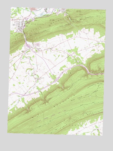
Mill Hall, PA USGS Topographic Map
Click on map above to begin viewing in our Map Viewer.

This topographic map contains these locations and features:
Feature Name Type Latitude Longitude GNIS ID View Map
Axe Factory HollowValleyN41.0951°W77.4782°1168534View Map
Axe Factory RunStreamN41.0934°W77.4797°1202645View Map
Big MountainSummitN41.0234°W77.4469°1169540View Map
Big SpringSpringN41.0840°W77.4578°1201333View Map
Borough of Mill HallCivilN41.1045°W77.4888°1215118View Map
Brick SchoolSchoolN41.0959°W77.3991°1196765View Map
Buzzards FieldAirportN41.0938°W77.4144°2443047View Map
CastaneaPopulated PlaceN41.1248°W77.4297°1171315View Map
Castanea Census Designated PlaceCensusN41.1200°W77.4287°2389285View Map
Castanea Post OfficePost OfficeN41.1246°W77.4317°2773094View Map
Cedar Hill CemeteryCemeteryN41.0780°W77.4781°1171381View Map
Cedar RunStreamN41.0820°W77.4783°1171397View Map
Cedar SpringsPopulated PlaceN41.0815°W77.4797°1171404View Map
Chub RunStreamN41.0842°W77.4347°1171835View Map
Clinton SchoolSchoolN41.0312°W77.4919°1196767View Map
Disciples CemeteryCemeteryN41.0811°W77.4646°1173294View Map
DraketownPopulated PlaceN41.1131°W77.4692°1173456View Map
Fishing CreekStreamN41.1223°W77.4828°1174841View Map
Goodwill Hose Fire Company Station 7BuildingN41.1231°W77.4717°2645597View Map
Lamar SchoolSchoolN41.0853°W77.4455°1178816View Map
Lamar Township Volunteer Fire Department Station 11BuildingN41.0843°W77.4618°2645600View Map
Logan MillsPopulated PlaceN41.0067°W77.3828°1179813View Map
Long RunStreamN41.0870°W77.4692°1179894View Map
MackeyvillePopulated PlaceN41.0545°W77.4614°1180163View Map
Mackeyville Post OfficePost OfficeN41.0542°W77.4655°2772814View Map
Mill HallPopulated PlaceN41.1073°W77.4844°1181167View Map
Mill Hall Fire Company Station 4BuildingN41.1097°W77.4873°2645582View Map
Mill Hall Police DepartmentBuildingN41.1118°W77.4925°2776960View Map
Mill Hall Post OfficePost OfficeN41.1061°W77.4853°2772838View Map
Pennsylvania State Police Troop F Lamar StationBuildingN41.0651°W77.4913°2777340View Map
Poverty AirportAirportN41.0623°W77.4322°2443025View Map
Riansares MountainSummitN41.0520°W77.3797°1184986View Map
Ridge SchoolSchoolN41.0640°W77.4439°1196766View Map
RotePopulated PlaceN41.0790°W77.4203°1185507View Map
Rote Census Designated PlaceCensusN41.0781°W77.4114°2630037View Map
SalonaPopulated PlaceN41.0842°W77.4630°1214008View Map
Salona QuarryMineN41.0889°W77.4644°2703883View Map
Stamm TrailTrailN41.0381°W77.3983°1188389View Map
Sugar Valley MountainSummitN41.0070°W77.4253°1188981View Map
The TalladegaRidgeN41.1103°W77.3803°2414576View Map
Township of CastaneaCivilN41.1219°W77.4167°1216255View Map
Township of LamarCivilN41.0695°W77.4153°1216264View Map
Upper Castanea ReservoirReservoirN41.1148°W77.4217°1190227View Map
Upper Castanea Reservoir DamDamN41.1167°W77.4197°1195278View Map
Valley Dairy SpringSpringN41.0595°W77.4747°1202171View Map
West Kammerdiner RunStreamN41.1134°W77.4200°1191049View Map
Winter TrailTrailN41.0459°W77.4000°1191611View Map

Note: Coordinates in the location and feature list above are referenced to NAD83 datum.


Copyright (C) 2008-2024 Ryan Niemi / Sunset Dynamics ... All Rights Reserved