TopoQuest Logo
Do you find TopoQuest useful?
Help keep TopoQuest running and adding new maps/features by donating!
Bitcoin:  19c7KJd3qBynnjoSw5npx9KScwjBe4ifkT
Litecoin:  LXs6TkuXGGXo1vDsWCkWVdjQX94eUKd6ui
Home View Maps Find Maps Find Places Resources & Links


Howard, Pennsylvania Topographic Map

USGS Map Title: Howard, PA
USGS Map MRC: 41077A6
DRG (GeoTIFF) Download: o41077a6.tif


Neighboring USGS Topographic Map Quads:


  Snow Shoe NE, PA  
41077B7
 

  Howard NW, PA  
41077B6
 

  Farrandsville, PA  
41077B5
 

  Snow Shoe SE, PA  
41077A7
 

  Howard, PA  
41077A6
 

  Beech Creek, PA  
41077A5
 

  Bellefonte, PA  
40077H7
 

  Mingoville, PA  
40077H6
 

  Madisonburg, PA  
40077H5


Map MRC Location:

N42°
W78°
N42°
W77°
H8 H7 H6 H5 H4 H3 H2 H1
G8 G7 G6 G5 G4 G3 G2 G1
F8 F7 F6 F5 F4 F3 F2 F1
E8 E7 E6 E5 E4 E3 E2 E1
D8 D7 D6 D5 D4 D3 D2 D1
C8 C7 C6 C5 C4 C3 C2 C1
B8 B7 B6 B5 B4 B3 B2 B1
A8 A7 A6 A5 A4 A3 A2 A1
N41°
W78°
N41°
W77°

Howard, PA USGS 1:24K Topographic Map Preview:
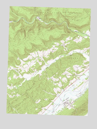
Howard, PA USGS Topographic Map
Click on map above to begin viewing in our Map Viewer.

This topographic map contains these locations and features:
Feature Name Type Latitude Longitude GNIS ID View Map
Bartley RunStreamN41.0670°W77.7022°1168780View Map
Bartley TrailTrailN41.0801°W77.7100°1192097View Map
Beatty HollowValleyN41.0031°W77.7338°1168983View Map
Betz HollowValleyN41.0185°W77.7107°1169443View Map
Big RunPopulated PlaceN41.0815°W77.6678°1169561View Map
Big RunStreamN41.0709°W77.6536°1169566View Map
Big RunStreamN41.1112°W77.7336°1169581View Map
Big Run SchoolSchoolN41.0812°W77.6683°1197107View Map
Borough of HowardCivilN41.0128°W77.6575°1215056View Map
Canoe HollowValleyN41.0202°W77.7148°1171172View Map
Foster Joseph Sayers LakeReservoirN41.0235°W77.6498°1192482View Map
Green HollowValleyN41.1060°W77.7132°1176078View Map
Green Hollow TrailTrailN41.0878°W77.7281°1192546View Map
Greens RunStreamN41.0067°W77.6900°1198838View Map
Highland ChurchChurchN41.0370°W77.6769°1177032View Map
HowardPopulated PlaceN41.0142°W77.6581°1177517View Map
Howard Fire Company 14BuildingN41.0149°W77.6578°2644960View Map
Howard Post OfficePost OfficeN41.0142°W77.6589°2772750View Map
Hunters RunStreamN41.0473°W77.6408°1177618View Map
Lick RunStreamN41.0159°W77.6525°1179308View Map
Little Marsh CreekStreamN41.0395°W77.7208°1179593View Map
Mann SchoolSchoolN41.0490°W77.7331°1209044View Map
Mapes (historical)LocaleN41.1017°W77.6555°1197112View Map
Marsh Creek ChurchChurchN41.0490°W77.7331°1200098View Map
MonumentPopulated PlaceN41.1112°W77.7044°1181487View Map
Monument Census Designated PlaceCensusN41.1112°W77.7042°2389502View Map
Monument RunStreamN41.1137°W77.7042°1181490View Map
Null SchoolSchoolN41.0309°W77.7406°1197109View Map
Pleasant View School (historical)SchoolN41.0290°W77.6556°1197110View Map
Pole Bridge HollowValleyN41.0233°W77.7195°1184186View Map
Quay SchoolSchoolN41.0628°W77.6953°1197108View Map
RomolaPopulated PlaceN41.0570°W77.6892°1185417View Map
Romola BranchStreamN41.0570°W77.6850°1185418View Map
Salt Lick RunStreamN41.1067°W77.7217°1186877View Map
Salt Lick TrailTrailN41.0970°W77.7308°1193275View Map
Schencks CemeteryCemeteryN41.0109°W77.6772°1187076View Map
Slide HollowValleyN41.1072°W77.6978°1187807View Map
Slide Hollow TrailTrailN41.0956°W77.7028°1193374View Map
Smith HollowValleyN41.0059°W77.7379°1187876View Map
Stone RunStreamN41.0095°W77.7431°1188736View Map
Sugar Camp RunStreamN41.1084°W77.6789°1188925View Map
Swamp TrailTrailN41.1173°W77.6439°1193506View Map
Sylvan Hills CampLocaleN41.0331°W77.7428°1189218View Map
Tar Kill HollowValleyN41.0410°W77.7111°1189270View Map
Tempsmith TrailTrailN41.1156°W77.6464°1193521View Map
The CoveBayN41.1090°W77.6664°1189397View Map
Township of HowardCivilN41.0103°W77.6881°1216128View Map
Township of LibertyCivilN41.0685°W77.6413°1216130View Map
Trapping HollowValleyN41.0985°W77.7282°1193546View Map
Trapping Hollow TrailTrailN41.0901°W77.7244°1193547View Map
Turkey TrailTrailN41.0820°W77.7028°1193562View Map
Twin RunStreamN41.1076°W77.6939°1190014View Map
Wagner School (historical)SchoolN41.0559°W77.6431°1197111View Map
WoodLocaleN41.0212°W77.6381°1190965View Map

Note: Coordinates in the location and feature list above are referenced to NAD83 datum.


Copyright (C) 2008-2025 Ryan Niemi / Sunset Dynamics ... All Rights Reserved