TopoQuest Logo
Do you find TopoQuest useful?
Help keep TopoQuest running and adding new maps/features by donating!
Bitcoin:  19c7KJd3qBynnjoSw5npx9KScwjBe4ifkT
Litecoin:  LXs6TkuXGGXo1vDsWCkWVdjQX94eUKd6ui
Home View Maps Find Maps Find Places Resources & Links


Marble, Arkansas Topographic Map

USGS Map Title: Marble, AR
USGS Map MRC: 36093B5
DRG (GeoTIFF) Download: o36093b5.tif


Neighboring USGS Topographic Map Quads:


  Rockhouse, AR  
36093C6
 

  Berryville, AR  
36093C5
 

  Green Forest, AR  
36093C4
 

  Forum, AR  
36093B6
 

  Marble, AR  
36093B5
 

  Osage, AR  
36093B4
 

  Huntsville, AR  
36093A6
 

  Kingston, AR  
36093A5
 

  Osage SW, AR  
36093A4


Map MRC Location:

N37°
W94°
N37°
W93°
H8 H7 H6 H5 H4 H3 H2 H1
G8 G7 G6 G5 G4 G3 G2 G1
F8 F7 F6 F5 F4 F3 F2 F1
E8 E7 E6 E5 E4 E3 E2 E1
D8 D7 D6 D5 D4 D3 D2 D1
C8 C7 C6 C5 C4 C3 C2 C1
B8 B7 B6 B5 B4 B3 B2 B1
A8 A7 A6 A5 A4 A3 A2 A1
N36°
W94°
N36°
W93°

Marble, AR USGS 1:24K Topographic Map Preview:
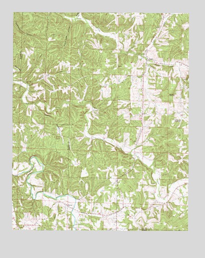
Marble, AR USGS Topographic Map
Click on map above to begin viewing in our Map Viewer.

This topographic map contains these locations and features:
Feature Name Type Latitude Longitude GNIS ID View Map
Big Onion CreekStreamN36.1431°W93.5949°46586View Map
Brushy HollowValleyN36.2476°W93.5805°47082View Map
Cave SpringSpringN36.1948°W93.5674°69199View Map
Cave Spring (historical)Populated PlaceN36.2048°W93.5730°69200View Map
Cedar CreekStreamN36.2259°W93.5352°47597View Map
Chinkapin MountainSummitN36.1879°W93.5110°57547View Map
DeanPopulated PlaceN36.1920°W93.5338°76765View Map
Dean CemeteryCemeteryN36.1923°W93.5338°1959668View Map
Dean School (historical)SchoolN36.1915°W93.5332°69204View Map
Lower Campground ChurchChurchN36.1254°W93.5535°51497View Map
MarblePopulated PlaceN36.1398°W93.5874°58121View Map
Marble Fire DepartmentBuildingN36.1384°W93.5865°2116761View Map
Merl CemeteryCemeteryN36.1778°W93.5952°51917View Map
MetaltonPopulated PlaceN36.2231°W93.5299°57114View Map
Rays CoveValleyN36.1270°W93.6224°66410View Map
Sites BranchStreamN36.1554°W93.5010°54879View Map
Smith HeliportAirportN36.2240°W93.5782°83643View Map
Tarkiln HollowValleyN36.1967°W93.6085°55434View Map
Township of OmegaCivilN36.2134°W93.5642°66904View Map
Wagon Shed HollowValleyN36.2445°W93.5838°78667View Map
Walker MountainSummitN36.2034°W93.5152°58817View Map
White Oak CemeteryCemeteryN36.2101°W93.6157°56262View Map
White Oak ChurchChurchN36.2081°W93.6141°56270View Map
White Oak HollowValleyN36.2090°W93.6132°78759View Map
Wolf Pen (historical)Populated PlaceN36.1781°W93.5688°69249View Map

Note: Coordinates in the location and feature list above are referenced to NAD83 datum.


Copyright (C) 2008-2024 Ryan Niemi / Sunset Dynamics ... All Rights Reserved